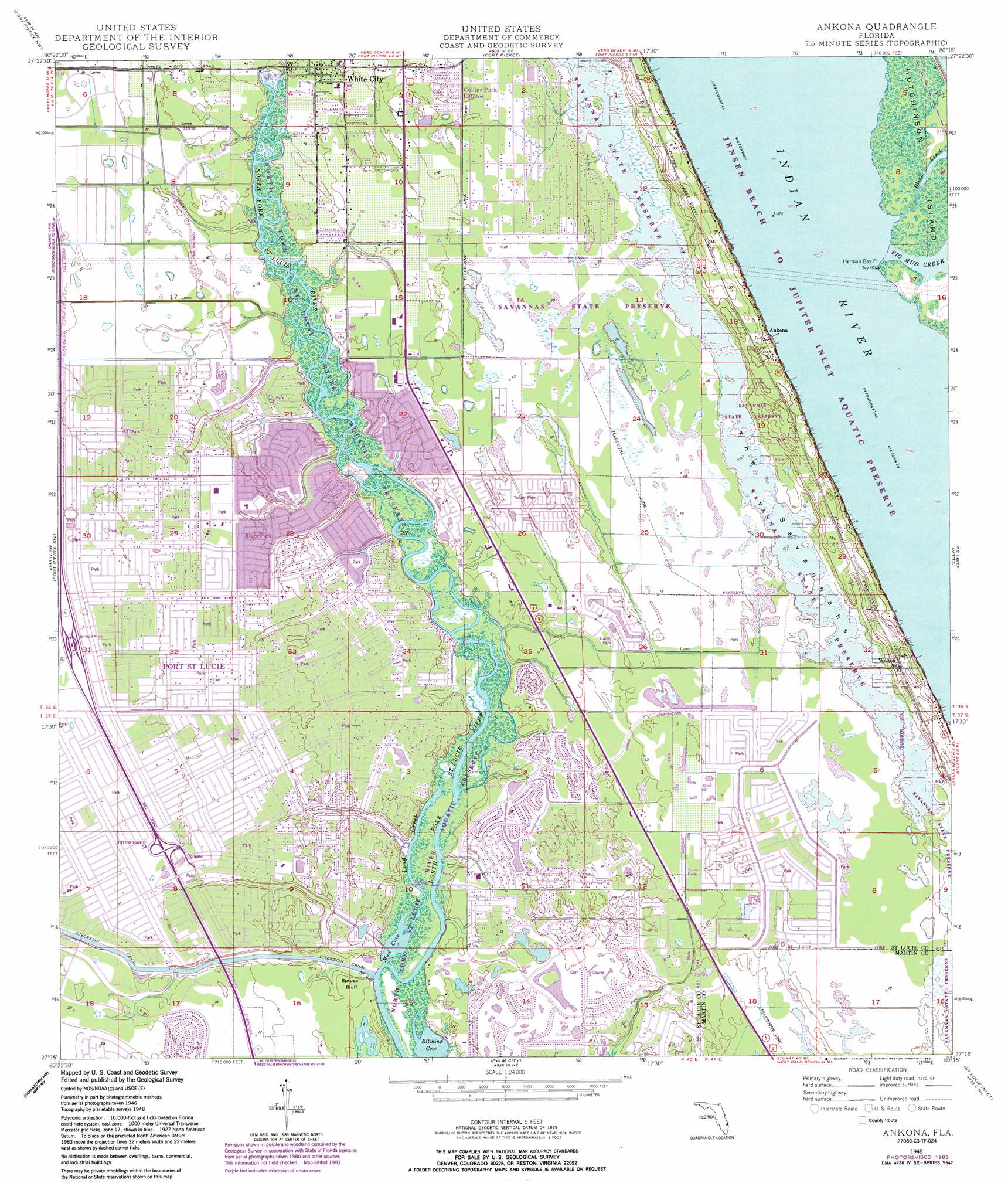
Ankona Topo Map Florida
To zoom in, hover over the map of Ankona
USGS Topo Quad 27080c3 - 1:24,000 scale
| Topo Map Name: | Ankona |
| USGS Topo Quad ID: | 27080c3 |
| Print Size: | ca. 21 1/4" wide x 27" high |
| Southeast Coordinates: | 27.25° N latitude / 80.25° W longitude |
| Map Center Coordinates: | 27.3125° N latitude / 80.3125° W longitude |
| U.S. State: | FL |
| Filename: | O27080C3.jpg |
| Download Map JPG Image: | Ankona topo map 1:24,000 scale |
| Map Type: | Topographic |
| Topo Series: | 7.5´ |
| Map Scale: | 1:24,000 |
| Source of Map Images: | United States Geological Survey (USGS) |
| Alternate Map Versions: |
Ankona FL 1948, updated 1956 Download PDF Buy paper map Ankona FL 1948, updated 1971 Download PDF Buy paper map Ankona FL 1948, updated 1972 Download PDF Buy paper map Ankona FL 1948, updated 1983 Download PDF Buy paper map Ankona FL 1950 Download PDF Buy paper map Ankona FL 2012 Download PDF Buy paper map Ankona FL 2015 Download PDF Buy paper map |
1:24,000 Topo Quads surrounding Ankona
Fellsmere 4 Se |
Oslo |
Indrio |
||
Okeechobee 1 Ne |
Fort Pierce Nw |
Fort Pierce |
||
Okeechobee 1 Se |
Fort Pierce Sw |
Ankona |
Eden |
|
Okeechobee 4 Ne |
Indian Town Nw |
Palm City |
Saint Lucie Inlet |
|
Okeechobee 4 Se |
Indian Town |
Indiantown Se |
Gomez |
Hobe Sound |
> Back to 27080a1 at 1:100,000 scale
> Back to 27080a1 at 1:250,000 scale
> Back to U.S. Topo Maps home
Ankona topo map: Gazetteer
Ankona: Airports
Kitching Cove Seaplane Base elevation 2m 6′Saint Lucie Medical Center Heliport elevation 4m 13′
Ankona: Bays
Mud Cove elevation 1m 3′Ankona: Capes
Herman Bay Point elevation 0m 0′Ankona: Cliffs
Spruce Bluff elevation 3m 9′Ankona: Parks
North Fork Saint Lucie River Aquatic Preserve elevation 1m 3′Ankona: Populated Places
Ankona elevation 4m 13′Collins Park Estates elevation 4m 13′
Eldred elevation 6m 19′
H and H Mobile Home Park elevation 3m 9′
Indian River Estates elevation 4m 13′
La Buona Vita Mobile Home Park elevation 2m 6′
Port Saint Lucie elevation 5m 16′
River Park elevation 4m 13′
Spanish Lakes Golf Village Mobile Home Park elevation 4m 13′
Spanish Lakes Riverfront Mobile Home Park elevation 4m 13′
Tropical Isles Mobile Home Park elevation 4m 13′
Walton elevation 11m 36′
White City elevation 4m 13′
Ankona: Streams
Big Mud Creek elevation 0m 0′Blind Creek elevation 0m 0′
Long Creek elevation 2m 6′
Ankona: Swamps
The Savannahs elevation 4m 13′Ankona digital topo map on disk
Buy this Ankona topo map showing relief, roads, GPS coordinates and other geographical features, as a high-resolution digital map file on DVD: