Taylor Creek Se Topo Map Florida
To zoom in, hover over the map of Taylor Creek Se
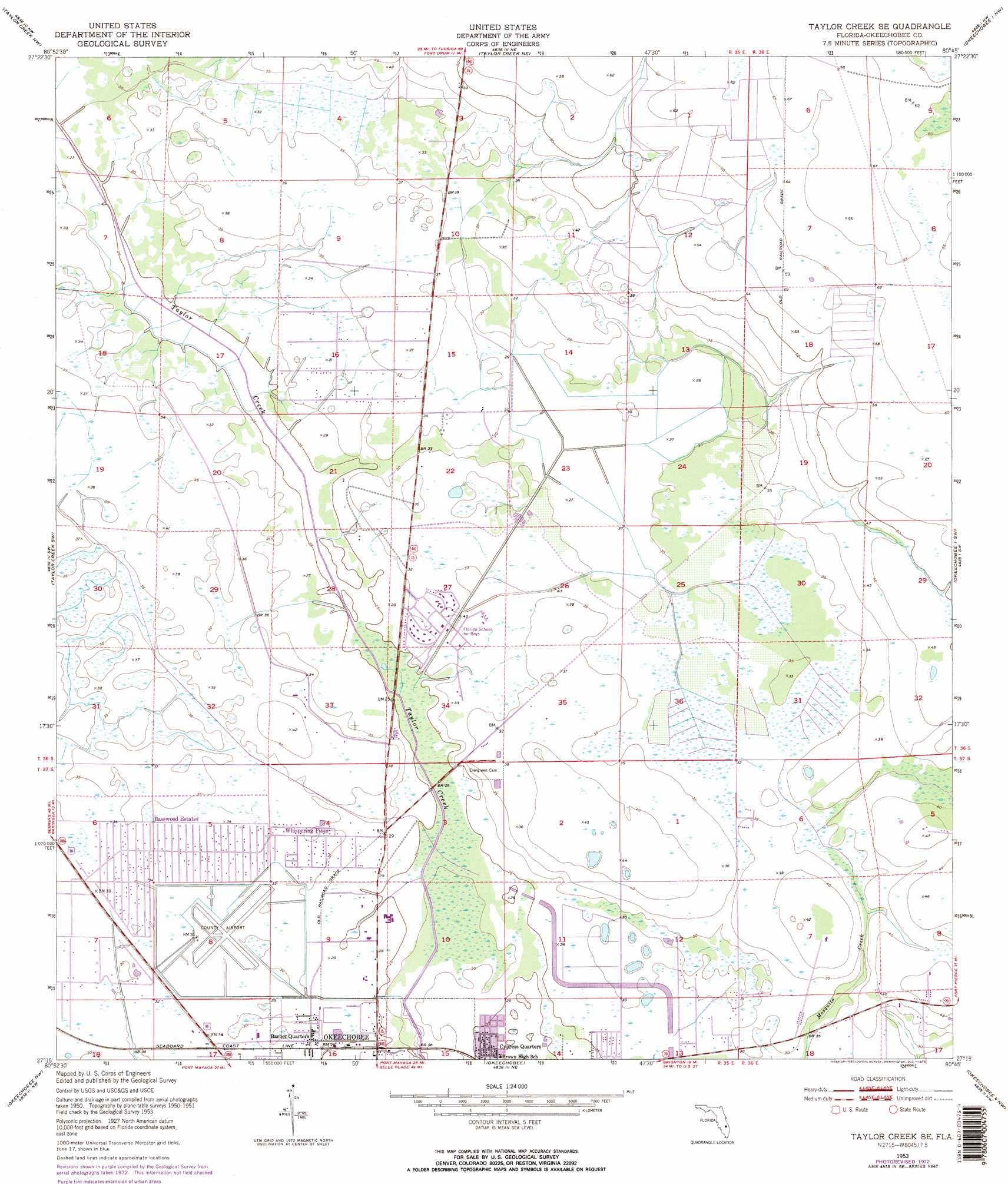
USGS Topo Quad 27080c7 - 1:24,000 scale
| Topo Map Name: | Taylor Creek Se |
| USGS Topo Quad ID: | 27080c7 |
| Print Size: | ca. 21 1/4" wide x 27" high |
| Southeast Coordinates: | 27.25° N latitude / 80.75° W longitude |
| Map Center Coordinates: | 27.3125° N latitude / 80.8125° W longitude |
| U.S. State: | FL |
| Filename: | O27080C7.jpg |
| Download Map JPG Image: | Taylor Creek Se topo map 1:24,000 scale |
| Map Type: | Topographic |
| Topo Series: | 7.5´ |
| Map Scale: | 1:24,000 |
| Source of Map Images: | United States Geological Survey (USGS) |
| Alternate Map Versions: |
Taylor Creek SE FL 1953, updated 1954 Download PDF Buy paper map Taylor Creek SE FL 1953, updated 1973 Download PDF Buy paper map Taylor Creek SE FL 1953, updated 1973 Download PDF Buy paper map Taylor Creek SE FL 2012 Download PDF Buy paper map Taylor Creek SE FL 2015 Download PDF Buy paper map |
1:24,000 Topo Quads surrounding Taylor Creek Se
Fort Kissimmee Se |
Fort Drum Sw |
Fort Drum |
Fellsmere 4 Sw |
Fellsmere 4 Se |
Basinger |
Taylor Creek Nw |
Taylor Creek Ne |
Okeechobee 1 Nw |
Okeechobee 1 Ne |
Fort Basinger |
Taylor Creek Sw |
Taylor Creek Se |
Okeechobee 1 Sw |
Okeechobee 1 Se |
Brighton |
Okeechobee Nw |
Okeechobee |
Okeechobee 4 Nw |
Okeechobee 4 Ne |
Brighton Se |
Okeechobee Sw |
Okeechobee Se |
Okeechobee 4 Sw |
Okeechobee 4 Se |
> Back to 27080a1 at 1:100,000 scale
> Back to 27080a1 at 1:250,000 scale
> Back to U.S. Topo Maps home
Taylor Creek Se topo map: Gazetteer
Taylor Creek Se: Airports
HCA-Raulerson Hospital Heliport elevation 8m 26′Okeechobee County Airport elevation 9m 29′
Paxton Airport elevation 20m 65′
Sunniland Ranch Airport elevation 19m 62′
Taylor Creek Se: Islands
Eagle Island elevation 10m 32′Taylor Creek Se: Populated Places
Azteca Mobile Home Park elevation 9m 29′Barber Quarters elevation 9m 29′
Basswood Estates elevation 10m 32′
Cypress Quarters elevation 8m 26′
Eighth Street Mobile Home Park elevation 9m 29′
Enchanted Forest Mobile Home Park elevation 7m 22′
Palm Village Mobile Home Park elevation 8m 26′
Pine Ridge Park Mobile Home Park elevation 7m 22′
Villa Margaret Trailer Park elevation 8m 26′
Whispering Pines elevation 9m 29′
Taylor Creek Se digital topo map on disk
Buy this Taylor Creek Se topo map showing relief, roads, GPS coordinates and other geographical features, as a high-resolution digital map file on DVD: