Indrio Topo Map Florida
To zoom in, hover over the map of Indrio
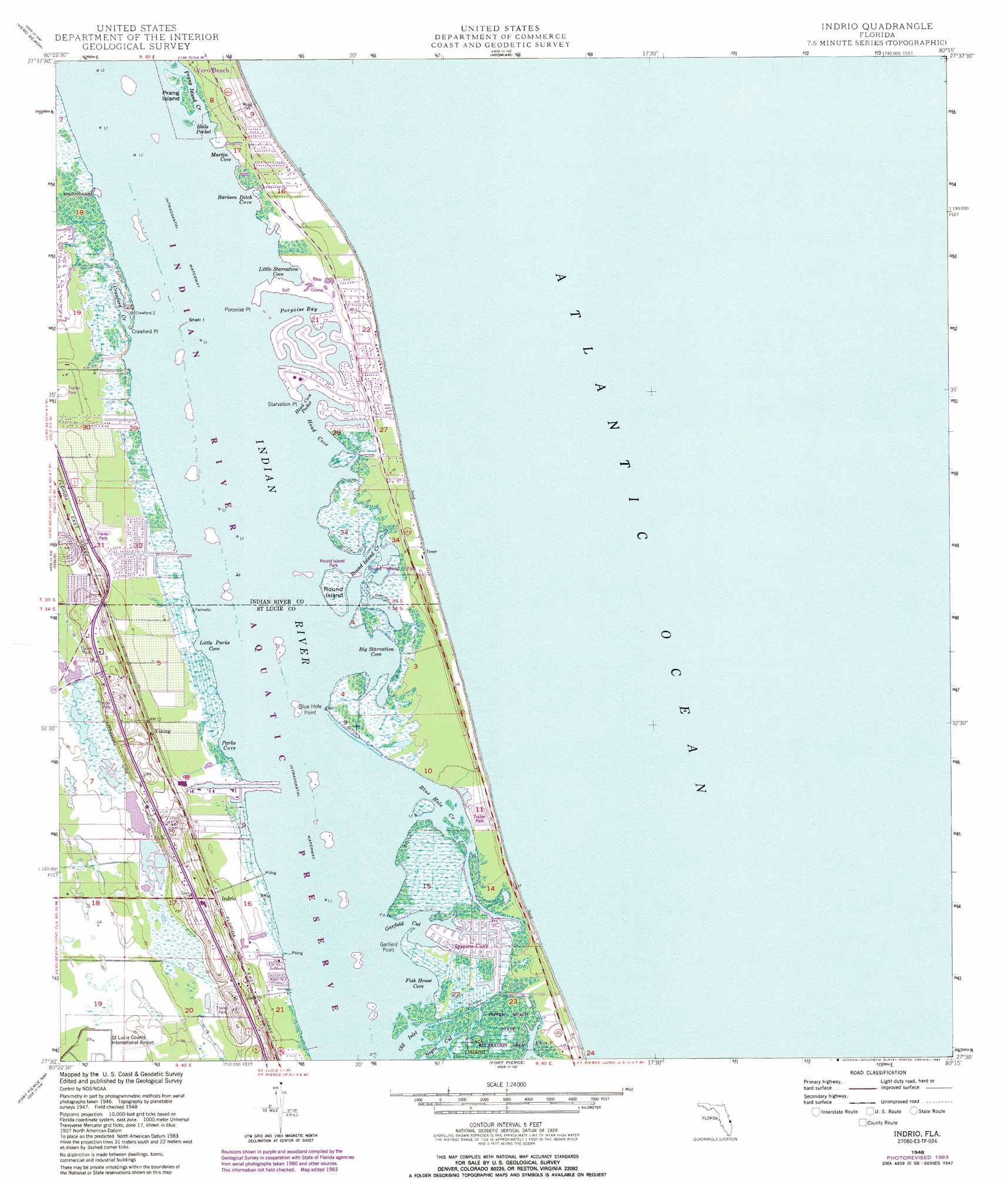
USGS Topo Quad 27080e3 - 1:24,000 scale
| Topo Map Name: | Indrio |
| USGS Topo Quad ID: | 27080e3 |
| Print Size: | ca. 21 1/4" wide x 27" high |
| Southeast Coordinates: | 27.5° N latitude / 80.25° W longitude |
| Map Center Coordinates: | 27.5625° N latitude / 80.3125° W longitude |
| U.S. State: | FL |
| Filename: | O27080E3.jpg |
| Download Map JPG Image: | Indrio topo map 1:24,000 scale |
| Map Type: | Topographic |
| Topo Series: | 7.5´ |
| Map Scale: | 1:24,000 |
| Source of Map Images: | United States Geological Survey (USGS) |
| Alternate Map Versions: |
Indrio FL 1948, updated 1968 Download PDF Buy paper map Indrio FL 1948, updated 1970 Download PDF Buy paper map Indrio FL 1948, updated 1984 Download PDF Buy paper map Indrio FL 1948, updated 1984 Download PDF Buy paper map Indrio FL 1950 Download PDF Buy paper map Indrio FL 2012 Download PDF Buy paper map Indrio FL 2015 Download PDF Buy paper map |
1:24,000 Topo Quads surrounding Indrio
Fellsmere |
Sebastian |
|||
Fellsmere 4 Ne |
Vero Beach |
Riomar |
||
Fellsmere 4 Se |
Oslo |
Indrio |
||
Okeechobee 1 Ne |
Fort Pierce Nw |
Fort Pierce |
||
Okeechobee 1 Se |
Fort Pierce Sw |
Ankona |
Eden |
> Back to 27080e1 at 1:100,000 scale
> Back to 27080a1 at 1:250,000 scale
> Back to U.S. Topo Maps home
Indrio topo map: Gazetteer
Indrio: Bays
Barkers Ditch Cove elevation 0m 0′Big Starvation Cove elevation 0m 0′
Fish House Cove elevation 0m 0′
Head Cove elevation 0m 0′
Head Cove Pocket elevation 0m 0′
Hells Pocket elevation 0m 0′
Little Parks Cove elevation 0m 0′
Little Starvation Cove elevation 0m 0′
Martin Cove elevation 0m 0′
Old Inlet elevation 0m 0′
Parks Cove elevation 0m 0′
Porpoise Bay elevation 0m 0′
Indrio: Capes
Blue Hole Point elevation 0m 0′Crawford Point elevation 0m 0′
Garfield Point elevation 0m 0′
Porpoise Point elevation 0m 0′
Starvation Point elevation 0m 0′
Indrio: Guts
Blue Hole Creek elevation 0m 0′Crawford Creek elevation 0m 0′
Garfield Cut elevation 0m 0′
Negro Cut elevation 0m 0′
Prang Island Creek elevation 0m 0′
Round Island elevation 0m 0′
Indrio: Islands
North Hutchinson Island elevation 1m 3′Prang Island elevation 0m 0′
Round Island elevation 0m 0′
Shell Island elevation 0m 0′
Indrio: Parks
Avalon State Park elevation 4m 13′Pepper Beach State Recreation Area elevation 0m 0′
Round Island Park elevation 1m 3′
Indrio: Populated Places
Country Cove Mobile Home Community elevation 10m 32′Cypress Bay Mobile Home Park elevation 5m 16′
Indrio elevation 4m 13′
Midway Estates Mobile Home Park elevation 1m 3′
Queens Cove elevation 0m 0′
South Beach elevation 0m 0′
Torpey Oaks Mobile Home Park elevation 8m 26′
Viking elevation 4m 13′
Indrio digital topo map on disk
Buy this Indrio topo map showing relief, roads, GPS coordinates and other geographical features, as a high-resolution digital map file on DVD: