Oslo Topo Map Florida
To zoom in, hover over the map of Oslo
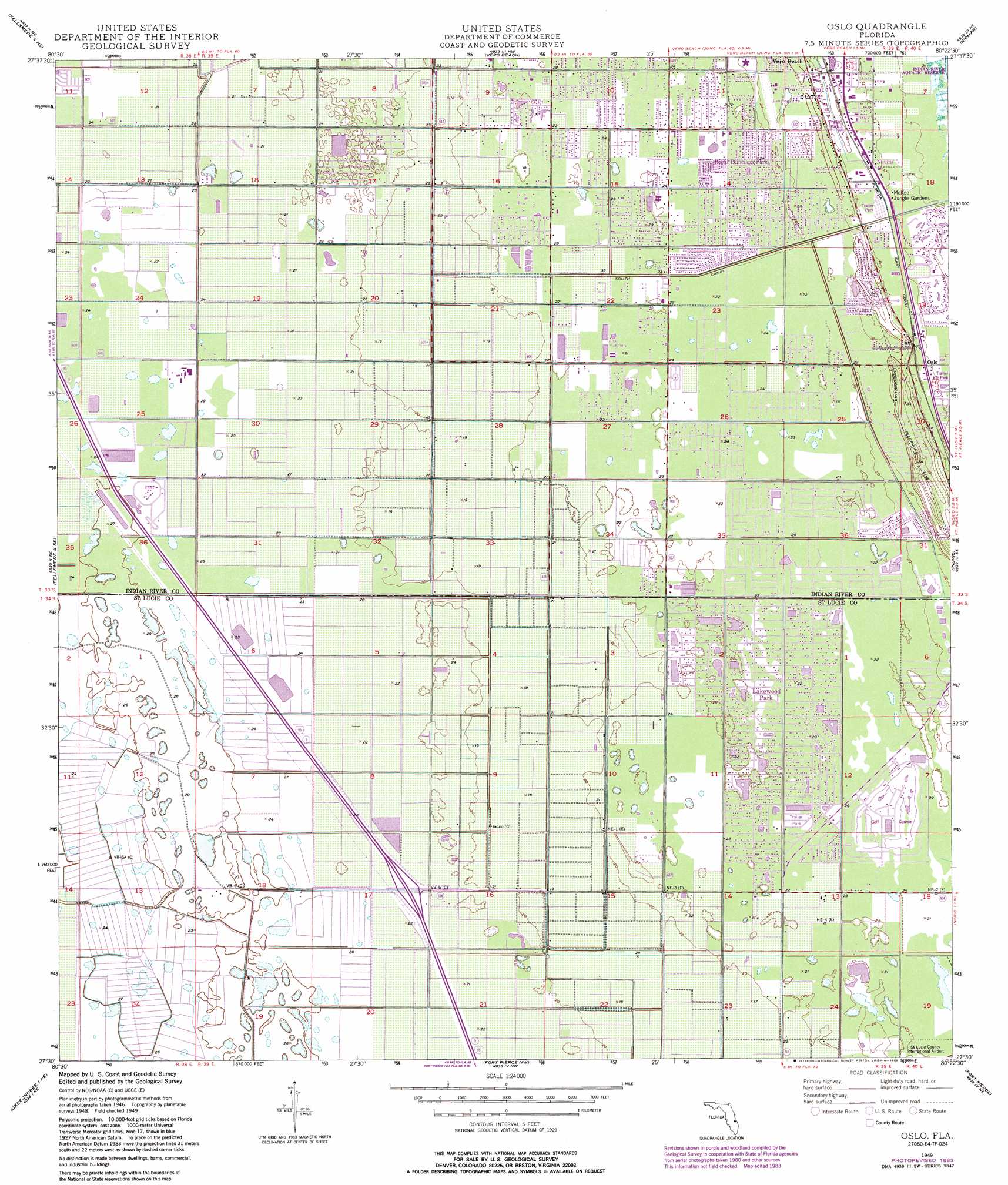
USGS Topo Quad 27080e4 - 1:24,000 scale
| Topo Map Name: | Oslo |
| USGS Topo Quad ID: | 27080e4 |
| Print Size: | ca. 21 1/4" wide x 27" high |
| Southeast Coordinates: | 27.5° N latitude / 80.375° W longitude |
| Map Center Coordinates: | 27.5625° N latitude / 80.4375° W longitude |
| U.S. State: | FL |
| Filename: | O27080E4.jpg |
| Download Map JPG Image: | Oslo topo map 1:24,000 scale |
| Map Type: | Topographic |
| Topo Series: | 7.5´ |
| Map Scale: | 1:24,000 |
| Source of Map Images: | United States Geological Survey (USGS) |
| Alternate Map Versions: |
Oslo FL 1949, updated 1964 Download PDF Buy paper map Oslo FL 1949, updated 1972 Download PDF Buy paper map Oslo FL 1950 Download PDF Buy paper map Oslo FL 2012 Download PDF Buy paper map Oslo FL 2015 Download PDF Buy paper map |
1:24,000 Topo Quads surrounding Oslo
Fellsmere Sw |
Fellsmere |
Sebastian |
||
Fellsmere 4 Nw |
Fellsmere 4 Ne |
Vero Beach |
Riomar |
|
Fellsmere 4 Sw |
Fellsmere 4 Se |
Oslo |
Indrio |
|
Okeechobee 1 Nw |
Okeechobee 1 Ne |
Fort Pierce Nw |
Fort Pierce |
|
Okeechobee 1 Sw |
Okeechobee 1 Se |
Fort Pierce Sw |
Ankona |
Eden |
> Back to 27080e1 at 1:100,000 scale
> Back to 27080a1 at 1:250,000 scale
> Back to U.S. Topo Maps home
Oslo topo map: Gazetteer
Oslo: Airports
Falcon Ridge Airpark elevation 7m 22′Fly in Ranches Airport elevation 7m 22′
Triple M Airport elevation 6m 19′
Oslo: Populated Places
Coachland Court Mobile Home Park elevation 6m 19′Florida Ridge elevation 6m 19′
Heritage Plantation Mobile Home Park elevation 6m 19′
Holiday Village Mobile Home Park elevation 6m 19′
Lakewood Park elevation 6m 19′
Maggie Runyon Trailer Park elevation 4m 13′
Nevins elevation 3m 9′
Oslo elevation 4m 13′
Poinciana Park elevation 6m 19′
Royal Poinciana Park elevation 6m 19′
Southgate Village Mobile Home Park elevation 3m 9′
Spanish Lakes Country Club Village Mobile Home Park elevation 6m 19′
Squire Village Mobile Home Park elevation 6m 19′
Su - Rene Mobile Park elevation 4m 13′
Tanglewood Village Mobile Home Park elevation 2m 6′
Woodlawn Manor Mobile Home Park elevation 3m 9′
Oslo: Post Offices
Tropic Post Office elevation 3m 9′Oslo digital topo map on disk
Buy this Oslo topo map showing relief, roads, GPS coordinates and other geographical features, as a high-resolution digital map file on DVD: