Fort Drum Topo Map Florida
To zoom in, hover over the map of Fort Drum
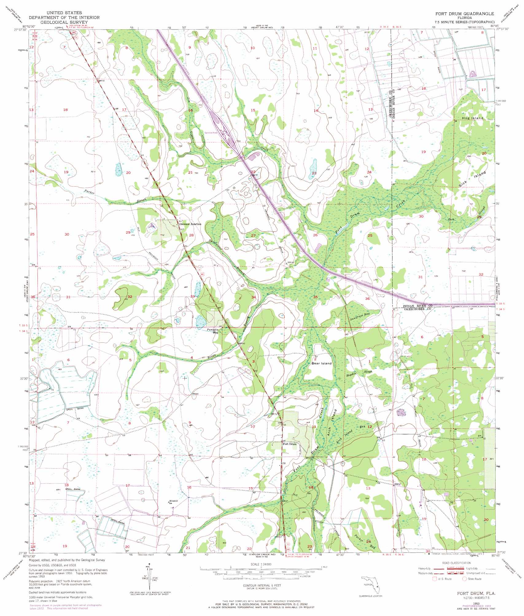
USGS Topo Quad 27080e7 - 1:24,000 scale
| Topo Map Name: | Fort Drum |
| USGS Topo Quad ID: | 27080e7 |
| Print Size: | ca. 21 1/4" wide x 27" high |
| Southeast Coordinates: | 27.5° N latitude / 80.75° W longitude |
| Map Center Coordinates: | 27.5625° N latitude / 80.8125° W longitude |
| U.S. State: | FL |
| Filename: | O27080E7.jpg |
| Download Map JPG Image: | Fort Drum topo map 1:24,000 scale |
| Map Type: | Topographic |
| Topo Series: | 7.5´ |
| Map Scale: | 1:24,000 |
| Source of Map Images: | United States Geological Survey (USGS) |
| Alternate Map Versions: |
Fort Drum FL 1953, updated 1954 Download PDF Buy paper map Fort Drum FL 1953, updated 1968 Download PDF Buy paper map Fort Drum FL 1953, updated 1973 Download PDF Buy paper map Fort Drum FL 2012 Download PDF Buy paper map Fort Drum FL 2015 Download PDF Buy paper map |
1:24,000 Topo Quads surrounding Fort Drum
Lake Marian Se |
Kenansville Sw |
Kenansville Se |
Fellsmere Sw |
Fellsmere |
Fort Kissimmee Ne |
Fort Drum Nw |
Fort Drum Ne |
Fellsmere 4 Nw |
Fellsmere 4 Ne |
Fort Kissimmee Se |
Fort Drum Sw |
Fort Drum |
Fellsmere 4 Sw |
Fellsmere 4 Se |
Basinger |
Taylor Creek Nw |
Taylor Creek Ne |
Okeechobee 1 Nw |
Okeechobee 1 Ne |
Fort Basinger |
Taylor Creek Sw |
Taylor Creek Se |
Okeechobee 1 Sw |
Okeechobee 1 Se |
> Back to 27080e1 at 1:100,000 scale
> Back to 27080a1 at 1:250,000 scale
> Back to U.S. Topo Maps home
Fort Drum topo map: Gazetteer
Fort Drum: Airports
Indian Hammock Airport elevation 19m 62′The Mulgrew Ranch Airport elevation 20m 65′
Fort Drum: Guts
Gum Slough elevation 9m 29′Hogskin Slough elevation 13m 42′
Fort Drum: Islands
Arch Island elevation 13m 42′Bear Island elevation 12m 39′
Hog Island elevation 8m 26′
Sick Island elevation 9m 29′
Fort Drum: Populated Places
Fort Drum elevation 17m 55′Osowaw Junction elevation 19m 62′
Fort Drum: Streams
Boggy Branch elevation 12m 39′Fort Drum Creek elevation 8m 26′
Jim Green Creek elevation 10m 32′
Parker Slough elevation 15m 49′
Sweetwater Branch elevation 11m 36′
Fort Drum: Swamps
Arch Island Bay elevation 13m 42′Parker Bay elevation 16m 52′
Pumpkin Bay elevation 18m 59′
Sawgrass Bay elevation 12m 39′
Fort Drum digital topo map on disk
Buy this Fort Drum topo map showing relief, roads, GPS coordinates and other geographical features, as a high-resolution digital map file on DVD: