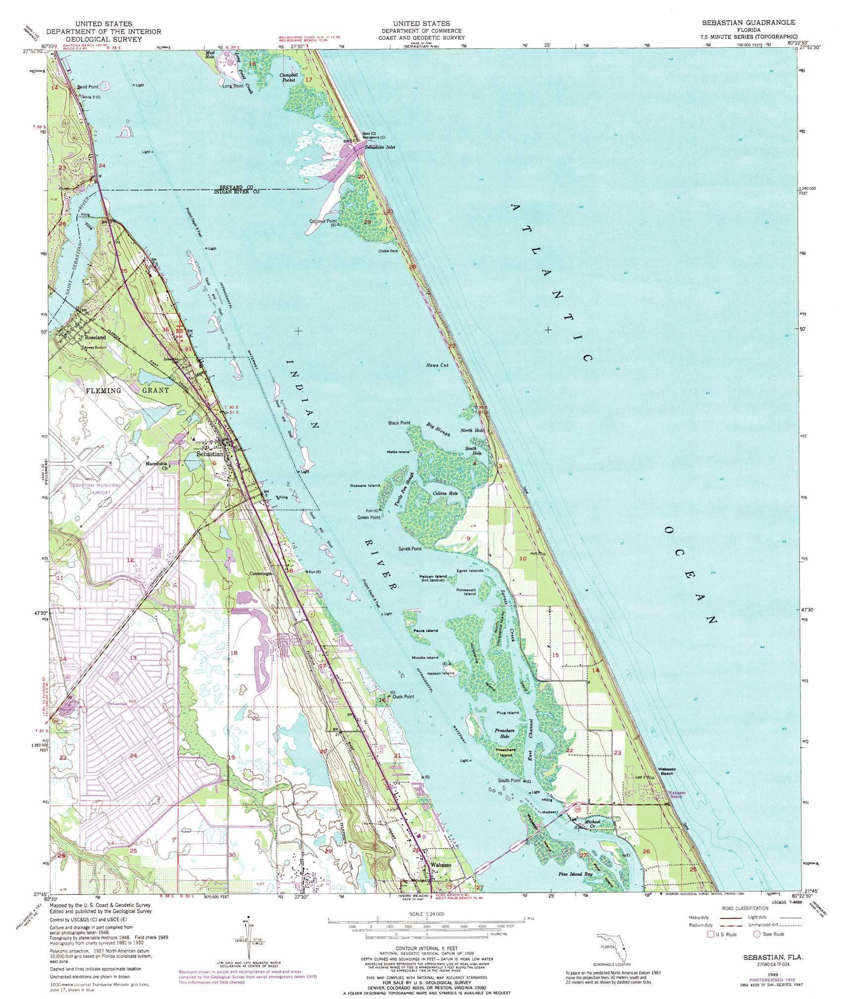
Sebastian Topo Map Florida
To zoom in, hover over the map of Sebastian
USGS Topo Quad 27080g4 - 1:24,000 scale
| Topo Map Name: | Sebastian |
| USGS Topo Quad ID: | 27080g4 |
| Print Size: | ca. 21 1/4" wide x 27" high |
| Southeast Coordinates: | 27.75° N latitude / 80.375° W longitude |
| Map Center Coordinates: | 27.8125° N latitude / 80.4375° W longitude |
| U.S. State: | FL |
| Filename: | O27080G4.jpg |
| Download Map JPG Image: | Sebastian topo map 1:24,000 scale |
| Map Type: | Topographic |
| Topo Series: | 7.5´ |
| Map Scale: | 1:24,000 |
| Source of Map Images: | United States Geological Survey (USGS) |
| Alternate Map Versions: |
Sebastian FL 1949, updated 1960 Download PDF Buy paper map Sebastian FL 1949, updated 1967 Download PDF Buy paper map Sebastian FL 1949, updated 1971 Download PDF Buy paper map Sebastian FL 1949, updated 1975 Download PDF Buy paper map Sebastian FL 1949, updated 1990 Download PDF Buy paper map Sebastian FL 1951 Download PDF Buy paper map Sebastian FL 2012 Download PDF Buy paper map Sebastian FL 2015 Download PDF Buy paper map |
1:24,000 Topo Quads surrounding Sebastian
Melbourne West |
Melbourne East |
|||
Fellsmere Nw |
Grant |
Sebastian Nw |
||
Fellsmere Sw |
Fellsmere |
Sebastian |
||
Fellsmere 4 Nw |
Fellsmere 4 Ne |
Vero Beach |
Riomar |
|
Fellsmere 4 Sw |
Fellsmere 4 Se |
Oslo |
Indrio |
> Back to 27080e1 at 1:100,000 scale
> Back to 27080a1 at 1:250,000 scale
> Back to U.S. Topo Maps home
Sebastian topo map: Gazetteer
Sebastian: Airports
Sebastian Municipal Airport elevation 6m 19′Sebastian: Bays
Campbell Pocket elevation 0m 0′News Cut elevation 0m 0′
Sebastian: Beaches
Wabasso Beach elevation 3m 9′Sebastian: Capes
Black Point elevation 0m 0′Coconut Point elevation 0m 0′
Duck Point elevation 0m 0′
Green Point elevation 0m 0′
Long Point elevation 0m 0′
Sand Point elevation 2m 6′
South Point elevation 0m 0′
Spratt Point elevation 0m 0′
Sebastian: Channels
East Channel elevation 0m 0′Sebastian Inlet elevation 0m 0′
Sebastian: Guts
Big Slough elevation 0m 0′Collins Hole elevation 0m 0′
Long Point Creek elevation 0m 0′
Michael Creek elevation 0m 0′
North Hole elevation 0m 0′
Pine Island Bay elevation 0m 0′
Preachers Hole elevation 0m 0′
South Hole elevation 0m 0′
Spratt Creek elevation 0m 0′
Turtle Pen Slough elevation 0m 0′
Sebastian: Islands
David Island elevation 0m 0′Egret Islands elevation 0m 0′
Horseshoe Island elevation 0m 0′
Long Island elevation 0m 0′
Melba Island elevation 0m 0′
Michael Island elevation 0m 0′
Middle Island elevation 0m 0′
Nelson Island elevation 0m 0′
North Horseshoe Island elevation 0m 0′
North Oyster Island elevation 0m 0′
Orchid Island elevation 0m 0′
Pauls Island elevation 0m 0′
Pelican Island elevation 0m 0′
Plug Island elevation 0m 0′
Preachers Island elevation 0m 0′
Roosevelt Island elevation 0m 0′
Roseate Island elevation 0m 0′
Snake Island elevation 0m 0′
South Oyster Island elevation 0m 0′
Wabasso Island elevation 0m 0′
Sebastian: Parks
Indian River-Malabar to Sebastian Aquatic Preserve elevation 0m 0′Pelican Island National Wildlife Refuge elevation 0m 0′
Sebastian Inlet State Park elevation 1m 3′
Sebastian: Populated Places
Breezeway Mobile Home Park elevation 4m 13′Crab Cove Mobile Home Park elevation 1m 3′
Cummings elevation 6m 19′
Dun Runnin Park Mobile Home Park elevation 1m 3′
El Capitan Mobile Home Park elevation 2m 6′
Fischer's Corner Trailer Park elevation 3m 9′
Karrs Riverland Mobile Home Park elevation 1m 3′
North Beach elevation 2m 6′
Orchid elevation 0m 0′
Palm Lake Club Mobile Home Park elevation 11m 36′
Park Place Mobile Home Park elevation 7m 22′
Pelican Bay Manufactured Home Community elevation 7m 22′
Pelican's Landing of Sebastian Mobile Home Park elevation 1m 3′
Roseland elevation 6m 19′
Sand Hill Mobile Home Park elevation 8m 26′
Sebastian elevation 6m 19′
Shady Rest Mobile Home Park elevation 6m 19′
Sunset Mobile Home Park elevation 3m 9′
Wabasso Beach elevation 3m 9′
Whispering Palms Mobile Village elevation 4m 13′
Sebastian: Post Offices
Sebastian Post Office elevation 5m 16′Sebastian: Streams
North Prong Saint Sebastian River elevation 0m 0′Saint Sebastian River elevation 0m 0′
South Prong Saint Sebastian River elevation 0m 0′
Sebastian digital topo map on disk
Buy this Sebastian topo map showing relief, roads, GPS coordinates and other geographical features, as a high-resolution digital map file on DVD: