Sebastian Nw Topo Map Florida
To zoom in, hover over the map of Sebastian Nw
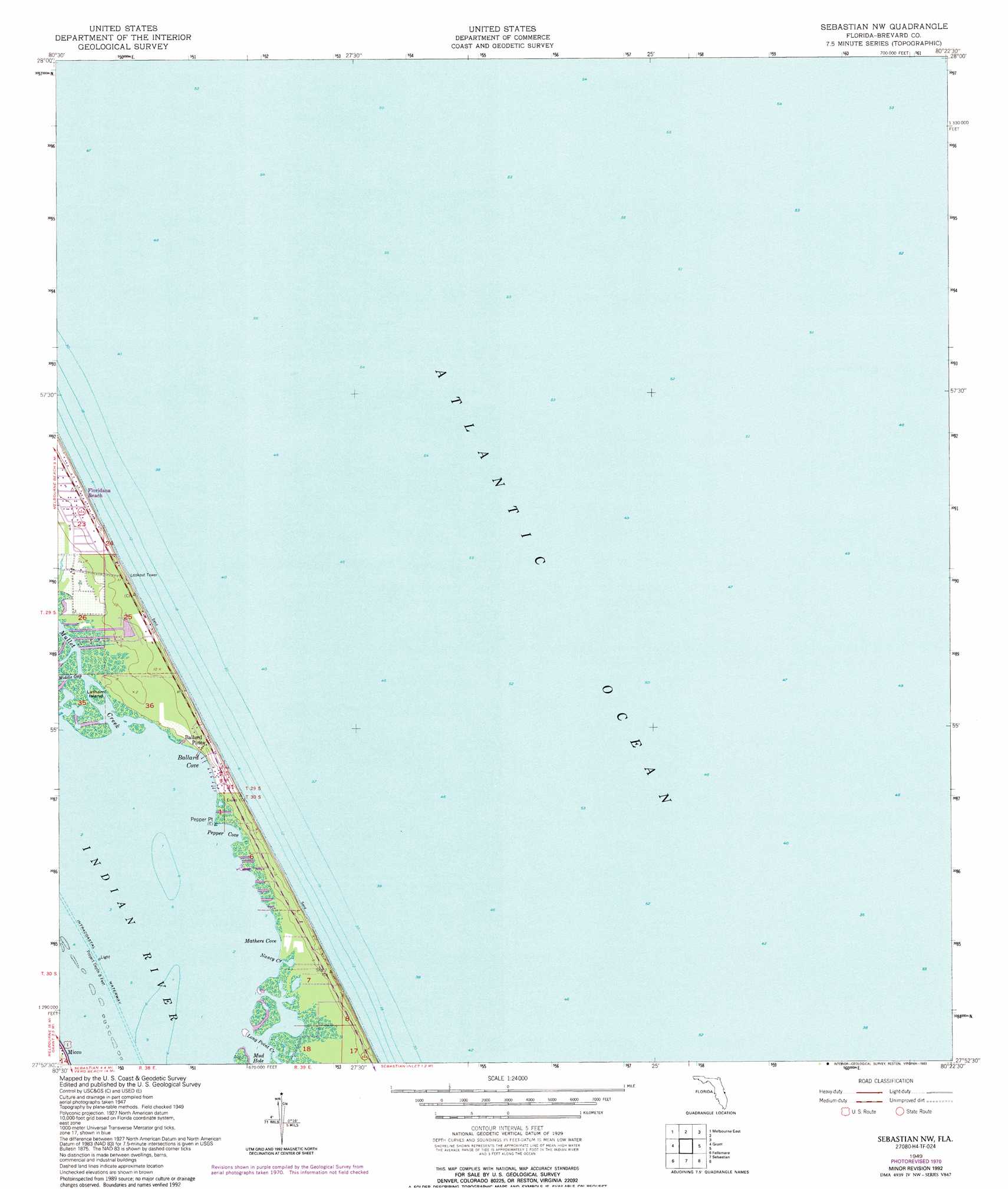
USGS Topo Quad 27080h4 - 1:24,000 scale
| Topo Map Name: | Sebastian Nw |
| USGS Topo Quad ID: | 27080h4 |
| Print Size: | ca. 21 1/4" wide x 27" high |
| Southeast Coordinates: | 27.875° N latitude / 80.375° W longitude |
| Map Center Coordinates: | 27.9375° N latitude / 80.4375° W longitude |
| U.S. State: | FL |
| Filename: | O27080H4.jpg |
| Download Map JPG Image: | Sebastian Nw topo map 1:24,000 scale |
| Map Type: | Topographic |
| Topo Series: | 7.5´ |
| Map Scale: | 1:24,000 |
| Source of Map Images: | United States Geological Survey (USGS) |
| Alternate Map Versions: |
Sebastian NW FL 1949, updated 1960 Download PDF Buy paper map Sebastian NW FL 1949, updated 1967 Download PDF Buy paper map Sebastian NW FL 1949, updated 1971 Download PDF Buy paper map Sebastian NW FL 1949, updated 1977 Download PDF Buy paper map Sebastian NW FL 1949, updated 1993 Download PDF Buy paper map Sebastian NW FL 1951 Download PDF Buy paper map Sebastian NW FL 2012 Download PDF Buy paper map Sebastian NW FL 2015 Download PDF Buy paper map |
1:24,000 Topo Quads surrounding Sebastian Nw
Eau Gallie |
Tropic |
|||
Melbourne West |
Melbourne East |
|||
Fellsmere Nw |
Grant |
Sebastian Nw |
||
Fellsmere Sw |
Fellsmere |
Sebastian |
||
Fellsmere 4 Nw |
Fellsmere 4 Ne |
Vero Beach |
Riomar |
> Back to 27080e1 at 1:100,000 scale
> Back to 27080a1 at 1:250,000 scale
> Back to U.S. Topo Maps home
Sebastian Nw topo map: Gazetteer
Sebastian Nw: Airports
Fulton Seaplane Base elevation 0m 0′Sebastian Nw: Bays
Ballard Cove elevation 0m 0′Mathers Cove elevation 0m 0′
Mud Hole elevation 0m 0′
Pepper Cove elevation 0m 0′
Sebastian Nw: Capes
Pepper Point elevation 0m 0′Sebastian Nw: Guts
Middle Gap elevation 0m 0′Mullet Creek elevation 0m 0′
Sebastian Nw: Islands
Latham Island elevation 0m 0′Sebastian Nw: Populated Places
Ballard Pines elevation 2m 6′Evans Pines elevation 0m 0′
Floridana Beach elevation 0m 0′
Sebastian Nw: Streams
Nancy Creek elevation 0m 0′Sebastian Nw digital topo map on disk
Buy this Sebastian Nw topo map showing relief, roads, GPS coordinates and other geographical features, as a high-resolution digital map file on DVD: