Arcadia Topo Map Florida
To zoom in, hover over the map of Arcadia
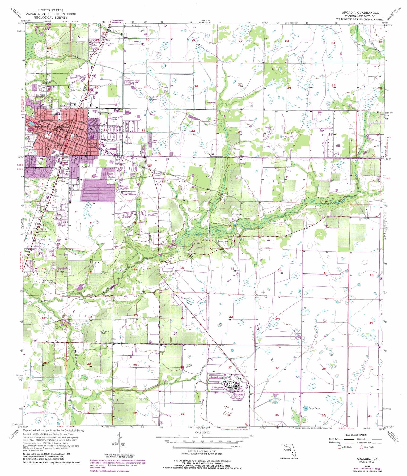
USGS Topo Quad 27081b7 - 1:24,000 scale
| Topo Map Name: | Arcadia |
| USGS Topo Quad ID: | 27081b7 |
| Print Size: | ca. 21 1/4" wide x 27" high |
| Southeast Coordinates: | 27.125° N latitude / 81.75° W longitude |
| Map Center Coordinates: | 27.1875° N latitude / 81.8125° W longitude |
| U.S. State: | FL |
| Filename: | O27081B7.jpg |
| Download Map JPG Image: | Arcadia topo map 1:24,000 scale |
| Map Type: | Topographic |
| Topo Series: | 7.5´ |
| Map Scale: | 1:24,000 |
| Source of Map Images: | United States Geological Survey (USGS) |
| Alternate Map Versions: |
Arcadia FL 1957, updated 1958 Download PDF Buy paper map Arcadia FL 1957, updated 1971 Download PDF Buy paper map Arcadia FL 1957, updated 1973 Download PDF Buy paper map Arcadia FL 1957, updated 1988 Download PDF Buy paper map Arcadia FL 2012 Download PDF Buy paper map Arcadia FL 2015 Download PDF Buy paper map |
1:24,000 Topo Quads surrounding Arcadia
Myakka Head |
Ona |
Zolfo Springs |
Sweetwater |
Crewsville |
Edgeville |
Limestone |
Gardner |
Crewsville Sw |
Crewsville Se |
Murdock Ne |
Nocatee |
Arcadia |
Long Island Marsh Nw |
Long Island Marsh Ne |
Murdock Se |
Fort Ogden |
Arcadia Se |
Long Island Marsh Sw |
Long Island Marsh Se |
Punta Gorda |
Cleveland |
Bermont |
Telegraph Swamp Nw |
Telegraph Swamp Ne |
> Back to 27081a1 at 1:100,000 scale
> Back to 27080a1 at 1:250,000 scale
> Back to U.S. Topo Maps home
Arcadia topo map: Gazetteer
Arcadia: Airports
Arcadia Municipal Airport elevation 17m 55′De Soto Aircraft Field elevation 16m 52′
De Soto Memorial Hospital Heliport elevation 20m 65′
Arcadia: Bridges
Chesterfield Smith Bridge elevation 8m 26′Arcadia: Lakes
Deep Lake elevation 17m 55′Lake Katherine elevation 9m 29′
Arcadia: Populated Places
Arcadia elevation 18m 59′Arcadia Municipal Mobile Home Park elevation 16m 52′
Lazy Bee Mobile Home Park elevation 13m 42′
Lindale Mobile Home Park elevation 14m 45′
Little Gator Park Mobile Home Park elevation 14m 45′
Oakview Mobile Home Estates elevation 20m 65′
Sunrise Mobile Home Park elevation 18m 59′
Arcadia: Post Offices
Arcadia Post Office elevation 18m 59′Arcadia: Streams
Hawthorne Creek elevation 4m 13′Arcadia digital topo map on disk
Buy this Arcadia topo map showing relief, roads, GPS coordinates and other geographical features, as a high-resolution digital map file on DVD: