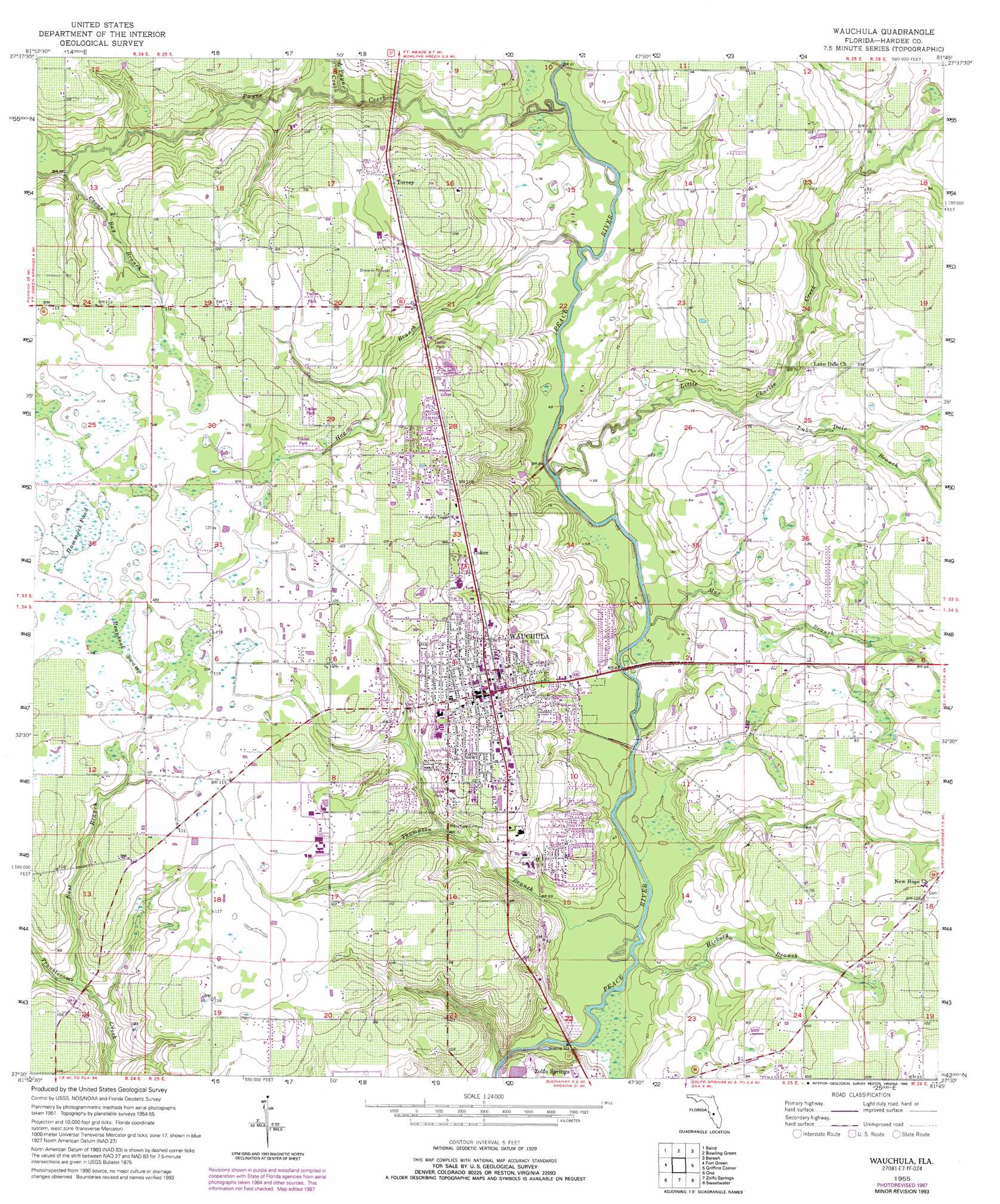
Wauchula Topo Map Florida
To zoom in, hover over the map of Wauchula
USGS Topo Quad 27081e7 - 1:24,000 scale
| Topo Map Name: | Wauchula |
| USGS Topo Quad ID: | 27081e7 |
| Print Size: | ca. 21 1/4" wide x 27" high |
| Southeast Coordinates: | 27.5° N latitude / 81.75° W longitude |
| Map Center Coordinates: | 27.5625° N latitude / 81.8125° W longitude |
| U.S. State: | FL |
| Filename: | O27081E7.jpg |
| Download Map JPG Image: | Wauchula topo map 1:24,000 scale |
| Map Type: | Topographic |
| Topo Series: | 7.5´ |
| Map Scale: | 1:24,000 |
| Source of Map Images: | United States Geological Survey (USGS) |
| Alternate Map Versions: |
Wauchula FL 1955, updated 1956 Download PDF Buy paper map Wauchula FL 1955, updated 1983 Download PDF Buy paper map Wauchula FL 1955, updated 1988 Download PDF Buy paper map Wauchula FL 1955, updated 1993 Download PDF Buy paper map Wauchula FL 2012 Download PDF Buy paper map Wauchula FL 2015 Download PDF Buy paper map |
1:24,000 Topo Quads surrounding Wauchula
Keysville |
Bradley Junction |
Homeland |
Alturas |
Babson Park |
Duette Ne |
Baird |
Bowling Green |
Bereah |
Frostproof |
Duette |
Fort Green |
Wauchula |
Griffins Corner |
Avon Park |
Myakka Head |
Ona |
Zolfo Springs |
Sweetwater |
Crewsville |
Edgeville |
Limestone |
Gardner |
Crewsville Sw |
Crewsville Se |
> Back to 27081e1 at 1:100,000 scale
> Back to 27080a1 at 1:250,000 scale
> Back to U.S. Topo Maps home
Wauchula topo map: Gazetteer
Wauchula: Bridges
Doyle E Carlton Bridge elevation 11m 36′Wauchula: Populated Places
Citrus Valley Mobile Home Estates elevation 26m 85′Coker elevation 37m 121′
Crystal Lake Mobile Home Park elevation 33m 108′
Torrey elevation 33m 108′
Wauchula elevation 34m 111′
Wauchula Hills elevation 35m 114′
Wauchula: Post Offices
Wauchula Post Office elevation 32m 104′Wauchula: Streams
Coons Bay Branch elevation 22m 72′East Branch Troublesome Creek elevation 22m 72′
Hickory Branch elevation 13m 42′
Hog Branch elevation 15m 49′
Lake Dale Branch elevation 18m 59′
Little Charlie Creek elevation 15m 49′
Little Payne Creek elevation 18m 59′
Max Branch elevation 15m 49′
Payne Creek elevation 16m 52′
Thompson Branch elevation 12m 39′
Wauchula: Swamps
Hammock Pond elevation 35m 114′Reaphook Swamp elevation 35m 114′
Wauchula digital topo map on disk
Buy this Wauchula topo map showing relief, roads, GPS coordinates and other geographical features, as a high-resolution digital map file on DVD: