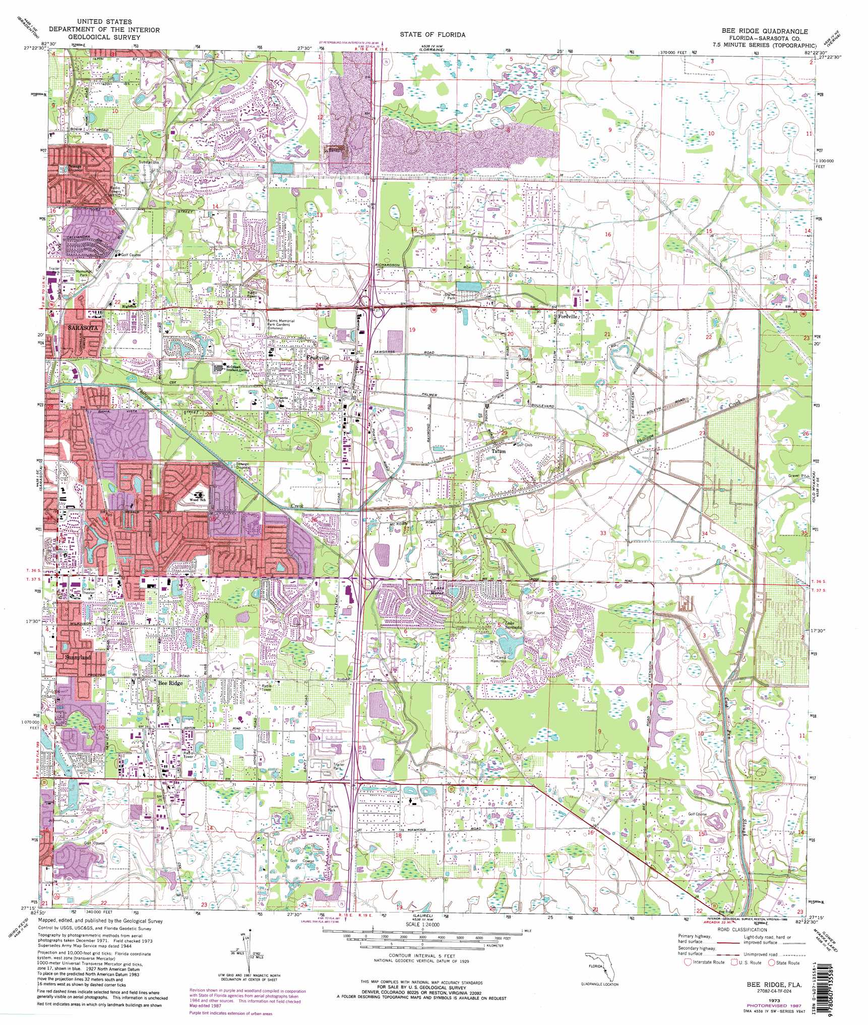
Bee Ridge Topo Map Florida
To zoom in, hover over the map of Bee Ridge
USGS Topo Quad 27082c4 - 1:24,000 scale
| Topo Map Name: | Bee Ridge |
| USGS Topo Quad ID: | 27082c4 |
| Print Size: | ca. 21 1/4" wide x 27" high |
| Southeast Coordinates: | 27.25° N latitude / 82.375° W longitude |
| Map Center Coordinates: | 27.3125° N latitude / 82.4375° W longitude |
| U.S. State: | FL |
| Filename: | O27082C4.jpg |
| Download Map JPG Image: | Bee Ridge topo map 1:24,000 scale |
| Map Type: | Topographic |
| Topo Series: | 7.5´ |
| Map Scale: | 1:24,000 |
| Source of Map Images: | United States Geological Survey (USGS) |
| Alternate Map Versions: |
Bee Ridge FL 1947 Download PDF Buy paper map Bee Ridge FL 1947, updated 1968 Download PDF Buy paper map Bee Ridge FL 1973, updated 1975 Download PDF Buy paper map Bee Ridge FL 1973, updated 1988 Download PDF Buy paper map Bee Ridge FL 1973, updated 1988 Download PDF Buy paper map Bee Ridge FL 2012 Download PDF Buy paper map Bee Ridge FL 2015 Download PDF Buy paper map |
1:24,000 Topo Quads surrounding Bee Ridge
Anna Maria |
Palmetto |
Parrish |
Rye |
Keentown |
Bradenton Beach |
Bradenton |
Lorraine |
Verna |
Myakka City Nw |
Sarasota |
Bee Ridge |
Old Myakka |
Myakka City |
|
Bird Keys |
Laurel |
Lower Myakka Lake |
Murdock Nw |
|
Venice |
Myakka River |
Murdock |
> Back to 27082a1 at 1:100,000 scale
> Back to 27082a1 at 1:250,000 scale
> Back to U.S. Topo Maps home
Bee Ridge topo map: Gazetteer
Bee Ridge: Airports
Gator Creek Airport elevation 9m 29′Sarasota Department of Fire-Rescue East Side Heliport elevation 5m 16′
Bee Ridge: Lakes
Lake Clark elevation 5m 16′Lake Marae elevation 10m 32′
Lake Sarasota elevation 8m 26′
Bee Ridge: Populated Places
Bee Ridge elevation 10m 32′Belspur elevation 9m 29′
Desoto Lakes elevation 9m 29′
Fordville elevation 12m 39′
Fruitville elevation 9m 29′
Hyde Park elevation 6m 19′
Kensington Park elevation 6m 19′
Lake Sarasota elevation 9m 29′
Pinecraft elevation 4m 13′
Sarasota Springs elevation 7m 22′
South Gate Ridge elevation 9m 29′
Sunnyland elevation 10m 32′
Sunrise elevation 11m 36′
Tatum elevation 7m 22′
Tatum Ridge elevation 10m 32′
The Meadows elevation 8m 26′
Bee Ridge: Reservoirs
Alligator Pond elevation 6m 19′Lake Ibis elevation 6m 19′
Bee Ridge digital topo map on disk
Buy this Bee Ridge topo map showing relief, roads, GPS coordinates and other geographical features, as a high-resolution digital map file on DVD: