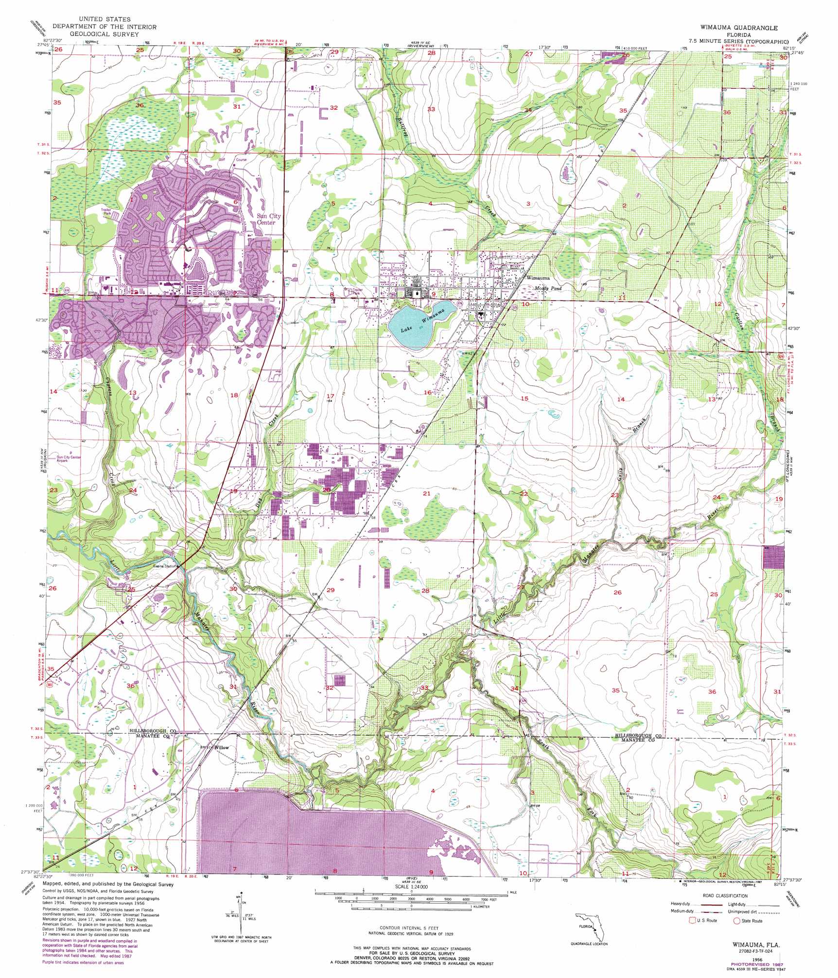
Wimauma Topo Map Florida
To zoom in, hover over the map of Wimauma
USGS Topo Quad 27082f3 - 1:24,000 scale
| Topo Map Name: | Wimauma |
| USGS Topo Quad ID: | 27082f3 |
| Print Size: | ca. 21 1/4" wide x 27" high |
| Southeast Coordinates: | 27.625° N latitude / 82.25° W longitude |
| Map Center Coordinates: | 27.6875° N latitude / 82.3125° W longitude |
| U.S. State: | FL |
| Filename: | O27082F3.jpg |
| Download Map JPG Image: | Wimauma topo map 1:24,000 scale |
| Map Type: | Topographic |
| Topo Series: | 7.5´ |
| Map Scale: | 1:24,000 |
| Source of Map Images: | United States Geological Survey (USGS) |
| Alternate Map Versions: |
Wimauma FL 1956, updated 1957 Download PDF Buy paper map Wimauma FL 1956, updated 1970 Download PDF Buy paper map Wimauma FL 1956, updated 1982 Download PDF Buy paper map Wimauma FL 1956, updated 1987 Download PDF Buy paper map Wimauma FL 2012 Download PDF Buy paper map Wimauma FL 2015 Download PDF Buy paper map |
1:24,000 Topo Quads surrounding Wimauma
Gandy Bridge |
Tampa |
Brandon |
Dover |
Nichols |
Port Tampa |
Gibsonton |
Riverview |
Lithia |
Keysville |
Cockroach Bay |
Ruskin |
Wimauma |
Fort Lonesome |
Duette Ne |
Palmetto |
Parrish |
Rye |
Keentown |
Duette |
Bradenton |
Lorraine |
Verna |
Myakka City Nw |
Myakka Head |
> Back to 27082e1 at 1:100,000 scale
> Back to 27082a1 at 1:250,000 scale
> Back to U.S. Topo Maps home
Wimauma topo map: Gazetteer
Wimauma: Airports
Wimauma Air Park elevation 32m 104′Wimauma: Lakes
Lake Wimauma elevation 26m 85′Moody Pond elevation 32m 104′
Wimauma: Parks
Little Manatee River State Park elevation 4m 13′Wimauma: Populated Places
Amberwave Estates elevation 33m 108′Arbors at Freedom Plaza elevation 10m 32′
Balm Gardens elevation 35m 114′
Bringers Saffold Ranchettes elevation 17m 55′
Caloosa elevation 15m 49′
Caloosa Country Club Estates elevation 14m 45′
Camacho elevation 20m 65′
Carlton Branch elevation 23m 75′
Carmuchas elevation 17m 55′
Club Manor elevation 18m 59′
Cypress Park elevation 10m 32′
Cypressview elevation 11m 36′
Dell Vista elevation 18m 59′
Flores elevation 7m 22′
Freedom Village elevation 11m 36′
Gantree elevation 19m 62′
Glengarry Green elevation 25m 82′
Greenbriar elevation 16m 52′
Jones elevation 31m 101′
Kings elevation 16m 52′
Lake View elevation 28m 91′
Lake Wimauma elevation 27m 88′
Little Manatee River Estates elevation 8m 26′
Morris Park Farms elevation 22m 72′
Nettlow elevation 16m 52′
North Green Estates elevation 15m 49′
Orendain elevation 27m 88′
Pippin Estates elevation 6m 19′
Pippin Farms elevation 9m 29′
Pippins elevation 7m 22′
Puentes elevation 14m 45′
Ramirez Estates elevation 19m 62′
Ranch Lands elevation 18m 59′
Riverranch Preserve elevation 20m 65′
Saffold Estates elevation 6m 19′
Scarboro elevation 29m 95′
Southwind elevation 15m 49′
Stansell elevation 29m 95′
Summerfield Wimauma elevation 23m 75′
Sun City Center elevation 15m 49′
Sun Lakes elevation 13m 42′
Sweat Farms elevation 35m 114′
The Knolls of Kings Point elevation 8m 26′
Valencia Lakes elevation 21m 68′
Ventana North elevation 14m 45′
West Green Estates elevation 15m 49′
West Lake Farms elevation 25m 82′
Willow elevation 15m 49′
Willow Shores elevation 2m 6′
Wimauma elevation 31m 101′
Yorkshire elevation 12m 39′
Wimauma: Post Offices
Wimauma Post Office elevation 28m 91′Wimauma: Streams
Carlton Branch elevation 10m 32′Cypress Creek elevation 1m 3′
Dug Creek elevation 1m 3′
Gully Branch elevation 7m 22′
South Fork Little Manatee River elevation 7m 22′
Wimauma digital topo map on disk
Buy this Wimauma topo map showing relief, roads, GPS coordinates and other geographical features, as a high-resolution digital map file on DVD: