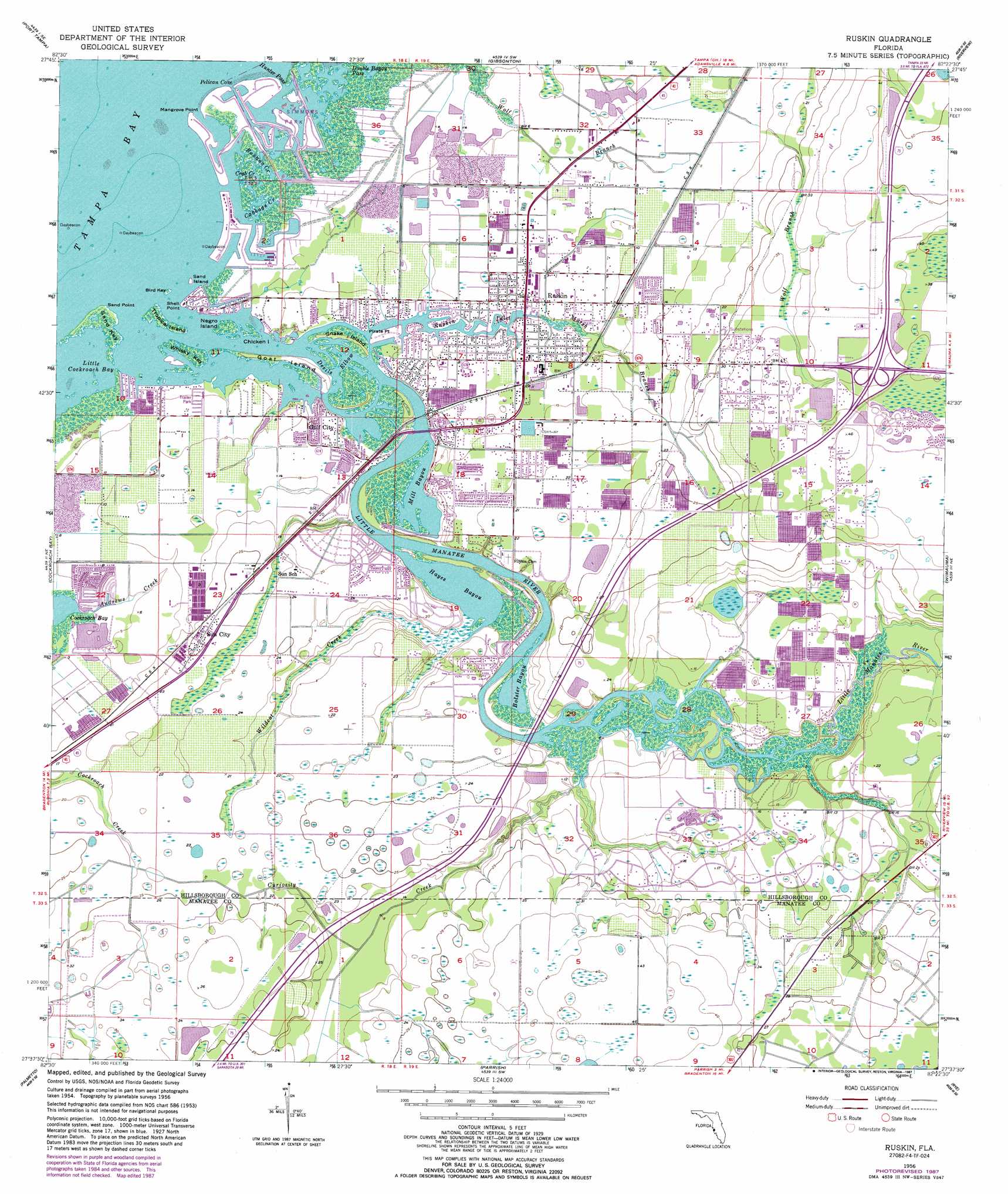
Ruskin Topo Map Florida
To zoom in, hover over the map of Ruskin
USGS Topo Quad 27082f4 - 1:24,000 scale
| Topo Map Name: | Ruskin |
| USGS Topo Quad ID: | 27082f4 |
| Print Size: | ca. 21 1/4" wide x 27" high |
| Southeast Coordinates: | 27.625° N latitude / 82.375° W longitude |
| Map Center Coordinates: | 27.6875° N latitude / 82.4375° W longitude |
| U.S. State: | FL |
| Filename: | O27082F4.jpg |
| Download Map JPG Image: | Ruskin topo map 1:24,000 scale |
| Map Type: | Topographic |
| Topo Series: | 7.5´ |
| Map Scale: | 1:24,000 |
| Source of Map Images: | United States Geological Survey (USGS) |
| Alternate Map Versions: |
Ruskin FL 1956, updated 1957 Download PDF Buy paper map Ruskin FL 1956, updated 1970 Download PDF Buy paper map Ruskin FL 1956, updated 1982 Download PDF Buy paper map Ruskin FL 1956, updated 1987 Download PDF Buy paper map Ruskin FL 2012 Download PDF Buy paper map Ruskin FL 2015 Download PDF Buy paper map |
1:24,000 Topo Quads surrounding Ruskin
Safety Harbor |
Gandy Bridge |
Tampa |
Brandon |
Dover |
Saint Petersburg |
Port Tampa |
Gibsonton |
Riverview |
Lithia |
Pass-A-Grille Beach |
Cockroach Bay |
Ruskin |
Wimauma |
Fort Lonesome |
Anna Maria |
Palmetto |
Parrish |
Rye |
Keentown |
Bradenton Beach |
Bradenton |
Lorraine |
Verna |
Myakka City Nw |
> Back to 27082e1 at 1:100,000 scale
> Back to 27082a1 at 1:250,000 scale
> Back to U.S. Topo Maps home
Ruskin topo map: Gazetteer
Ruskin: Airports
Bahia Beach Heliport elevation 0m 0′Ruskin: Bays
Bolster Bayou elevation 0m 0′Hayes Bayou elevation 0m 0′
Mill Bayou elevation 0m 0′
Pelican Cove elevation 0m 0′
Ruskin: Beaches
Bahia Beach elevation 0m 0′Ruskin: Bends
Devils Elbow elevation 0m 0′Ruskin: Capes
Mangrove Point elevation 0m 0′Pirate Point elevation 0m 0′
Sand Point elevation 0m 0′
Ruskin: Channels
Hunter Pass elevation 0m 0′Ruskin: Crossings
Interchange 240 elevation 12m 39′Ruskin: Guts
Double Bayou Pass elevation 0m 0′Ruskin Inlet elevation 0m 0′
Ruskin: Islands
Bird Key elevation 0m 0′Chicken Island elevation 0m 0′
Goat Island elevation 0m 0′
Negro Island elevation 0m 0′
Sand Island elevation 0m 0′
Sand Key elevation 0m 0′
Snake Island elevation 0m 0′
Tropical Island elevation 0m 0′
Whiskey Key elevation 0m 0′
Ruskin: Populated Places
Amanda elevation 5m 16′Bahia Beach elevation 0m 0′
Bayou Pass Village elevation 11m 36′
Blackstone at Bay Park elevation 4m 13′
Braemar elevation 1m 3′
Byrd Acres elevation 6m 19′
Calusa Bay elevation 1m 3′
Campus Shores elevation 1m 3′
Careys Pirate Point elevation 0m 0′
Chalaiman Estates elevation 5m 16′
College Chase elevation 4m 13′
Collura elevation 0m 0′
Covina at Bay Park elevation 3m 9′
Cypress Creek Village elevation 14m 45′
Doerr elevation 0m 0′
Elizabeth Acres elevation 6m 19′
Fairmont Mobile Estates elevation 4m 13′
Fairmont Park elevation 4m 13′
Flournoy elevation 12m 39′
Gaudys Paradise elevation 3m 9′
Green Acres elevation 2m 6′
Gulf City elevation 3m 9′
Gull Haven elevation 0m 0′
Hamton elevation 2m 6′
Harbour Isles elevation 2m 6′
Kims Cove elevation 0m 0′
Leon elevation 7m 22′
Lillie Estates elevation 2m 6′
Little Manatee Heights elevation 6m 19′
Lost River Preserve elevation 2m 6′
Manatee Harbor elevation 1m 3′
Maplewood elevation 8m 26′
Marquette elevation 12m 39′
Mays elevation 4m 13′
Mill Highlands elevation 4m 13′
Mira Lago West elevation 1m 3′
Montero Village elevation 11m 36′
Myrtle Tree elevation 10m 32′
Netherland elevation 1m 3′
North Branch Shores elevation 1m 3′
Onstott Acres elevation 3m 9′
Park Village elevation 7m 22′
Pelican Point elevation 2m 6′
Pirates Point elevation 0m 0′
Point Heron elevation 0m 0′
River Bend elevation 7m 22′
River Oaks elevation 1m 3′
River Shore Farms elevation 1m 3′
Rowell elevation 4m 13′
Rowell Place elevation 4m 13′
Ruskin elevation 1m 3′
Ruskin Colony Estates elevation 11m 36′
Ruskin Colony Farms elevation 2m 6′
Ruskin Inlet elevation 0m 0′
Sable Cove elevation 1m 3′
Saffold Park elevation 3m 9′
Sanctuary Estates elevation 5m 16′
Sandpiper Point elevation 0m 0′
Selnerville elevation 1m 3′
Sheron Lee Estates elevation 1m 3′
Shooks Folly elevation 11m 36′
Sill Manor elevation 3m 9′
Solitude elevation 1m 3′
Spyglass at River Bend elevation 6m 19′
Sun City elevation 8m 26′
Sundance elevation 5m 16′
Sundance Trails Phase 1 elevation 5m 16′
Thea Simmons elevation 2m 6′
Twin Lake elevation 4m 13′
Venetian at Bay Park elevation 2m 6′
Wellington North at Bay Park elevation 2m 6′
Wellington South at Bay Park elevation 5m 16′
Winding Creek elevation 4m 13′
Wolf Branch elevation 4m 13′
Ruskin: Streams
Andrews Creek elevation 0m 0′Banana Creek elevation 0m 0′
Cabbage Creek elevation 0m 0′
Crab Creek elevation 0m 0′
Curiosity Creek elevation 0m 0′
Little Manatee River elevation 0m 0′
Marsh Branch elevation 0m 0′
Wildcat Creek elevation 0m 0′
Ruskin digital topo map on disk
Buy this Ruskin topo map showing relief, roads, GPS coordinates and other geographical features, as a high-resolution digital map file on DVD: