Saint Petersburg Topo Map Florida
To zoom in, hover over the map of Saint Petersburg
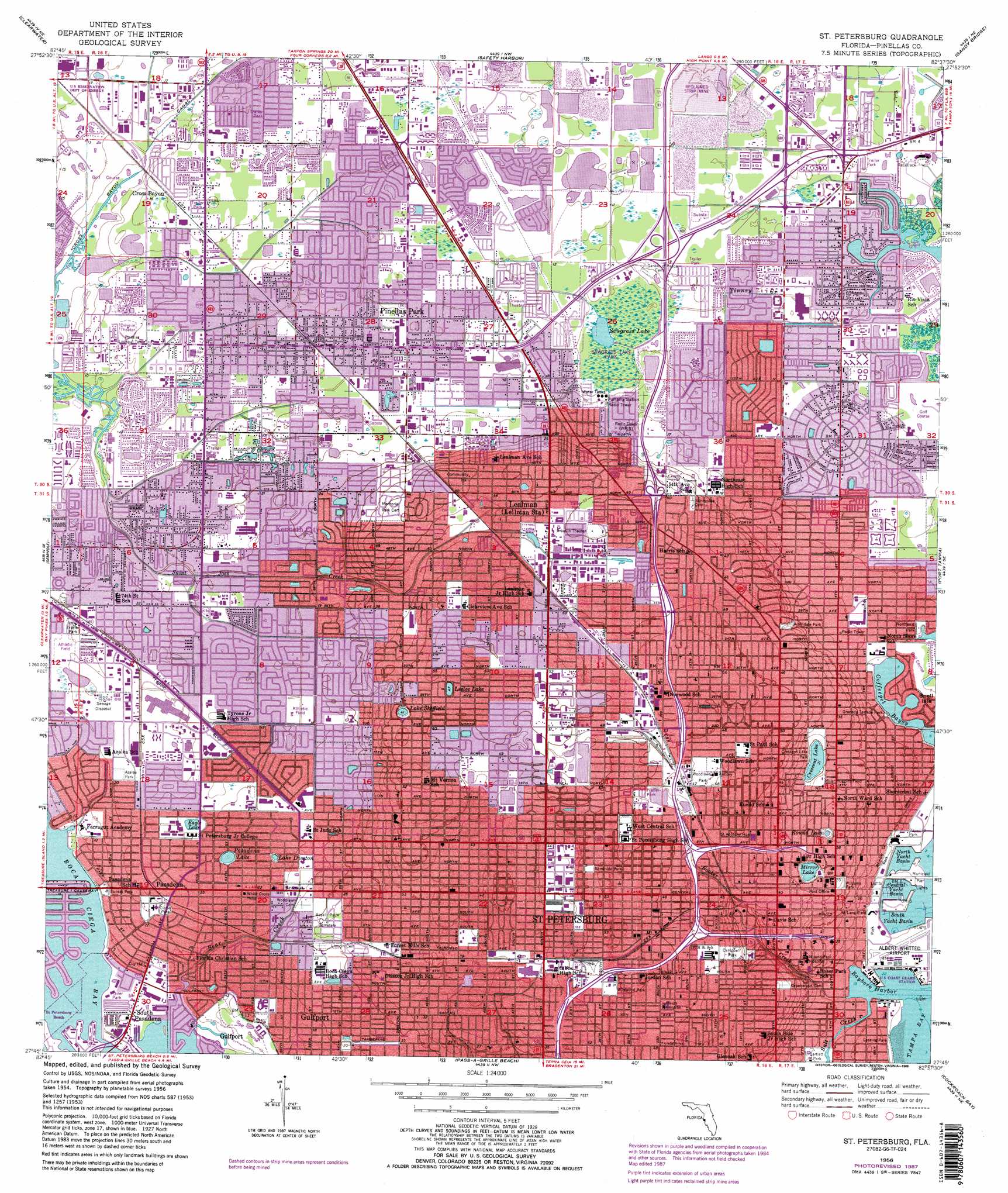
USGS Topo Quad 27082g6 - 1:24,000 scale
| Topo Map Name: | Saint Petersburg |
| USGS Topo Quad ID: | 27082g6 |
| Print Size: | ca. 21 1/4" wide x 27" high |
| Southeast Coordinates: | 27.75° N latitude / 82.625° W longitude |
| Map Center Coordinates: | 27.8125° N latitude / 82.6875° W longitude |
| U.S. State: | FL |
| Filename: | O27082G6.jpg |
| Download Map JPG Image: | Saint Petersburg topo map 1:24,000 scale |
| Map Type: | Topographic |
| Topo Series: | 7.5´ |
| Map Scale: | 1:24,000 |
| Source of Map Images: | United States Geological Survey (USGS) |
| Alternate Map Versions: |
St. Petersburg FL 1956, updated 1957 Download PDF Buy paper map St. Petersburg FL 1956, updated 1970 Download PDF Buy paper map St Petersburg FL 1956, updated 1982 Download PDF Buy paper map St Petersburg FL 1956, updated 1988 Download PDF Buy paper map St. Petersburg FL 1956, updated 1988 Download PDF Buy paper map Saint Petersburg FL 1998, updated 2001 Download PDF Buy paper map Saint Petersburg FL 2012 Download PDF Buy paper map Saint Petersburg FL 2015 Download PDF Buy paper map |
1:24,000 Topo Quads surrounding Saint Petersburg
Dunedin |
Oldsmar |
Citrus Park |
Sulphur Springs |
|
Clearwater |
Safety Harbor |
Gandy Bridge |
Tampa |
|
Seminole |
Saint Petersburg |
Port Tampa |
Gibsonton |
|
Pass-A-Grille Beach |
Cockroach Bay |
Ruskin |
||
Egmont Key |
Anna Maria |
Palmetto |
Parrish |
> Back to 27082e1 at 1:100,000 scale
> Back to 27082a1 at 1:250,000 scale
> Back to U.S. Topo Maps home
Saint Petersburg topo map: Gazetteer
Saint Petersburg: Airports
Albert Whitted Airport elevation 2m 6′Bayfront Medical Center Incorporated Heliport elevation 10m 32′
Saint Petersburg: Bays
Coffeepot Bayou elevation 0m 0′Saint Petersburg: Canals
Cross Bayou Canal elevation 5m 16′Saint Petersburg: Crossings
Interchange 19 elevation 12m 39′Interchange 20 elevation 15m 49′
Interchange 21 elevation 15m 49′
Interchange 23A elevation 13m 42′
Interchange 23B elevation 11m 36′
Interchange 24 elevation 16m 52′
Interchange 25 elevation 15m 49′
Interchange 26 elevation 15m 49′
Interchange 28 elevation 2m 6′
Saint Petersburg: Guts
Bear Creek elevation 2m 6′Tinney Creek elevation 1m 3′
Saint Petersburg: Harbors
Bayboro Harbor elevation 0m 0′Central Yacht Basin elevation 0m 0′
North Yacht Basin elevation 0m 0′
Port of Saint Petersburg elevation 0m 0′
South Yacht Basin elevation 0m 0′
Saint Petersburg: Islands
South Causeway Isles elevation 0m 0′Saint Petersburg: Lakes
Blue Heron Lake elevation 1m 3′Crescent Lake elevation 8m 26′
Eagle Lake elevation 6m 19′
Lake Disston elevation 6m 19′
Lake Sheffield elevation 13m 42′
Leslee Lake elevation 15m 49′
McKee Lake elevation 4m 13′
Mirror Lake elevation 8m 26′
Pasadena Lake elevation 6m 19′
Round Lake elevation 10m 32′
Sawgrass Lake elevation 2m 6′
Saint Petersburg: Parks
Albert Whitted Park elevation 1m 3′Allendale Park elevation 11m 36′
Azalea Park elevation 6m 19′
Barbara Gilberg Habitat elevation 1m 3′
Bartlett Park elevation 1m 3′
Barwood Park elevation 1m 3′
Baywood Park-Indian Midden elevation 4m 13′
Bear Creek Park elevation 5m 16′
Blanc Park elevation 16m 52′
Booker Creek Linear Park elevation 12m 39′
Booker Creek Park elevation 11m 36′
Broderick Recreation Center elevation 5m 16′
Caldwell Park elevation 3m 9′
Campbell Park elevation 12m 39′
Central Oak Park elevation 13m 42′
Childs Park elevation 9m 29′
Childs Park Linear elevation 8m 26′
Circle Park elevation 6m 19′
Coconut Park elevation 1m 3′
Crescent Lake Park elevation 9m 29′
Crisp Park elevation 1m 3′
Crisp Park elevation 1m 3′
Davis Field elevation 3m 9′
Demens Landing Park elevation 1m 3′
Disston Lake Park elevation 6m 19′
Duryea Park elevation 1m 3′
Dwight Jones Park elevation 14m 45′
Eaglecrest Lake elevation 6m 19′
Edgewater Waterfront Park elevation 2m 6′
Elva Rouse Park elevation 2m 6′
Enoch Davis Park elevation 12m 39′
Euclid Lake Park elevation 15m 49′
Forbes Recreation Center elevation 5m 16′
Fred Held Habitat elevation 0m 0′
Freedom Lake Park elevation 4m 13′
Galatea Garden elevation 1m 3′
Gizella Kopsick Palm Arboretum elevation 2m 6′
Gladden Park elevation 15m 49′
Golf Creek Park elevation 2m 6′
Granada Circle Park elevation 5m 16′
Granada Terrace Park elevation 1m 3′
Harbordale Park elevation 15m 49′
Harding Park elevation 1m 3′
Harshaw Lake Number 1 elevation 15m 49′
Historic Round Lake Park elevation 10m 32′
Huggins Stengel Baseball Complex elevation 9m 29′
International Park elevation 11m 36′
Island Drive Mini Park elevation 1m 3′
Jamestown Park elevation 14m 45′
Jorgenson Lake Park elevation 12m 39′
Kelly Lake Park elevation 13m 42′
Lake Pasadena Park elevation 6m 19′
Lassing Park elevation 1m 3′
Lloyd Tingler Park elevation 3m 9′
Louise Lake Park elevation 15m 49′
Lynch Lake Park elevation 1m 3′
Mastry Lake Park elevation 1m 3′
Maximo Park elevation 14m 45′
Maynard A Duryea Bay View Park elevation 1m 3′
Meadowlawn Park elevation 1m 3′
Millennium Youth Park Uptown Playlot elevation 12m 39′
North Central Neighborhood Park elevation 12m 39′
North Shore Park elevation 2m 6′
Northeast Exchange Coffee Pot Park elevation 1m 3′
Northwest Park elevation 4m 13′
Palmetto Park elevation 16m 52′
Park on Park elevation 2m 6′
Park Uptown Playlot Mirror Lake Park elevation 9m 29′
Pasadena Circle elevation 6m 19′
Pasadena Triangle elevation 2m 6′
Pioneer Park elevation 2m 6′
Playlot 1 elevation 14m 45′
Playlot 2 elevation 14m 45′
Playlot 3 elevation 13m 42′
Poynter Park elevation 1m 3′
Rio Vista Park elevation 1m 3′
Roberts Park elevation 6m 19′
Roser Park elevation 2m 6′
Sawgrass Lake Park elevation 2m 6′
Seminole Park elevation 16m 52′
Sheffield Lake Park elevation 12m 39′
Sirmons Lake Park elevation 15m 49′
Spa Beach Park elevation 1m 3′
Straub Park - North Downtown Waterfront Park elevation 2m 6′
Straub Park - South Soreno elevation 2m 6′
Sunhaven Lake Park elevation 5m 16′
Sunset Park elevation 2m 6′
Sylvia C Boring Park elevation 14m 45′
Tomlinson Park Complex elevation 6m 19′
Tropicana Field elevation 8m 26′
Tyrone Park elevation 4m 13′
Unity Park elevation 14m 45′
Vinoy Park elevation 2m 6′
Walter Fuller Park elevation 5m 16′
Wildwood Park elevation 15m 49′
Williams Park elevation 10m 32′
Wilmers Park elevation 10m 32′
Wood Park elevation 5m 16′
Woodlawn Park elevation 14m 45′
Youth Park elevation 6m 19′
Saint Petersburg: Populated Places
Cross Bayou elevation 4m 13′Kenneth City elevation 6m 19′
Lealman elevation 15m 49′
Pasadena elevation 6m 19′
Pinellas Park elevation 4m 13′
Rio Vista elevation 1m 3′
Saint Petersburg elevation 13m 42′
South Pasadena elevation 1m 3′
Totstalahoeetska (historical) elevation 1m 3′
Saint Petersburg: Post Offices
Central Saint Petersburg Post Office elevation 16m 52′Crossroads Post Office elevation 5m 16′
Euclid Post Office elevation 12m 39′
Gateway Mall Post Office elevation 1m 3′
Midtown Saint Petersburg Post Office elevation 13m 42′
Open Air Post Office elevation 10m 32′
Pinellas Park Post Office elevation 3m 9′
Saint Petersburg Post Office elevation 10m 32′
Saint Petersburg: Streams
Booker Creek elevation 0m 0′Saint Petersburg digital topo map on disk
Buy this Saint Petersburg topo map showing relief, roads, GPS coordinates and other geographical features, as a high-resolution digital map file on DVD: