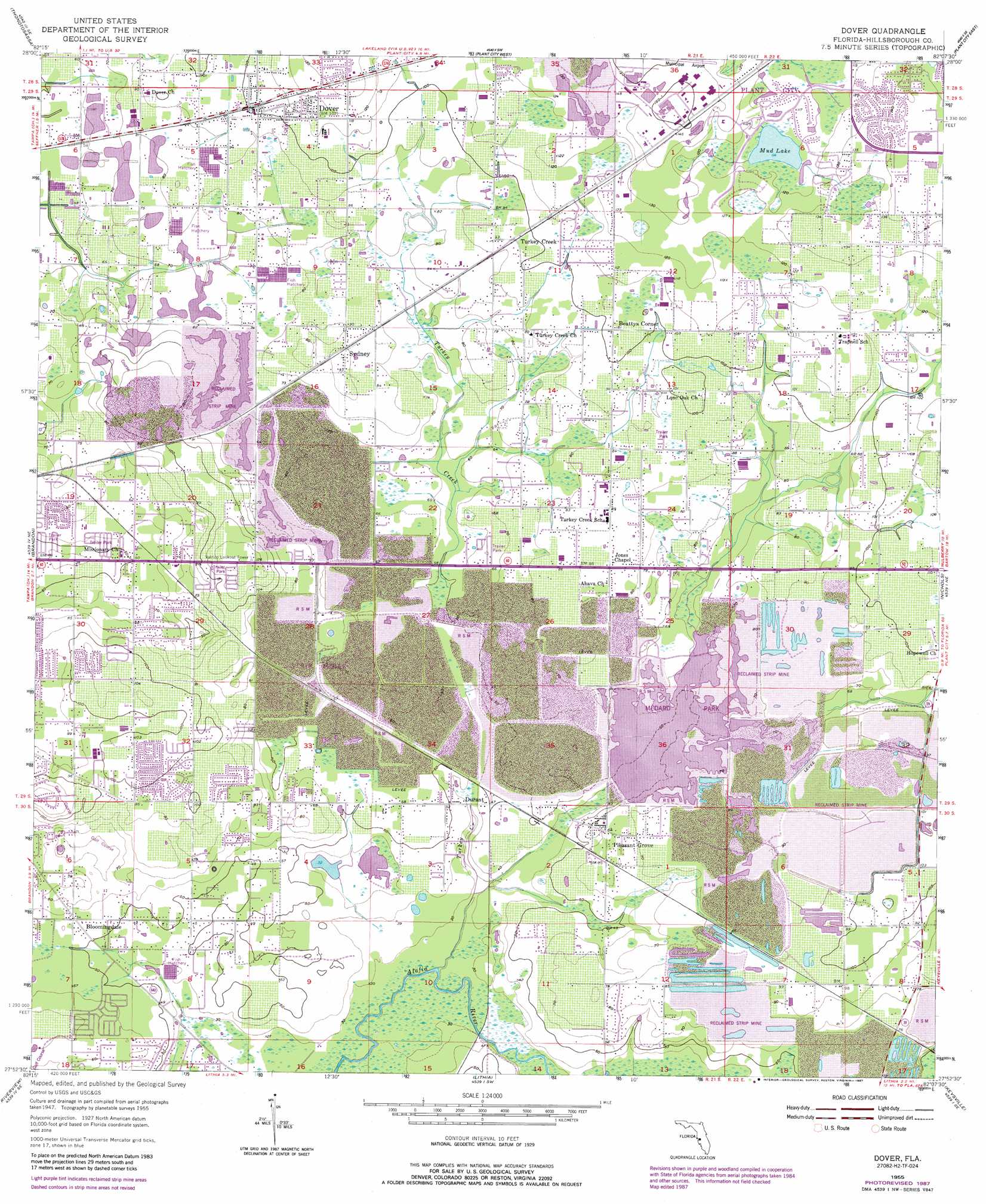
Dover Topo Map Florida
To zoom in, hover over the map of Dover
USGS Topo Quad 27082h2 - 1:24,000 scale
| Topo Map Name: | Dover |
| USGS Topo Quad ID: | 27082h2 |
| Print Size: | ca. 21 1/4" wide x 27" high |
| Southeast Coordinates: | 27.875° N latitude / 82.125° W longitude |
| Map Center Coordinates: | 27.9375° N latitude / 82.1875° W longitude |
| U.S. State: | FL |
| Filename: | O27082H2.jpg |
| Download Map JPG Image: | Dover topo map 1:24,000 scale |
| Map Type: | Topographic |
| Topo Series: | 7.5´ |
| Map Scale: | 1:24,000 |
| Source of Map Images: | United States Geological Survey (USGS) |
| Alternate Map Versions: |
Dover FL 1955, updated 1956 Download PDF Buy paper map Dover FL 1955, updated 1956 Download PDF Buy paper map Dover FL 1955, updated 1972 Download PDF Buy paper map Dover FL 1955, updated 1987 Download PDF Buy paper map Dover FL 1955, updated 1987 Download PDF Buy paper map Dover FL 2012 Download PDF Buy paper map Dover FL 2015 Download PDF Buy paper map |
1:24,000 Topo Quads surrounding Dover
Lutz |
Wesley Chapel |
Zephyrhills |
Socrum |
Providence |
Sulphur Springs |
Thonotosassa |
Plant City West |
Plant City East |
Lakeland |
Tampa |
Brandon |
Dover |
Nichols |
Mulberry |
Gibsonton |
Riverview |
Lithia |
Keysville |
Bradley Junction |
Ruskin |
Wimauma |
Fort Lonesome |
Duette Ne |
Baird |
> Back to 27082e1 at 1:100,000 scale
> Back to 27082a1 at 1:250,000 scale
> Back to U.S. Topo Maps home
Dover topo map: Gazetteer
Dover: Airports
Lewis Airport elevation 10m 32′Dover: Lakes
Mud Lake elevation 35m 114′Dover: Populated Places
Aarons Place elevation 30m 98′Abbey Grove elevation 34m 111′
Alice Winter Gardens elevation 31m 101′
Allens Cove elevation 12m 39′
Angel Run elevation 22m 72′
Arista elevation 18m 59′
Ashbrook elevation 28m 91′
Ashley Estates elevation 25m 82′
Austin Oaks elevation 21m 68′
Barron Oaks elevation 30m 98′
Beattys Corner elevation 31m 101′
Bent Tree elevation 29m 95′
Bent Tree Estates elevation 30m 98′
Bingham elevation 36m 118′
Bloomingdale elevation 16m 52′
Bonterra elevation 16m 52′
Brandon East elevation 29m 95′
Brandon Ridgeland elevation 33m 108′
Brandon Valrico Hills Estates elevation 24m 78′
Brock Acres elevation 19m 62′
Brookdale Farms elevation 25m 82′
Brown Estates elevation 27m 88′
Buckhorn elevation 18m 59′
Buckhorn Golf Club Estates elevation 33m 108′
Buckhorn Groves elevation 26m 85′
Buckhorn Hills elevation 27m 88′
Buckhorn Oaks elevation 33m 108′
Buckhorn Preserve elevation 25m 82′
Buckhorn Run elevation 21m 68′
Buckhorn Springs Mobile Villa elevation 28m 91′
Buckhorn Trace elevation 28m 91′
Buckingham elevation 30m 98′
Budd Farms elevation 32m 104′
C T Lewis Acres elevation 29m 95′
Camden Oaks elevation 18m 59′
Canter elevation 29m 95′
Canterbury Oaks elevation 12m 39′
Carriage Park elevation 31m 101′
Chancey elevation 22m 72′
Charles Donnel Acres elevation 28m 91′
Chelsea Woods elevation 22m 72′
Cimmaron elevation 30m 98′
Cinnamon Trace elevation 18m 59′
Citrus Oaks elevation 18m 59′
Citrus Wood elevation 24m 78′
Colony South elevation 25m 82′
Connell Groves elevation 24m 78′
Copper Ridge elevation 24m 78′
Country Breeze Estates elevation 24m 78′
Country Brook Estates elevation 23m 75′
Country Gate elevation 15m 49′
Country Woods Estates elevation 21m 68′
Creekside Acres elevation 24m 78′
Critter Lane elevation 35m 114′
Daniels Acres elevation 18m 59′
Davis Acres elevation 33m 108′
Delarua elevation 14m 45′
Delgado elevation 27m 88′
Diamond Hill elevation 26m 85′
Doris Coats Acres elevation 28m 91′
Doris Swilley Acres elevation 30m 98′
Dover elevation 31m 101′
Dover Oaks elevation 21m 68′
Dover Park elevation 30m 98′
Dover Woods elevation 15m 49′
Dovercrest elevation 33m 108′
Dovewood Estates elevation 27m 88′
Drakes Place elevation 19m 62′
Dumont elevation 31m 101′
Duncan Groves elevation 33m 108′
Dunham Mobile Home Park elevation 22m 72′
Dunn elevation 17m 55′
Durant elevation 13m 42′
Durant Oaks elevation 21m 68′
Durant Trails elevation 15m 49′
Durant Woods elevation 26m 85′
Eaglewood Estates elevation 18m 59′
East Brandon Estates elevation 23m 75′
East Brandon Heights elevation 26m 85′
Eastgate Extension elevation 43m 141′
Eastmonte elevation 19m 62′
Eastwood Glenn elevation 29m 95′
El Pavo Vista elevation 27m 88′
Evers Acres elevation 29m 95′
Fairlea Estates elevation 16m 52′
Fairway One elevation 12m 39′
Fairway Ridge elevation 33m 108′
Fleites Acres elevation 31m 101′
Gallagher Lakes elevation 21m 68′
Gallagher Meadows elevation 22m 72′
Gillespies Glen elevation 29m 95′
Graves Orchard elevation 29m 95′
Greenhills elevation 17m 55′
Gwaltney Acres elevation 26m 85′
Harder Oaks elevation 25m 82′
Heritage Crest elevation 22m 72′
Hidden Forest East elevation 15m 49′
High Country Acres elevation 24m 78′
Highland Country Estates elevation 31m 101′
Hinson Acres elevation 13m 42′
Holloway Creek elevation 29m 95′
Holloway Estates elevation 28m 91′
Holloway Plantation elevation 34m 111′
Hopewell Gardens elevation 43m 141′
Indian Trails elevation 30m 98′
Innergary Point elevation 28m 91′
Interdonato Place elevation 34m 111′
Irvine Heights elevation 22m 72′
Isabel Estates elevation 35m 114′
Jaudon Ranch Estates elevation 21m 68′
Jerrys elevation 16m 52′
Joannas Reserve elevation 29m 95′
Kaylas Cove elevation 30m 98′
Kings Mill elevation 30m 98′
Lees Ranch elevation 28m 91′
Legends Pass elevation 27m 88′
Lehman Acres elevation 26m 85′
Leighton Acres elevation 25m 82′
Leland Estates elevation 29m 95′
Leonard elevation 17m 55′
Lithia Ridge elevation 9m 29′
Little Alafia Creek Estates elevation 34m 111′
Lone Oak Grove elevation 28m 91′
Lone Oak Haven elevation 29m 95′
Lovitis Park elevation 37m 121′
Lucas Manor elevation 22m 72′
Lumsden Trace elevation 32m 104′
Margaline Gardens elevation 39m 127′
Marlyn Manor elevation 21m 68′
Martin elevation 18m 59′
Marvina elevation 7m 22′
Marvinia Hills elevation 12m 39′
Mason Oaks elevation 17m 55′
McDonald-Slone Estates elevation 30m 98′
McGrath elevation 27m 88′
McGraths Orangettes elevation 27m 88′
McIntosh Lakes elevation 18m 59′
Meadowood Estates elevation 31m 101′
Medley Manor elevation 26m 85′
Melouga Preserve elevation 25m 82′
Memory Lane elevation 18m 59′
Messick Acres elevation 31m 101′
Miller Woods elevation 19m 62′
Mulrennan Estates elevation 31m 101′
Mulrennan Groves North elevation 26m 85′
Oak Hill Estates elevation 31m 101′
Oaklane Estates elevation 20m 65′
Oakwood Estates elevation 42m 137′
Oakwood Forest elevation 24m 78′
Olympus Acres elevation 15m 49′
Orchid Grove elevation 24m 78′
Par Meadows elevation 35m 114′
Paradise Acres elevation 29m 95′
Park Meadow elevation 33m 108′
Parkwood Manor elevation 29m 95′
Parrish elevation 31m 101′
Pearson Estates elevation 23m 75′
Peeples Acres elevation 22m 72′
Pine Dale Estates elevation 42m 137′
Pine Grove Terrace elevation 36m 118′
Pineapple Hill elevation 30m 98′
Pleasant Grove elevation 19m 62′
Pleasant Grove Acres elevation 23m 75′
Popago Estates elevation 23m 75′
Porter Acres elevation 33m 108′
Puntkins Patch elevation 29m 95′
Puntkins Place elevation 30m 98′
Ranch Road Groves elevation 15m 49′
Raulerson Estates North elevation 22m 72′
Raulerson Estates South elevation 21m 68′
Redd elevation 22m 72′
Register Place elevation 34m 111′
Reynoso elevation 29m 95′
River Ridge Reserve elevation 16m 52′
Rosswell Acres elevation 24m 78′
Ruffin Acres elevation 18m 59′
Saint Cloud Landings elevation 30m 98′
Saint Cloud Manor elevation 30m 98′
Saint Cloud Oaks elevation 21m 68′
Saint Cloud Reserve elevation 31m 101′
Salem Church Estates elevation 27m 88′
Salem Oaks elevation 22m 72′
Sara Anna Estates elevation 19m 62′
Sexton Acres elevation 21m 68′
Shady Stables elevation 21m 68′
Shepherd Plantation elevation 27m 88′
Shupard Estates elevation 34m 111′
Sidney Highlands elevation 24m 78′
Sierra Estates elevation 21m 68′
Siloam Springs Wood elevation 18m 59′
Simmons Estate elevation 26m 85′
Somerset elevation 32m 104′
Sosa Estates elevation 12m 39′
Springdell Estates elevation 22m 72′
Stone Hedge elevation 29m 95′
Stone Hollow elevation 17m 55′
Sugar Cane Acres elevation 22m 72′
Sugarloaf Ridge elevation 24m 78′
Suncrest Estates elevation 27m 88′
Sunny Hill elevation 40m 131′
Sydney elevation 27m 88′
Sydney Crossings elevation 35m 114′
Sytsma Estates elevation 34m 111′
Taft elevation 29m 95′
Tague Acres elevation 18m 59′
Tevalo Hills elevation 19m 62′
The Cove elevation 20m 65′
The Dryden Estates elevation 22m 72′
The Paddocks elevation 37m 121′
Thompson Oaks elevation 16m 52′
Toole Place elevation 16m 52′
Tract 80 Estates elevation 20m 65′
Trails at Durant elevation 22m 72′
Trapnell Ridge elevation 30m 98′
Turkey Creek elevation 28m 91′
Turkey Creek Acres elevation 33m 108′
Turkey Hollow elevation 21m 68′
Twin Oaks elevation 43m 141′
Valrico elevation 15m 49′
Valrico Forest elevation 17m 55′
Valrico Groves elevation 33m 108′
Valrico Heights elevation 20m 65′
Valrico Highlands elevation 22m 72′
Walden Groves elevation 21m 68′
Walden Lake elevation 31m 101′
Walden Lake Fairway Estates elevation 35m 114′
Walden Lake Fairway Villas elevation 35m 114′
Wallace Road Acres elevation 26m 85′
Waller Acres elevation 30m 98′
Welch Creek Acres elevation 31m 101′
Wellington elevation 28m 91′
West Plant City elevation 43m 141′
West Plant City Farms elevation 23m 75′
Westminster elevation 30m 98′
Wetherington Oaks elevation 22m 72′
Wheeler Oak elevation 18m 59′
Whisper Lake elevation 25m 82′
Whitlock elevation 15m 49′
Windcrest Commons elevation 31m 101′
Winter Estates elevation 25m 82′
Woodfield Village elevation 41m 134′
Yates Estates elevation 13m 42′
Dover: Post Offices
Dover Post Office elevation 30m 98′Valrico Post Office elevation 12m 39′
Dover: Streams
Turkey Creek elevation 5m 16′Dover: Swamps
Williams Swamp elevation 20m 65′Dover digital topo map on disk
Buy this Dover topo map showing relief, roads, GPS coordinates and other geographical features, as a high-resolution digital map file on DVD: