Gandy Bridge Topo Map Florida
To zoom in, hover over the map of Gandy Bridge
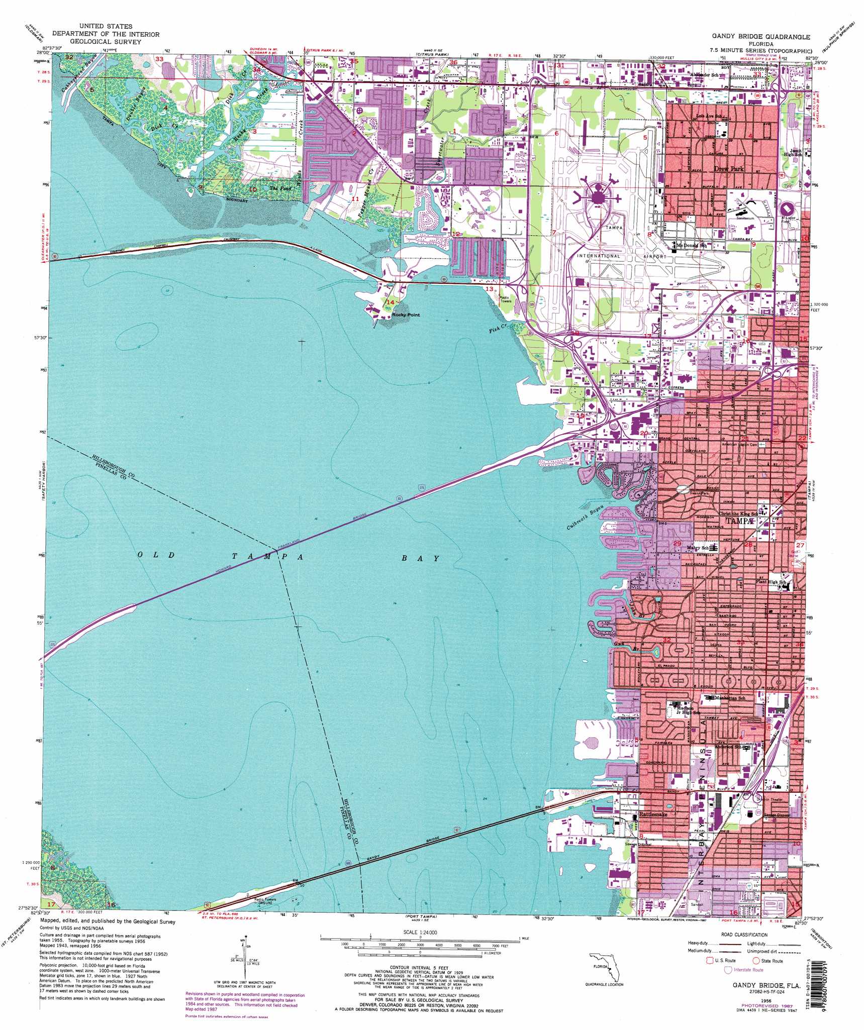
USGS Topo Quad 27082h5 - 1:24,000 scale
| Topo Map Name: | Gandy Bridge |
| USGS Topo Quad ID: | 27082h5 |
| Print Size: | ca. 21 1/4" wide x 27" high |
| Southeast Coordinates: | 27.875° N latitude / 82.5° W longitude |
| Map Center Coordinates: | 27.9375° N latitude / 82.5625° W longitude |
| U.S. State: | FL |
| Filename: | O27082H5.jpg |
| Download Map JPG Image: | Gandy Bridge topo map 1:24,000 scale |
| Map Type: | Topographic |
| Topo Series: | 7.5´ |
| Map Scale: | 1:24,000 |
| Source of Map Images: | United States Geological Survey (USGS) |
| Alternate Map Versions: |
Gandy Bridge FL 1947 Download PDF Buy paper map Gandy Bridge FL 1956, updated 1957 Download PDF Buy paper map Gandy Bridge FL 1956, updated 1965 Download PDF Buy paper map Gandy Bridge FL 1956, updated 1970 Download PDF Buy paper map Gandy Bridge FL 1956, updated 1982 Download PDF Buy paper map Gandy Bridge FL 1956, updated 1987 Download PDF Buy paper map Gandy Bridge FL 1956, updated 1987 Download PDF Buy paper map Gandy Bridge FL 1998, updated 2002 Download PDF Buy paper map Gandy Bridge FL 2012 Download PDF Buy paper map Gandy Bridge FL 2015 Download PDF Buy paper map |
1:24,000 Topo Quads surrounding Gandy Bridge
Tarpon Springs |
Elfers |
Odessa |
Lutz |
Wesley Chapel |
Dunedin |
Oldsmar |
Citrus Park |
Sulphur Springs |
Thonotosassa |
Clearwater |
Safety Harbor |
Gandy Bridge |
Tampa |
Brandon |
Seminole |
Saint Petersburg |
Port Tampa |
Gibsonton |
Riverview |
Pass-A-Grille Beach |
Cockroach Bay |
Ruskin |
Wimauma |
> Back to 27082e1 at 1:100,000 scale
> Back to 27082a1 at 1:250,000 scale
> Back to U.S. Topo Maps home
Gandy Bridge topo map: Gazetteer
Gandy Bridge: Airports
Helicopter Leasing and Services Incorporated Heliport elevation 8m 26′L M Hughey Heliport elevation 0m 0′
Tampa International Airport elevation 5m 16′
Gandy Bridge: Bays
Culbreath Bayou elevation 0m 0′Old Tampa Bay elevation 0m 0′
Gandy Bridge: Bridges
Gandy Bridge elevation 0m 0′Howard Franklin Bridge elevation 0m 0′
Gandy Bridge: Capes
Rocky Point elevation 0m 0′Gandy Bridge: Crossings
Interchange 39A elevation 1m 3′Interchange 39B elevation 2m 6′
Interchange 40A elevation 2m 6′
Interchange 40B elevation 3m 9′
Interchange 41A elevation 6m 19′
Interchange 41B elevation 9m 29′
Gandy Bridge: Guts
Cabbagehead Bayou elevation 0m 0′Double Bayou elevation 0m 0′
Pepper Mound Creek elevation 1m 3′
Gandy Bridge: Lakes
The Pond elevation 0m 0′Gandy Bridge: Parks
Al Lopez Field elevation 11m 36′Al Lopez Park elevation 8m 26′
Al Palonis Park elevation 1m 3′
Ben T Davis Beach elevation 0m 0′
Bobby Hicks Park elevation 2m 6′
Cal Dickson Tennis Center elevation 5m 16′
Charles B Williams Park elevation 4m 13′
Corona Park elevation 5m 16′
Cypress Point Park elevation 0m 0′
Foster Park elevation 2m 6′
Gandy Park elevation 1m 3′
Houlihan Stadium elevation 10m 32′
Raymond James Stadium elevation 10m 32′
Roland Park elevation 5m 16′
Skyland Park elevation 6m 19′
Swann Park elevation 1m 3′
Gandy Bridge: Populated Places
Ad Mer elevation 3m 9′Al Mar elevation 3m 9′
Alfredo Trujillo elevation 1m 3′
Alta Vista Tracts elevation 3m 9′
Anadell elevation 4m 13′
Andrea elevation 5m 16′
Anita elevation 2m 6′
Arlene Manor elevation 3m 9′
Audubon Park elevation 1m 3′
Azalea Terrace elevation 2m 6′
Azeele Heights elevation 2m 6′
Azeele Park elevation 5m 16′
Ball elevation 2m 6′
Barbara Lane elevation 1m 3′
Barnelia elevation 5m 16′
Bay Breeze elevation 3m 9′
Bay Crest Park elevation 1m 3′
Bay Port Colony elevation 0m 0′
Bayport Village elevation 0m 0′
Bayshore Estates elevation 2m 6′
Bayside East elevation 1m 3′
Bayside Key elevation 1m 3′
Bayside South elevation 1m 3′
Bayside Village elevation 0m 0′
Bayside West elevation 0m 0′
Beach Park elevation 2m 6′
Beach Park Isle elevation 0m 0′
Beach Park Place elevation 3m 9′
Beach Way elevation 4m 13′
Beans elevation 2m 6′
Bel Grand elevation 3m 9′
Bel Mar Shores elevation 1m 3′
Bell Park elevation 5m 16′
Belvedere Acres elevation 8m 26′
Belvedere Park elevation 6m 19′
Benjamins Farms elevation 4m 13′
Beverly Park elevation 4m 13′
Blackburn elevation 2m 6′
Bon Air elevation 6m 19′
Bon Air West elevation 7m 22′
Bonnie Brae elevation 5m 16′
Boyles elevation 5m 16′
Bridgeview Estates elevation 0m 0′
Canal Shores elevation 1m 3′
Carol Shores elevation 0m 0′
Chandler elevation 4m 13′
Chateau Villa elevation 3m 9′
Clarice Place elevation 3m 9′
Cloverdale elevation 1m 3′
Cole elevation 3m 9′
Cornerstone Plaza elevation 6m 19′
Crowder elevation 4m 13′
Culbreath Bayou elevation 2m 6′
Culbreath Isles elevation 0m 0′
Cypress Estates elevation 5m 16′
Dana Shores elevation 0m 0′
Deuber Place elevation 6m 19′
Drew Park elevation 9m 29′
East View elevation 2m 6′
El Prado Gardens elevation 4m 13′
Eleanor Villas elevation 3m 9′
Elenor Place elevation 5m 16′
Emerson elevation 1m 3′
Entrada elevation 3m 9′
Fair Oaks Manor elevation 5m 16′
Fairlawn Estates elevation 3m 9′
Forest Heights elevation 6m 19′
Forest Park elevation 4m 13′
Gandy Boulevard Park elevation 3m 9′
Gandy Gardens elevation 3m 9′
Gandy Manor elevation 3m 9′
Gandy Manor Estates elevation 3m 9′
Gardenia elevation 5m 16′
Golden Estates elevation 3m 9′
Golf View Estates elevation 6m 19′
Golfwood Estates elevation 3m 9′
Gray Terrace elevation 1m 3′
Griflow Park elevation 4m 13′
Guernsey Estates elevation 2m 6′
Hanan Estates elevation 4m 13′
Hanan Park elevation 2m 6′
Harbor Shores elevation 0m 0′
Henderson Beach elevation 2m 6′
Henderson Place elevation 6m 19′
Hesperides elevation 2m 6′
Hesperides Manor elevation 1m 3′
Highland Terrace elevation 5m 16′
Hilton elevation 4m 13′
Holiday Village elevation 2m 6′
Holly Park elevation 1m 3′
Horizon Place elevation 10m 32′
Ida Heights elevation 5m 16′
Interbay elevation 4m 13′
Jean Place elevation 6m 19′
Keats elevation 2m 6′
Kelloggs elevation 5m 16′
Keystone Homes elevation 1m 3′
Kingston Court Villas elevation 6m 19′
Krentel Park elevation 3m 9′
Leila Avenue Villas elevation 3m 9′
Lincoln Gardens elevation 9m 29′
Live Oak Place elevation 6m 19′
Louis Place elevation 6m 19′
Lynwood elevation 4m 13′
MacKenzie elevation 3m 9′
Madigan Park elevation 3m 9′
Manhattan elevation 3m 9′
Manhattan Manor elevation 2m 6′
Manhattan Terrace elevation 2m 6′
Marene Place elevation 1m 3′
Mariner Estates elevation 0m 0′
Maryland Manor elevation 3m 9′
Masons elevation 6m 19′
Midwest elevation 4m 13′
Milgwen elevation 4m 13′
Minneola elevation 5m 16′
Morningside elevation 6m 19′
Morrison Court elevation 5m 16′
Norma Park elevation 2m 6′
Normandee Heights elevation 5m 16′
North Bon Air elevation 6m 19′
Occident elevation 1m 3′
Omar elevation 1m 3′
Overlook elevation 4m 13′
Ownby elevation 2m 6′
Palermo elevation 7m 22′
Palm Park elevation 3m 9′
Palm Way elevation 3m 9′
Palmere elevation 6m 19′
Paradise elevation 2m 6′
Park West elevation 10m 32′
Parkdale elevation 10m 32′
Pelican Island elevation 0m 0′
Penner elevation 1m 3′
Pershing Park elevation 6m 19′
Picadilly elevation 4m 13′
Pine Grove elevation 5m 16′
Rainbow Court elevation 1m 3′
Raines elevation 5m 16′
Rattlesnake elevation 1m 3′
Regency Cove elevation 1m 3′
Rico Diaz elevation 3m 9′
Roberts elevation 5m 16′
Rocky Creek Estates elevation 0m 0′
Rocky Point Village elevation 3m 9′
Ronnie Place elevation 4m 13′
Rosedale elevation 4m 13′
Rosedale North elevation 5m 16′
Saint Clear Place elevation 3m 9′
San Marino Bay Estates elevation 0m 0′
San Orludo elevation 4m 13′
San Rafael Place elevation 4m 13′
Sanctuary at Sweetwater Creek elevation 2m 6′
School View Estates elevation 4m 13′
Seldomridge elevation 5m 16′
Sheridan elevation 1m 3′
Silvan elevation 2m 6′
Sonia elevation 5m 16′
Southland elevation 5m 16′
Spencer Place elevation 5m 16′
Stephanie Way elevation 2m 6′
Sterling elevation 5m 16′
Stewart elevation 1m 3′
Stonehouse elevation 6m 19′
Stoney Point elevation 0m 0′
Sunset Beach elevation 0m 0′
Sunset Camp elevation 1m 3′
Sunset Park elevation 0m 0′
Sunset Park Isles elevation 1m 3′
Sunset Terrace elevation 1m 3′
Sweetwater elevation 0m 0′
Sweetwater Creek elevation 2m 6′
Sweetwater Estates elevation 1m 3′
Sweetwater Farms elevation 1m 3′
Sweetwater Terrace elevation 1m 3′
Tampa Villas South elevation 3m 9′
Tampania elevation 2m 6′
Temple Square elevation 3m 9′
The Borghese Villas at Westshore elevation 4m 13′
The Reserve of Old Tampa Bay elevation 0m 0′
Treasure Park elevation 3m 9′
Triangle Heights elevation 6m 19′
Van Diver Place elevation 5m 16′
Venetian Shores elevation 2m 6′
Villa Sonoma at International Plaza elevation 6m 19′
Virginia Estates elevation 3m 9′
Virginia Park elevation 5m 16′
Virginia Terrace elevation 4m 13′
Waterford on the Bay elevation 1m 3′
Waterfront Estates elevation 1m 3′
Watts elevation 6m 19′
Weiland elevation 4m 13′
West Shore Crest elevation 1m 3′
West Shore Estates elevation 4m 13′
West Shore Manor elevation 1m 3′
West Shore Place elevation 2m 6′
West View elevation 1m 3′
West Virginia Place elevation 5m 16′
Westlake elevation 3m 9′
Westshore Estates South elevation 2m 6′
Westwego elevation 4m 13′
White Estates elevation 3m 9′
Wood Grove elevation 5m 16′
Woodward elevation 4m 13′
Gandy Bridge: Post Offices
Interbay Post Office elevation 2m 6′Peninsula Tampa Post Office elevation 5m 16′
Town N Country Post Office elevation 2m 6′
Gandy Bridge: Streams
Dick Creek elevation 0m 0′Fish Creek elevation 0m 0′
Gun Branch elevation 0m 0′
John Branch elevation 0m 0′
Rocky Creek elevation 0m 0′
Sweetwater Creek elevation 0m 0′
Woods Creek elevation 0m 0′
Gandy Bridge digital topo map on disk
Buy this Gandy Bridge topo map showing relief, roads, GPS coordinates and other geographical features, as a high-resolution digital map file on DVD: