Clearwater Topo Map Florida
To zoom in, hover over the map of Clearwater
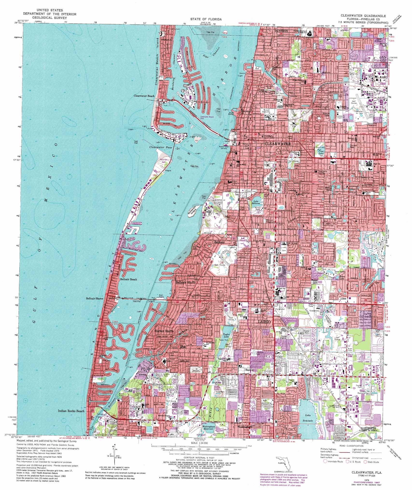
USGS Topo Quad 27082h7 - 1:24,000 scale
| Topo Map Name: | Clearwater |
| USGS Topo Quad ID: | 27082h7 |
| Print Size: | ca. 21 1/4" wide x 27" high |
| Southeast Coordinates: | 27.875° N latitude / 82.75° W longitude |
| Map Center Coordinates: | 27.9375° N latitude / 82.8125° W longitude |
| U.S. State: | FL |
| Filename: | O27082H7.jpg |
| Download Map JPG Image: | Clearwater topo map 1:24,000 scale |
| Map Type: | Topographic |
| Topo Series: | 7.5´ |
| Map Scale: | 1:24,000 |
| Source of Map Images: | United States Geological Survey (USGS) |
| Alternate Map Versions: |
Clearwater FL 1943, updated 1952 Download PDF Buy paper map Clearwater FL 1943, updated 1961 Download PDF Buy paper map Clearwater FL 1943, updated 1961 Download PDF Buy paper map Clearwater FL 1974, updated 1976 Download PDF Buy paper map Clearwater FL 1974, updated 1987 Download PDF Buy paper map Clearwater FL 1995, updated 2000 Download PDF Buy paper map Clearwater FL 2012 Download PDF Buy paper map Clearwater FL 2015 Download PDF Buy paper map |
1:24,000 Topo Quads surrounding Clearwater
Tarpon Springs |
Elfers |
Odessa |
||
Dunedin |
Oldsmar |
Citrus Park |
||
Clearwater |
Safety Harbor |
Gandy Bridge |
||
Seminole |
Saint Petersburg |
Port Tampa |
||
Pass-A-Grille Beach |
Cockroach Bay |
> Back to 27082e1 at 1:100,000 scale
> Back to 27082a1 at 1:250,000 scale
> Back to U.S. Topo Maps home
Clearwater topo map: Gazetteer
Clearwater: Airports
Clearwater Air Park elevation 21m 68′Morton Plant Hospital Heliport elevation 8m 26′
Pinellas County Sherriffs Building Heliport elevation 9m 29′
Clearwater: Bays
Clearwater Bay elevation 0m 0′Clearwater Harbor elevation 0m 0′
Clearwater: Capes
Church Creek Point elevation 2m 6′Clearwater Point elevation 1m 3′
Howard Point elevation 0m 0′
McKay Point elevation 0m 0′
Point Pleasant elevation 0m 0′
Prickly Pear Point elevation 0m 0′
Shell Point elevation 0m 0′
Clearwater: Channels
Clearwater Pass elevation 0m 0′Mandalay Channel elevation 0m 0′
Pope Channel elevation 0m 0′
Clearwater: Islands
Belleview Island elevation 3m 9′Big Mangrove Key elevation 0m 0′
Broken Island elevation 0m 0′
Clearwater Beach Island elevation 1m 3′
Cow Island (historical) elevation 0m 0′
Grassy Island (historical) elevation 0m 0′
Lone Palm Island (historical) elevation 0m 0′
Pasadees Key elevation 0m 0′
Pope Island (historical) elevation 0m 0′
Sand Key elevation 1m 3′
Clearwater: Lakes
Crest Lake elevation 20m 65′Excelsior elevation 21m 68′
Hobart Lake elevation 19m 62′
Keene Lake elevation 5m 16′
Lake Bellevue elevation 11m 36′
Lake Citrus elevation 18m 59′
Lake Lucille elevation 15m 49′
Sunny Lake elevation 9m 29′
Clearwater: Parks
12th Avenue Park elevation 2m 6′12th Street Beach Access Park elevation 2m 6′
16th Street Park elevation 1m 3′
19th Beach Access and Park elevation 1m 3′
1st Street Boardwalk elevation 2m 6′
20th Street Park elevation 1m 3′
25th Street Park elevation 1m 3′
6th Street Beach Access Park elevation 2m 6′
7th Street Park elevation 0m 0′
Allen's Creek Park elevation 5m 16′
Ann Circle Park elevation 17m 55′
Atrium Park elevation 8m 26′
Bay Front Park elevation 0m 0′
Bay Park On Sand Key elevation 2m 6′
Bayfront Tennis Complex elevation 2m 6′
Bayside Park elevation 1m 3′
Belle Isle Park and Strip elevation 0m 0′
Belmont Park elevation 6m 19′
Belmont Playground elevation 19m 62′
Brown Park elevation 0m 0′
Calades Island State Park elevation -3m -10′
Cedar Groves elevation 20m 65′
Charles Park elevation 7m 22′
Charter Oaks elevation 20m 65′
Cherry Harris Park elevation 4m 13′
Chief Chic-A-Si Park elevation 1m 3′
Clearwater Beach elevation 1m 3′
Clearwater Beach Family Aquatic Center elevation 0m 0′
Clearwater Beach Park elevation 0m 0′
Clearwater Beach Recreation Complex elevation 1m 3′
Coachman Park elevation 2m 6′
Crest Lake Park elevation 22m 72′
Crossman Park elevation 2m 6′
De Soto Park elevation 13m 42′
Drew Plaza elevation 21m 68′
Edgewater Drive Park elevation 1m 3′
Fairview Park elevation 12m 39′
Fountain Square elevation 14m 45′
Frank Tack Park elevation 19m 62′
Gaienne Park elevation 9m 29′
Garden Avenue Park elevation 10m 32′
Gardenia Park elevation 15m 49′
George C McGough Nature Park elevation 1m 3′
Glen Oaks Park elevation 7m 22′
Glenwood Park elevation 15m 49′
Grass Plot elevation 12m 39′
Hallett Park elevation 9m 29′
Harborview Center elevation 2m 6′
Harding Plaza elevation 21m 68′
Hibiscus Lake elevation 6m 19′
Highland Family Aquatic Center elevation 3m 9′
Highland Recreation Complex elevation 3m 9′
Hillcrest Park elevation 13m 42′
Hunter Park elevation 15m 49′
Indian Rocks Beach Nature Preserve elevation 0m 0′
Jack Russell Stadium elevation 6m 19′
John R Bonner Park elevation 1m 3′
Keegan Clair Park elevation 2m 6′
Kolb Park elevation 0m 0′
Lake Hobart South elevation 20m 65′
Lake Lucille Park elevation 15m 49′
Lake Villa Park elevation 20m 65′
Largo Central Park elevation 13m 42′
Lawn Bowls and Shuffleboard Complex elevation 2m 6′
Leash-Free Dog Park elevation 1m 3′
Lickton Field elevation 20m 65′
Magnolia Park elevation 15m 49′
Magnolia Park elevation 15m 49′
Mandalay Park elevation 1m 3′
Marshall Park elevation 4m 13′
Martin Luther King Jr Community Center elevation 5m 16′
Marymont Park elevation 21m 68′
McKay Playfield elevation 1m 3′
Memorial Causeway elevation 2m 6′
Memorial Parks 1 and 2 elevation 1m 3′
Missouri Avenue elevation 19m 62′
Montclair Park elevation 16m 52′
Morgan Street Beach Access elevation 0m 0′
North Greenwood Recreation and Aquatic Complex elevation 6m 19′
Norton Park elevation 13m 42′
Overbrook Park elevation 4m 13′
Park Avenue elevation 13m 42′
Phillip Jones Park elevation 1m 3′
Pier 60 Park elevation 1m 3′
Pinellas Park elevation 13m 42′
Rex Beach elevation 14m 45′
Ridgecrest Park elevation 13m 42′
Ridgecrest Park elevation 13m 42′
Ross Norton Recreation Complex elevation 13m 42′
Rush Field elevation 4m 13′
Sand Key Bayside Park elevation 2m 6′
Sand Key County Park elevation 2m 6′
Sand Key Park elevation 1m 3′
Second Street Park elevation 0m 0′
Skycrest Park elevation 20m 65′
South Park elevation 0m 0′
Spring Lake Park elevation 15m 49′
State Street Park elevation 4m 13′
Station Square Park elevation 8m 26′
Sunny Park elevation 13m 42′
Sunset Sam Park at Island Estates elevation 0m 0′
Taylor Park elevation 13m 42′
Terrace Lake elevation 21m 68′
The Mall elevation 15m 49′
Thompson Park elevation 0m 0′
Ulmer Park elevation 21m 68′
Valencia Park elevation 20m 65′
Veterans Park elevation 1m 3′
Walsingham County Park elevation 14m 45′
Waterfall Park elevation 8m 26′
Wildwood Park elevation 15m 49′
Winston Park elevation 2m 6′
Woodrow Avenue Park elevation 20m 65′
Wright Park elevation 13m 42′
Clearwater: Populated Places
Anona elevation 5m 16′Baskin elevation 20m 65′
Belleair elevation 14m 45′
Belleair Beach elevation 1m 3′
Belleair Bluffs elevation 14m 45′
Belleair Shores elevation 3m 9′
Clearwater elevation 9m 29′
Clearwater Beach elevation 1m 3′
Habor Bluffs elevation 12m 39′
Harbor Bluffs elevation 3m 9′
Indian Rocks Beach elevation 0m 0′
Largo elevation 10m 32′
Ridgecrest elevation 17m 55′
Ulmerton elevation 5m 16′
Walsingham elevation 17m 55′
Clearwater: Post Offices
Belleair Post Office (historical) elevation 14m 45′Largo Post Office elevation 13m 42′
Sunset Point Post Office elevation 15m 49′
Clearwater: Reservoirs
Taylor Lake elevation 11m 36′Walsingham Reservoir elevation 14m 45′
Clearwater: Streams
Church Creek elevation 0m 0′Long Bayou elevation 2m 6′
McKay Creek elevation 0m 0′
Stevenson Creek elevation 0m 0′
Clearwater: Trails
The Pinellas Trail elevation 8m 26′Clearwater digital topo map on disk
Buy this Clearwater topo map showing relief, roads, GPS coordinates and other geographical features, as a high-resolution digital map file on DVD: