La Parra Ranch Ne Topo Map Texas
To zoom in, hover over the map of La Parra Ranch Ne
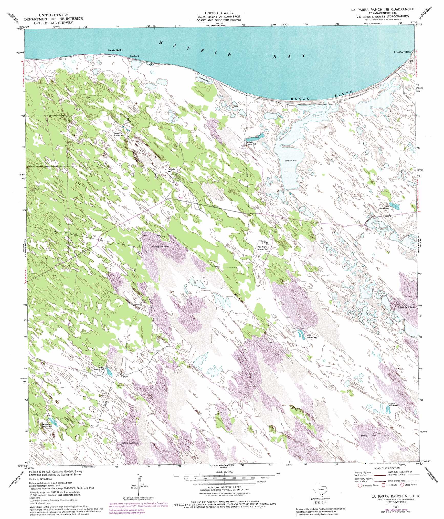
USGS Topo Quad 27097b5 - 1:24,000 scale
| Topo Map Name: | La Parra Ranch Ne |
| USGS Topo Quad ID: | 27097b5 |
| Print Size: | ca. 21 1/4" wide x 27" high |
| Southeast Coordinates: | 27.125° N latitude / 97.5° W longitude |
| Map Center Coordinates: | 27.1875° N latitude / 97.5625° W longitude |
| U.S. State: | TX |
| Filename: | o27097b5.jpg |
| Download Map JPG Image: | La Parra Ranch Ne topo map 1:24,000 scale |
| Map Type: | Topographic |
| Topo Series: | 7.5´ |
| Map Scale: | 1:24,000 |
| Source of Map Images: | United States Geological Survey (USGS) |
| Alternate Map Versions: |
Sarita 4 NE TX 1951, updated 1953 Download PDF Buy paper map Sarita 4 NE TX 1951, updated 1978 Download PDF Buy paper map La Parra Ranch NE TX 1951, updated 1983 Download PDF Buy paper map La Parra Ranch NE TX 2010 Download PDF Buy paper map La Parra Ranch NE TX 2013 Download PDF Buy paper map La Parra Ranch NE TX 2016 Download PDF Buy paper map |
1:24,000 Topo Quads surrounding La Parra Ranch Ne
Ricardo |
Riviera Beach Nw |
Riviera Beach Ne |
South Bird Island Nw |
South Bird Island |
Riviera |
Riviera Beach |
Kleberg Point |
Point Of Rocks |
South Bird Island Se |
Sarita |
La Parra Ranch |
La Parra Ranch Ne |
Yarborough Pass |
|
Turcotte |
La Parra Ranch Sw |
La Parra Ranch Se |
Potrero Cortado |
|
Armstrong |
San Pedro Ranch |
Maria Estella Well |
Potrero Lopeno Nw |
> Back to 27097a1 at 1:100,000 scale
> Back to 27096a1 at 1:250,000 scale
> Back to U.S. Topo Maps home
La Parra Ranch Ne topo map: Gazetteer
La Parra Ranch Ne: Areas
Los Corrallos elevation 1m 3′La Parra Ranch Ne: Capes
Pie de Gallo elevation 1m 3′La Parra Ranch Ne: Cliffs
Black Bluff elevation 3m 9′La Parra Ranch Ne: Wells
Caso Artesian Well elevation 3m 9′Diablo Artesian Well elevation 4m 13′
Huero Artesian Well elevation 4m 13′
Mota Negra Artesian Well elevation 3m 9′
Pamoranas Artesian Well elevation 5m 16′
Parrita Well elevation 4m 13′
Pasadizo Artesian Well elevation 2m 6′
Santiago Artesian Well elevation 2m 6′
Tio Chon Well elevation 2m 6′
La Parra Ranch Ne digital topo map on disk
Buy this La Parra Ranch Ne topo map showing relief, roads, GPS coordinates and other geographical features, as a high-resolution digital map file on DVD: