Paisano Lake Topo Map Texas
To zoom in, hover over the map of Paisano Lake
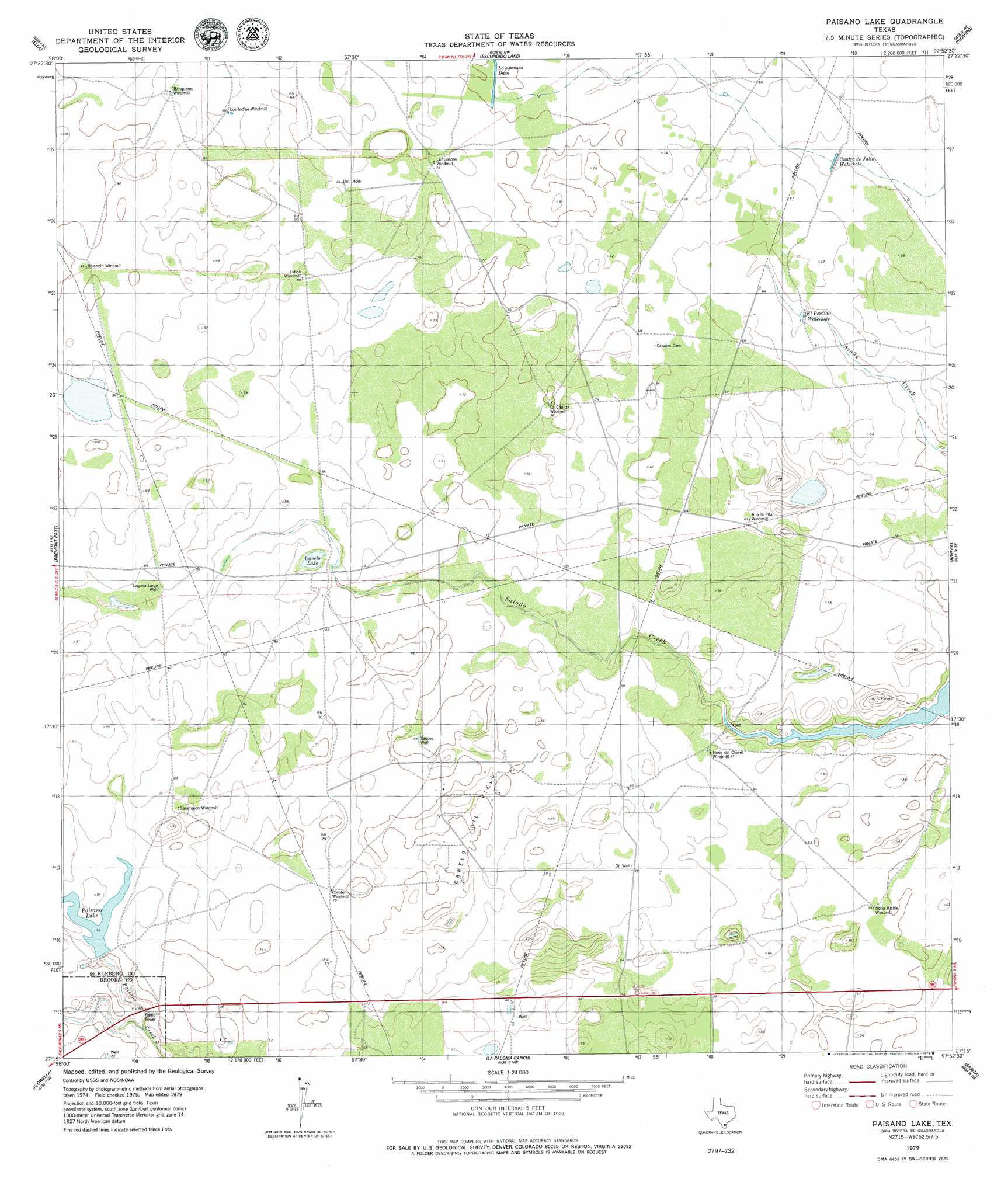
USGS Topo Quad 27097c8 - 1:24,000 scale
| Topo Map Name: | Paisano Lake |
| USGS Topo Quad ID: | 27097c8 |
| Print Size: | ca. 21 1/4" wide x 27" high |
| Southeast Coordinates: | 27.25° N latitude / 97.875° W longitude |
| Map Center Coordinates: | 27.3125° N latitude / 97.9375° W longitude |
| U.S. State: | TX |
| Filename: | o27097c8.jpg |
| Download Map JPG Image: | Paisano Lake topo map 1:24,000 scale |
| Map Type: | Topographic |
| Topo Series: | 7.5´ |
| Map Scale: | 1:24,000 |
| Source of Map Images: | United States Geological Survey (USGS) |
| Alternate Map Versions: |
Paisano Lake TX 1979, updated 1979 Download PDF Buy paper map Paisano Lake TX 2010 Download PDF Buy paper map Paisano Lake TX 2013 Download PDF Buy paper map Paisano Lake TX 2016 Download PDF Buy paper map |
1:24,000 Topo Quads surrounding Paisano Lake
Palito Blanco |
Ben Bolt Se |
Kingsville West |
Kingsville East |
Concordia |
Seeligson Ranch |
Ella |
Escondido Lake |
Ricardo |
Riviera Beach Nw |
Premont West |
Premont East |
Paisano Lake |
Riviera |
Riviera Beach |
Falfurrias |
Flowella |
La Paloma Ranch |
Sarita |
La Parra Ranch |
Cage Ranch |
Falfurrias Se |
Sarita Sw |
Turcotte |
La Parra Ranch Sw |
> Back to 27097a1 at 1:100,000 scale
> Back to 27096a1 at 1:250,000 scale
> Back to U.S. Topo Maps home
Paisano Lake topo map: Gazetteer
Paisano Lake: Dams
King Ranch Dam Number 3 elevation 23m 75′Lampasosa Dam elevation 23m 75′
Paisano Lake: Lakes
Canelo Lake elevation 24m 78′Cuatro de Julio Waterhole elevation 18m 59′
El Perdido Waterhole elevation 18m 59′
Paisano Lake: Oilfields
Canelo Oil Field elevation 23m 75′Paisano Lake: Reservoirs
Paisano Lake elevation 23m 75′Reservoir Number 2 elevation 23m 75′
Paisano Lake: Wells
Laguna Larga Well elevation 26m 85′Sauces Well elevation 23m 75′
Paisano Lake digital topo map on disk
Buy this Paisano Lake topo map showing relief, roads, GPS coordinates and other geographical features, as a high-resolution digital map file on DVD: