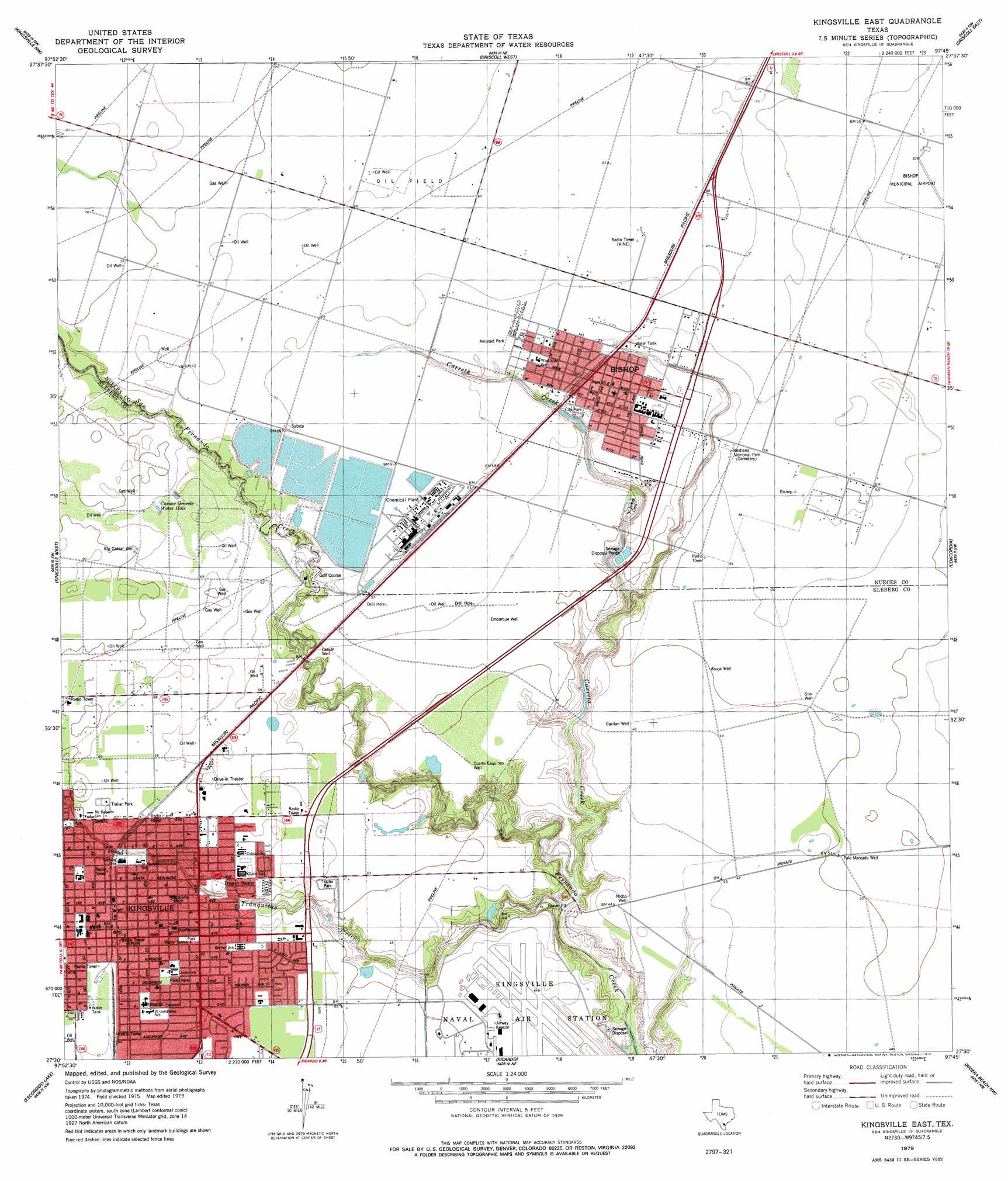
Kingsville East Topo Map Texas
To zoom in, hover over the map of Kingsville East
USGS Topo Quad 27097e7 - 1:24,000 scale
| Topo Map Name: | Kingsville East |
| USGS Topo Quad ID: | 27097e7 |
| Print Size: | ca. 21 1/4" wide x 27" high |
| Southeast Coordinates: | 27.5° N latitude / 97.75° W longitude |
| Map Center Coordinates: | 27.5625° N latitude / 97.8125° W longitude |
| U.S. State: | TX |
| Filename: | o27097e7.jpg |
| Download Map JPG Image: | Kingsville East topo map 1:24,000 scale |
| Map Type: | Topographic |
| Topo Series: | 7.5´ |
| Map Scale: | 1:24,000 |
| Source of Map Images: | United States Geological Survey (USGS) |
| Alternate Map Versions: |
Kingsville East TX 1979, updated 1979 Download PDF Buy paper map Kingsville East TX 2010 Download PDF Buy paper map Kingsville East TX 2013 Download PDF Buy paper map Kingsville East TX 2016 Download PDF Buy paper map |
1:24,000 Topo Quads surrounding Kingsville East
Alice North |
Agua Dulce |
Banquete |
Robstown |
Annaville |
Alice South |
Kingsville Nw |
Driscoll West |
Driscoll East |
Petronila Ne |
Ben Bolt Se |
Kingsville West |
Kingsville East |
Concordia |
Laureles Ranch |
Ella |
Escondido Lake |
Ricardo |
Riviera Beach Nw |
Riviera Beach Ne |
Premont East |
Paisano Lake |
Riviera |
Riviera Beach |
Kleberg Point |
> Back to 27097e1 at 1:100,000 scale
> Back to 27096a1 at 1:250,000 scale
> Back to U.S. Topo Maps home
Kingsville East topo map: Gazetteer
Kingsville East: Airports
Bishop Municipal Airport elevation 16m 52′Kingsville Naval Air Station elevation 14m 45′
Kingsville East: Oilfields
Bishop Oil Field elevation 21m 68′Kingsville East: Parks
Amistad Park elevation 19m 62′Bishop City Park elevation 17m 55′
Flato Park elevation 19m 62′
Restland Memorial Park elevation 17m 55′
Kingsville East: Populated Places
Bishop elevation 19m 62′Kingsville elevation 18m 59′
Kingsville East: Reservoirs
Caesar Grande Water Hole elevation 21m 68′Kingsville East: Streams
Carreta Creek elevation 3m 9′Tranquitas Creek elevation 3m 9′
Kingsville East: Wells
Big Caesar Well elevation 24m 78′Caesar Well elevation 16m 52′
Cuarto Esquinas Well elevation 14m 45′
Embarque Well elevation 16m 52′
Gavilan Well elevation 14m 45′
Nicho Well elevation 12m 39′
Palo Marcado Well elevation 16m 52′
Kingsville East digital topo map on disk
Buy this Kingsville East topo map showing relief, roads, GPS coordinates and other geographical features, as a high-resolution digital map file on DVD: