Kingsville West Topo Map Texas
To zoom in, hover over the map of Kingsville West
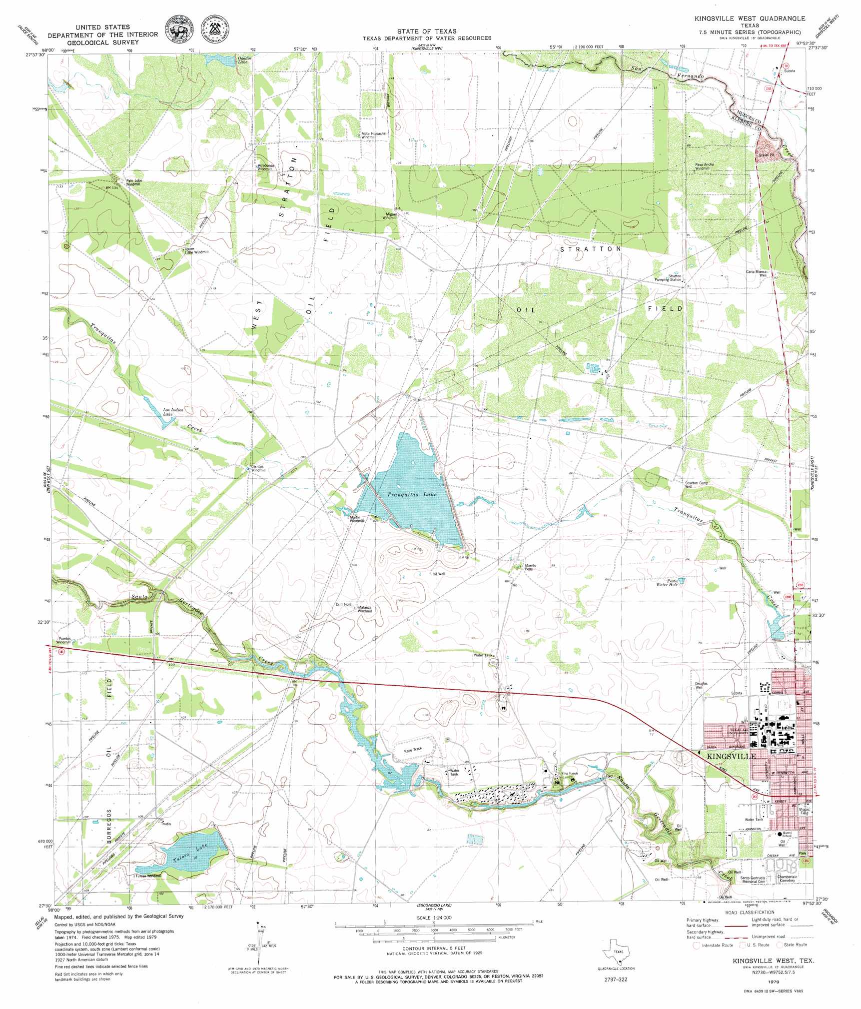
USGS Topo Quad 27097e8 - 1:24,000 scale
| Topo Map Name: | Kingsville West |
| USGS Topo Quad ID: | 27097e8 |
| Print Size: | ca. 21 1/4" wide x 27" high |
| Southeast Coordinates: | 27.5° N latitude / 97.875° W longitude |
| Map Center Coordinates: | 27.5625° N latitude / 97.9375° W longitude |
| U.S. State: | TX |
| Filename: | o27097e8.jpg |
| Download Map JPG Image: | Kingsville West topo map 1:24,000 scale |
| Map Type: | Topographic |
| Topo Series: | 7.5´ |
| Map Scale: | 1:24,000 |
| Source of Map Images: | United States Geological Survey (USGS) |
| Alternate Map Versions: |
Kingsville West TX 1979, updated 1979 Download PDF Buy paper map Kingsville West TX 2010 Download PDF Buy paper map Kingsville West TX 2013 Download PDF Buy paper map Kingsville West TX 2016 Download PDF Buy paper map |
1:24,000 Topo Quads surrounding Kingsville West
San Diego |
Alice North |
Agua Dulce |
Banquete |
Robstown |
Ben Bolt Nw |
Alice South |
Kingsville Nw |
Driscoll West |
Driscoll East |
Palito Blanco |
Ben Bolt Se |
Kingsville West |
Kingsville East |
Concordia |
Seeligson Ranch |
Ella |
Escondido Lake |
Ricardo |
Riviera Beach Nw |
Premont West |
Premont East |
Paisano Lake |
Riviera |
Riviera Beach |
> Back to 27097e1 at 1:100,000 scale
> Back to 27096a1 at 1:250,000 scale
> Back to U.S. Topo Maps home
Kingsville West topo map: Gazetteer
Kingsville West: Airports
Oliver Till Airport elevation 26m 85′Kingsville West: Dams
King Ranch Dam Number 3 elevation 30m 98′King Ranch Dam Number 5 elevation 27m 88′
King Ranch Dam Number 6 elevation 29m 95′
Kingsville West: Oilfields
Stratton Oil Field elevation 28m 91′West Stratton Oil Field elevation 35m 114′
Kingsville West: Parks
Mopac Field elevation 21m 68′Kingsville West: Reservoirs
Los Indios Lake elevation 35m 114′Ogados Lake elevation 38m 124′
Posta Water Hole elevation 24m 78′
Reservoir Number 3 elevation 30m 98′
Reservoir Number 5 elevation 27m 88′
Reservoir Number 6 elevation 29m 95′
Tranquitas Lake elevation 31m 101′
Tulosa Lake elevation 30m 98′
Kingsville West: Wells
Carta Blanca Well elevation 25m 82′Douglas Well elevation 24m 78′
Stratton Camp Well elevation 26m 85′
Kingsville West digital topo map on disk
Buy this Kingsville West topo map showing relief, roads, GPS coordinates and other geographical features, as a high-resolution digital map file on DVD: