Corpus Christi Topo Map Texas
To zoom in, hover over the map of Corpus Christi
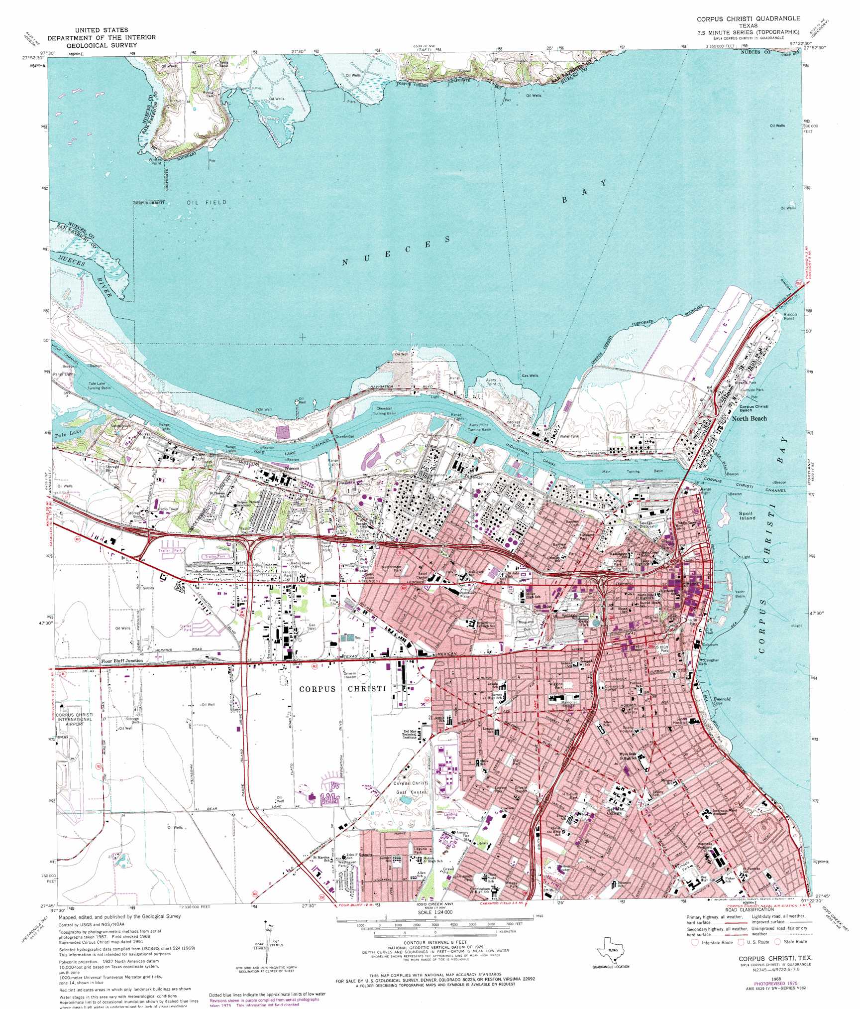
USGS Topo Quad 27097g4 - 1:24,000 scale
| Topo Map Name: | Corpus Christi |
| USGS Topo Quad ID: | 27097g4 |
| Print Size: | ca. 21 1/4" wide x 27" high |
| Southeast Coordinates: | 27.75° N latitude / 97.375° W longitude |
| Map Center Coordinates: | 27.8125° N latitude / 97.4375° W longitude |
| U.S. State: | TX |
| Filename: | o27097g4.jpg |
| Download Map JPG Image: | Corpus Christi topo map 1:24,000 scale |
| Map Type: | Topographic |
| Topo Series: | 7.5´ |
| Map Scale: | 1:24,000 |
| Source of Map Images: | United States Geological Survey (USGS) |
| Alternate Map Versions: |
Corpus Christi TX 1951, updated 1952 Download PDF Buy paper map Corpus Christi TX 1968, updated 1971 Download PDF Buy paper map Corpus Christi TX 1968, updated 1977 Download PDF Buy paper map Corpus Christi TX 2010 Download PDF Buy paper map Corpus Christi TX 2013 Download PDF Buy paper map Corpus Christi TX 2016 Download PDF Buy paper map |
1:24,000 Topo Quads surrounding Corpus Christi
West Sinton |
Sinton West |
Sinton East |
Rincon Bend |
Bayside |
Edroy |
Odem |
Taft |
Gregory |
Aransas Pass |
Robstown |
Annaville |
Corpus Christi |
Portland |
Port Ingleside |
Driscoll East |
Petronila Ne |
Oso Creek Nw |
Oso Creek Ne |
Crane Islands Nw |
Concordia |
Laureles Ranch |
Chapman Ranch |
Pita Island |
Crane Islands Sw |
> Back to 27097e1 at 1:100,000 scale
> Back to 27096a1 at 1:250,000 scale
> Back to U.S. Topo Maps home
Corpus Christi topo map: Gazetteer
Corpus Christi: Airports
Corpus Christi Heliport elevation 1m 3′Memorial Medical Center Heliport elevation 12m 39′
Corpus Christi: Bays
Emerald Cove elevation 0m 0′Nueces Bay elevation 0m 0′
Corpus Christi: Beaches
Corpus Christi Beach elevation 1m 3′Corpus Christi: Canals
Industrial Canal elevation 0m 0′Corpus Christi: Capes
Avery Point elevation 0m 0′Rincon Point elevation 1m 3′
Whites Point elevation 13m 42′
Corpus Christi: Channels
Rincon Canal elevation 0m 0′Tule Lake Channel elevation 0m 0′
Corpus Christi: Harbors
Avery Point Turning Basin elevation 0m 0′Chemical Turning Basin elevation 0m 0′
Main Turning Basin elevation 0m 0′
Tule Lake Turning Basin elevation 0m 0′
Corpus Christi: Islands
Spoil Island elevation 0m 0′Corpus Christi: Lakes
Tule Lake elevation 1m 3′Corpus Christi: Parks
Airport Park elevation 12m 39′Ayres Park elevation 3m 9′
Bayfront Science Park elevation 1m 3′
Belaire Park elevation 10m 32′
Ben Garza Park elevation 11m 36′
Blucher Park elevation 5m 16′
Blucher Park elevation 6m 19′
Broadmoor Park elevation 11m 36′
Buccaneer Stadium elevation 7m 22′
Cole Park elevation 6m 19′
Cole Park elevation 3m 9′
Dahlia Terrace Park elevation 11m 36′
Easley Park elevation 10m 32′
Elgin Park elevation 12m 39′
Furman Park elevation 4m 13′
Garza Park elevation 10m 32′
Glen Royal Park elevation 13m 42′
Greenwood Park elevation 11m 36′
Gulfside Park elevation 1m 3′
H E Butt Park elevation 11m 36′
Hillcrest Park elevation 6m 19′
Hillcrest Park elevation 6m 19′
John Jones Park elevation 11m 36′
Kiwanis Park elevation 1m 3′
Laguna Park elevation 12m 39′
Lawndale Park elevation 10m 32′
Lawson Park elevation 12m 39′
Lindale Park elevation 10m 32′
Lindale Park elevation 9m 29′
Louisana Parkway elevation 10m 32′
Lovenskiold Park elevation 10m 32′
McCaughan Park elevation 4m 13′
Meadow Park elevation 13m 42′
Memorial Coliseum elevation 3m 9′
Midway Park elevation 11m 36′
Mobile Park elevation 14m 45′
North Channel Park elevation 2m 6′
Oak Park elevation 11m 36′
Prescott Park elevation 12m 39′
Ropes Park elevation 7m 22′
S Bluff Park elevation 9m 29′
Sam Houston Park elevation 10m 32′
San Diego Park elevation 11m 36′
Sherrill Park elevation 3m 9′
Sherrill Park elevation 2m 6′
South Bluff Park elevation 9m 29′
Surfside Park elevation 1m 3′
T C Ayers Park elevation 2m 6′
Temple Park elevation 11m 36′
Timon Park elevation 1m 3′
Tom Graham Park elevation 11m 36′
Upper Broadway Park elevation 11m 36′
Vanderbilt Park elevation 10m 32′
Westchester Park elevation 12m 39′
Westgate Park elevation 10m 32′
Westhaven Park elevation 12m 39′
Wiggins Park elevation 12m 39′
Woodlawn Park elevation 8m 26′
Corpus Christi: Populated Places
Corpus Christi elevation 2m 6′Flour Bluff Junction elevation 12m 39′
North Beach elevation 2m 6′
Nueces elevation 1m 3′
Corpus Christi: Streams
Nueces River elevation 0m 0′Corpus Christi digital topo map on disk
Buy this Corpus Christi topo map showing relief, roads, GPS coordinates and other geographical features, as a high-resolution digital map file on DVD: