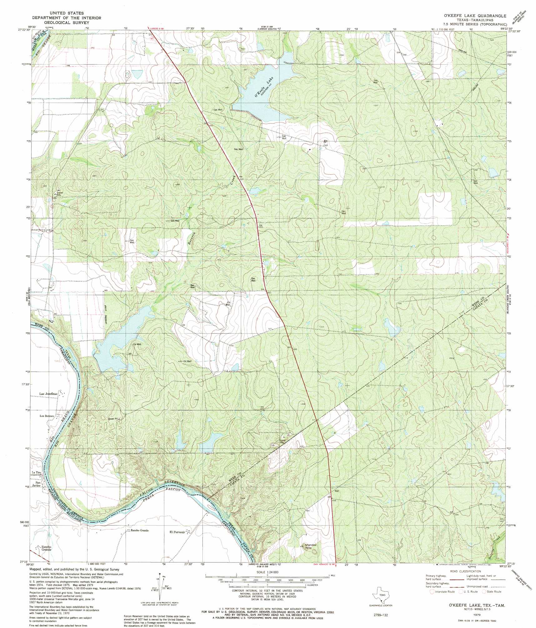
O'Keefe Lake Topo Map Texas
To zoom in, hover over the map of O'Keefe Lake
USGS Topo Quad 27099c4 - 1:24,000 scale
| Topo Map Name: | O'Keefe Lake |
| USGS Topo Quad ID: | 27099c4 |
| Print Size: | ca. 21 1/4" wide x 27" high |
| Southeast Coordinates: | 27.25° N latitude / 99.375° W longitude |
| Map Center Coordinates: | 27.3125° N latitude / 99.4375° W longitude |
| U.S. State: | TX |
| Filename: | o27099c4.jpg |
| Download Map JPG Image: | O'Keefe Lake topo map 1:24,000 scale |
| Map Type: | Topographic |
| Topo Series: | 7.5´ |
| Map Scale: | 1:24,000 |
| Source of Map Images: | United States Geological Survey (USGS) |
| Alternate Map Versions: |
O'Keefe Lake TX 1979, updated 1981 Download PDF Buy paper map O'Keefe Lake TX 2010 Download PDF Buy paper map O'Keefe Lake TX 2013 Download PDF Buy paper map O'Keefe Lake TX 2016 Download PDF Buy paper map |
1:24,000 Topo Quads surrounding O'Keefe Lake
Laredo West |
Laredo East |
Tios Creek |
Burrito Tank |
|
Laredo South |
Blancas Creek North |
Retama Creek |
||
Isla Mesteno |
O'Keefe Lake |
Blancas Creek South |
Agua Azul Creek West |
|
Arroyo Salado West |
Arroyo Salado East |
Las Ovejas Creek |
||
San Ygnacio |
Arroyo Burro |
Mogotes Hill |
> Back to 27099a1 at 1:100,000 scale
> Back to 27098a1 at 1:250,000 scale
> Back to U.S. Topo Maps home
O'Keefe Lake topo map: Gazetteer
O'Keefe Lake: Airports
Rancho Blanco Airport elevation 116m 380′O'Keefe Lake: Dams
La Perla Ranch Lake Number 1 Dam elevation 114m 374′O'Keefe Dam elevation 135m 442′
Zachary Dam elevation 116m 380′
Zachry Lake Number 2 Dam elevation 120m 393′
Zachry Lake Number 3 Dam elevation 118m 387′
O'Keefe Lake: Populated Places
Dolores Colonia elevation 138m 452′El Cenizo elevation 119m 390′
Rio Bravo elevation 124m 406′
Rio Bravo Annex Colonia elevation 119m 390′
Rio Bravo Colonia elevation 122m 400′
O'Keefe Lake: Reservoirs
La Perla Ranch Lake Number 1 elevation 114m 374′Nopalosa Lake elevation 135m 442′
O'Keefe Lake elevation 135m 442′
Rancho Blanco Lake elevation 116m 380′
Zachry Lake Number 2 elevation 120m 393′
Zachry Lake Number 3 elevation 118m 387′
O'Keefe Lake: Streams
Becerra Creek elevation 97m 318′O'Keefe Lake: Summits
Mendez Hills elevation 145m 475′O'Keefe Lake digital topo map on disk
Buy this O'Keefe Lake topo map showing relief, roads, GPS coordinates and other geographical features, as a high-resolution digital map file on DVD: