Piedra Parada Ranch Topo Map Texas
To zoom in, hover over the map of Piedra Parada Ranch
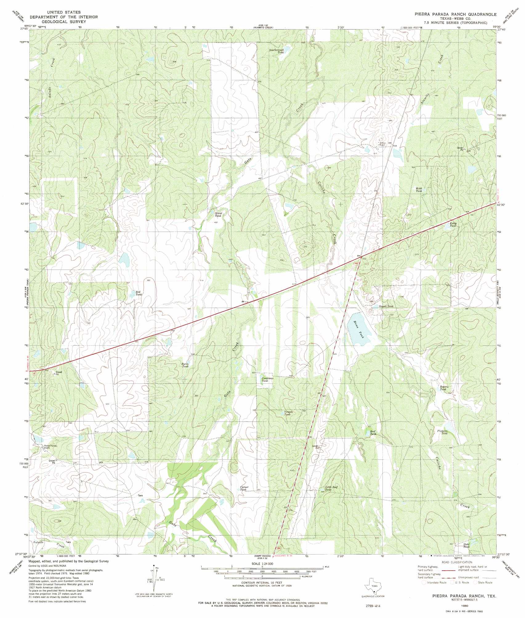
USGS Topo Quad 27099f1 - 1:24,000 scale
| Topo Map Name: | Piedra Parada Ranch |
| USGS Topo Quad ID: | 27099f1 |
| Print Size: | ca. 21 1/4" wide x 27" high |
| Southeast Coordinates: | 27.625° N latitude / 99° W longitude |
| Map Center Coordinates: | 27.6875° N latitude / 99.0625° W longitude |
| U.S. State: | TX |
| Filename: | o27099f1.jpg |
| Download Map JPG Image: | Piedra Parada Ranch topo map 1:24,000 scale |
| Map Type: | Topographic |
| Topo Series: | 7.5´ |
| Map Scale: | 1:24,000 |
| Source of Map Images: | United States Geological Survey (USGS) |
| Alternate Map Versions: |
Piedra Parada Ranch TX 1980, updated 1980 Download PDF Buy paper map Piedra Parada Ranch TX 2010 Download PDF Buy paper map Piedra Parada Ranch TX 2013 Download PDF Buy paper map Piedra Parada Ranch TX 2016 Download PDF Buy paper map |
1:24,000 Topo Quads surrounding Piedra Parada Ranch
Venado Creek West |
Venado Creek East |
Alamito Creek Ne |
Biel Lake North |
Biel Lake Ne |
Callaghan Ranch Se |
Pato Creek |
Alamito Creek |
Biel Lake South |
Biel Lake Se |
Cibolo Ranch |
Piedra Parada Tank |
Piedra Parada Ranch |
Mills Bennett Nw |
Mills Bennett |
Tios Creek |
Burrito Tank |
Shipp Ranch |
Mills Bennett Sw |
San Pablo |
Blancas Creek North |
Retama Creek |
Mirando City |
Oilton |
Bruni |
> Back to 27099e1 at 1:100,000 scale
> Back to 27098a1 at 1:250,000 scale
> Back to U.S. Topo Maps home
Piedra Parada Ranch topo map: Gazetteer
Piedra Parada Ranch: Dams
Lundell Lake Dam elevation 161m 528′Piedra Parada Ranch: Reservoirs
Beatris Tank elevation 165m 541′Beef Tank elevation 166m 544′
Burro Tank elevation 162m 531′
Contreras Tank elevation 160m 524′
Corner Tank elevation 166m 544′
Estep Tank elevation 163m 534′
Home Tank elevation 159m 521′
Little Beef Tank elevation 178m 583′
Lundell Lake elevation 161m 528′
Oliver Tank elevation 149m 488′
Plutarco Tank elevation 169m 554′
Red Tank elevation 162m 531′
Scarborough Tank elevation 144m 472′
Stehl Tank elevation 180m 590′
Steven Tank elevation 165m 541′
Venado Tank elevation 165m 541′
Webb Tank elevation 156m 511′
Piedra Parada Ranch: Streams
Caliche Creek elevation 143m 469′Piedra Parada Ranch digital topo map on disk
Buy this Piedra Parada Ranch topo map showing relief, roads, GPS coordinates and other geographical features, as a high-resolution digital map file on DVD: