Cuervo Creek Topo Map Texas
To zoom in, hover over the map of Cuervo Creek
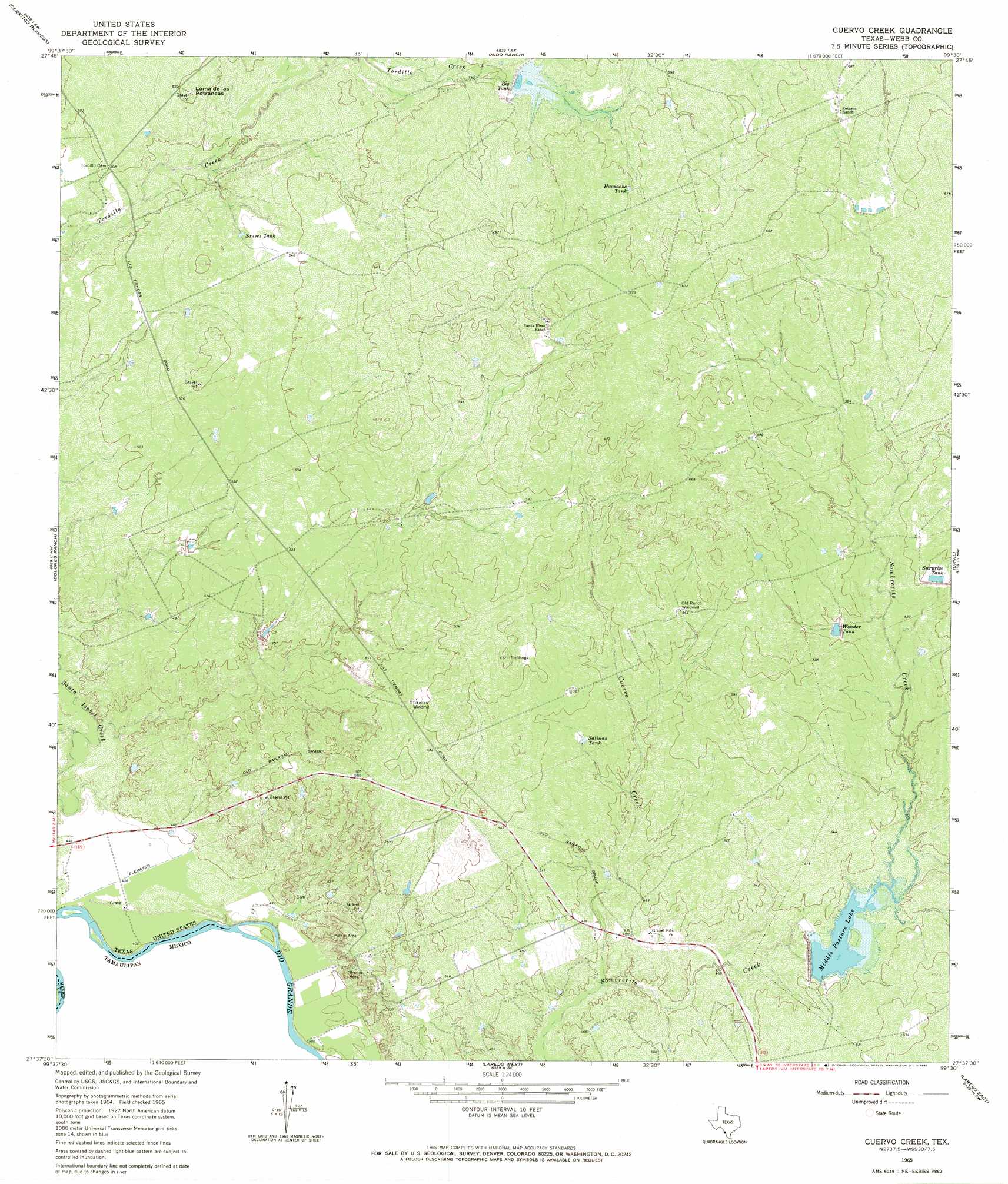
USGS Topo Quad 27099f5 - 1:24,000 scale
| Topo Map Name: | Cuervo Creek |
| USGS Topo Quad ID: | 27099f5 |
| Print Size: | ca. 21 1/4" wide x 27" high |
| Southeast Coordinates: | 27.625° N latitude / 99.5° W longitude |
| Map Center Coordinates: | 27.6875° N latitude / 99.5625° W longitude |
| U.S. State: | TX |
| Filename: | o27099f5.jpg |
| Download Map JPG Image: | Cuervo Creek topo map 1:24,000 scale |
| Map Type: | Topographic |
| Topo Series: | 7.5´ |
| Map Scale: | 1:24,000 |
| Source of Map Images: | United States Geological Survey (USGS) |
| Alternate Map Versions: |
Cuervo Creek TX 1965, updated 1967 Download PDF Buy paper map Cuervo Creek TX 2010 Download PDF Buy paper map Cuervo Creek TX 2013 Download PDF Buy paper map Cuervo Creek TX 2016 Download PDF Buy paper map |
1:24,000 Topo Quads surrounding Cuervo Creek
Pinto Creek |
Las Tiendas |
Spohn Ranch |
Callaghan Ranch North |
Venado Creek West |
San Pedro Hill |
Cerritos Blancos |
Nido Ranch |
Callaghan Ranch South |
Callaghan Ranch Se |
Fort Mcintosh 3 Ne |
Dolores Ranch |
Cuervo Creek |
Orvil |
Cibolo Ranch |
Laredo West |
Laredo East |
Tios Creek |
||
Laredo South |
Blancas Creek North |
> Back to 27099e1 at 1:100,000 scale
> Back to 27098a1 at 1:250,000 scale
> Back to U.S. Topo Maps home
Cuervo Creek topo map: Gazetteer
Cuervo Creek: Dams
Middle Pasture Lake Dam elevation 143m 469′Retama Lake Dam elevation 176m 577′
Cuervo Creek: Populated Places
Antonio Santos Colonia elevation 133m 436′Los Corralitos Colonia elevation 152m 498′
Los Minerales Colonia elevation 133m 436′
Ranchos Penitas West elevation 151m 495′
Ranchos Penitas West Colonia elevation 153m 501′
Cuervo Creek: Reservoirs
Big Tank elevation 169m 554′Huasache Tank elevation 182m 597′
Middle Pasture Lake elevation 151m 495′
Salinas Tank elevation 159m 521′
Sauses Tank elevation 162m 531′
Surprise Tank elevation 162m 531′
Wonder Tank elevation 167m 547′
Cuervo Creek: Streams
Cuervo Creek elevation 131m 429′Cuervo Creek: Summits
Loma de las Potrancas elevation 177m 580′Cuervo Creek digital topo map on disk
Buy this Cuervo Creek topo map showing relief, roads, GPS coordinates and other geographical features, as a high-resolution digital map file on DVD: