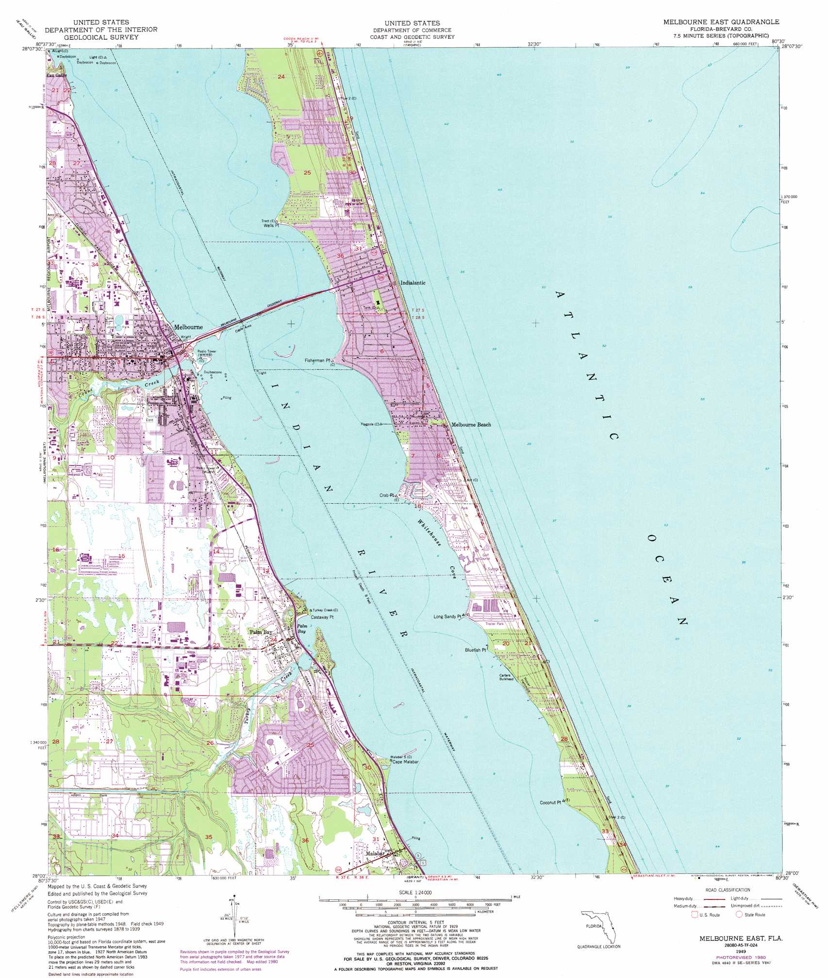
Melbourne East Topo Map Florida
To zoom in, hover over the map of Melbourne East
USGS Topo Quad 28080a5 - 1:24,000 scale
| Topo Map Name: | Melbourne East |
| USGS Topo Quad ID: | 28080a5 |
| Print Size: | ca. 21 1/4" wide x 27" high |
| Southeast Coordinates: | 28° N latitude / 80.5° W longitude |
| Map Center Coordinates: | 28.0625° N latitude / 80.5625° W longitude |
| U.S. State: | FL |
| Filename: | O28080A5.jpg |
| Download Map JPG Image: | Melbourne East topo map 1:24,000 scale |
| Map Type: | Topographic |
| Topo Series: | 7.5´ |
| Map Scale: | 1:24,000 |
| Source of Map Images: | United States Geological Survey (USGS) |
| Alternate Map Versions: |
Melbourne East FL 1949, updated 1960 Download PDF Buy paper map Melbourne East FL 1949, updated 1970 Download PDF Buy paper map Melbourne East FL 1949, updated 1972 Download PDF Buy paper map Melbourne East FL 1949, updated 1981 Download PDF Buy paper map Melbourne East FL 1949, updated 1986 Download PDF Buy paper map Melbourne East FL 1951 Download PDF Buy paper map Melbourne East FL 2012 Download PDF Buy paper map Melbourne East FL 2015 Download PDF Buy paper map |
1:24,000 Topo Quads surrounding Melbourne East
Lake Poinsett |
Cocoa |
Cocoa Beach |
||
Deer Park Ne |
Eau Gallie |
Tropic |
||
Deer Park Se |
Melbourne West |
Melbourne East |
||
Kenansville Ne |
Fellsmere Nw |
Grant |
Sebastian Nw |
|
Kenansville Se |
Fellsmere Sw |
Fellsmere |
Sebastian |
> Back to 28080a1 at 1:100,000 scale
> Back to 28080a1 at 1:250,000 scale
> Back to U.S. Topo Maps home
Melbourne East topo map: Gazetteer
Melbourne East: Airports
Bryan Professional Building Heliport elevation 6m 19′Holmes Regional Medical Center Heliport elevation 4m 13′
Melbourne East: Bays
Indian River Lagoon elevation 0m 0′Palm Bay elevation 0m 0′
Whitehouse Cove elevation 0m 0′
Melbourne East: Capes
Bluefish Point elevation 1m 3′Cape Malabar elevation 0m 0′
Castaway Point elevation 0m 0′
Coconut Point elevation 0m 0′
Crab Point elevation 1m 3′
Fisherman Point elevation 1m 3′
Long Sandy Point elevation 1m 3′
Wells Point elevation 1m 3′
Melbourne East: Dams
Carters Bulkhead elevation 1m 3′Melbourne East: Guts
Turkey Creek elevation 0m 0′Melbourne East: Islands
Mosier Hammock elevation 2m 6′Melbourne East: Lakes
Indian River elevation 0m 0′Melbourne East: Parks
Spessard Holland Park elevation 4m 13′Melbourne East: Populated Places
Bay Pines Mobile Home Park elevation 6m 19′Breezy Palms Mobile Home Park elevation 10m 32′
Camelot Village Mobile Home Park elevation 6m 19′
Enchanted Lakes Estates Mobile Home Park elevation 6m 19′
Hiawatha Mobile Home Park elevation 5m 16′
Hillside Mobile Home Park elevation 6m 19′
Indialantic elevation 4m 13′
Lakewood Village Mobile Home Community elevation 6m 19′
Malabar elevation 7m 22′
Melbourne elevation 6m 19′
Melbourne Beach elevation 3m 9′
Old Fort Trailer Park elevation 4m 13′
Palm Bay elevation 5m 16′
Palm Bay Estates Mobile Home Park elevation 2m 6′
Shearer Trailer Park elevation 6m 19′
Sun Manor Mobile Home Park elevation 9m 29′
Melbourne East: Post Offices
Melbourne Post Office elevation 6m 19′Palm Bay Post Office elevation 6m 19′
Melbourne East: Streams
Crane Creek elevation 0m 0′Melbourne East digital topo map on disk
Buy this Melbourne East topo map showing relief, roads, GPS coordinates and other geographical features, as a high-resolution digital map file on DVD: