Eau Gallie Topo Map Florida
To zoom in, hover over the map of Eau Gallie
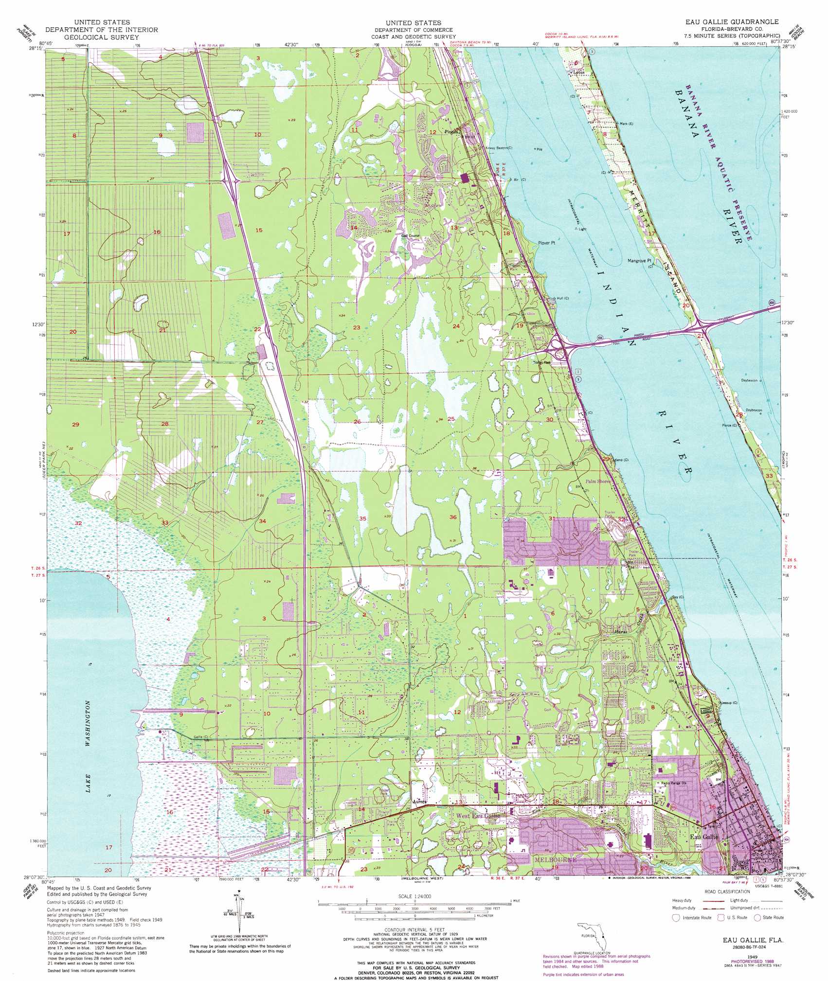
USGS Topo Quad 28080b6 - 1:24,000 scale
| Topo Map Name: | Eau Gallie |
| USGS Topo Quad ID: | 28080b6 |
| Print Size: | ca. 21 1/4" wide x 27" high |
| Southeast Coordinates: | 28.125° N latitude / 80.625° W longitude |
| Map Center Coordinates: | 28.1875° N latitude / 80.6875° W longitude |
| U.S. State: | FL |
| Filename: | O28080B6.jpg |
| Download Map JPG Image: | Eau Gallie topo map 1:24,000 scale |
| Map Type: | Topographic |
| Topo Series: | 7.5´ |
| Map Scale: | 1:24,000 |
| Source of Map Images: | United States Geological Survey (USGS) |
| Alternate Map Versions: |
Eau Gallie FL 1949, updated 1960 Download PDF Buy paper map Eau Gallie FL 1949, updated 1968 Download PDF Buy paper map Eau Gallie FL 1949, updated 1971 Download PDF Buy paper map Eau Gallie FL 1949, updated 1975 Download PDF Buy paper map Eau Gallie FL 1949, updated 1981 Download PDF Buy paper map Eau Gallie FL 1949, updated 1988 Download PDF Buy paper map Eau Gallie FL 1951 Download PDF Buy paper map Eau Gallie FL 2012 Download PDF Buy paper map Eau Gallie FL 2015 Download PDF Buy paper map |
1:24,000 Topo Quads surrounding Eau Gallie
Lake Poinsett Nw |
Sharpes |
Courtenay |
Cape Canaveral |
|
Lake Poinsett Sw |
Lake Poinsett |
Cocoa |
Cocoa Beach |
|
Deer Park Nw |
Deer Park Ne |
Eau Gallie |
Tropic |
|
Deer Park |
Deer Park Se |
Melbourne West |
Melbourne East |
|
Kenansville |
Kenansville Ne |
Fellsmere Nw |
Grant |
Sebastian Nw |
> Back to 28080a1 at 1:100,000 scale
> Back to 28080a1 at 1:250,000 scale
> Back to U.S. Topo Maps home
Eau Gallie topo map: Gazetteer
Eau Gallie: Airports
Nierenberg Estate Heliport elevation 10m 32′Eau Gallie: Bridges
Pineda Causeway elevation 0m 0′Eau Gallie: Capes
Mangrove Point elevation 0m 0′Plover Point elevation 0m 0′
Eau Gallie: Lakes
Lake Washington elevation 5m 16′Eau Gallie: Populated Places
Aurora elevation 7m 22′Aurora Park Mobile Home Park elevation 6m 19′
Aurora Pines Mobile Home Park elevation 7m 22′
Big Oak Trailer Park elevation 7m 22′
Broadview Mobile Home Park elevation 6m 19′
Eau Gallie elevation 6m 19′
Happy Acres Mobile Home Park elevation 7m 22′
Harbor Mobile Home Park elevation 6m 19′
Hibiscus Mobile Haven elevation 7m 22′
Hollandale Mobile Home Park elevation 6m 19′
Indian River Trailer Park elevation 6m 19′
Johnson Mobile Home Park elevation 6m 19′
Lantern Village Mobile Home Park elevation 6m 19′
Lotus elevation 0m 0′
Mobiland by the Sea elevation 5m 16′
Orange Trailer Manor Mobile Home Park elevation 6m 19′
Palm Shores elevation 4m 13′
Pineda elevation 8m 26′
Rachels Mobile Home Park elevation 7m 22′
Riverview Manufactured Home Community elevation 7m 22′
Rocky Water Park Mobile Home Park elevation 6m 19′
Shady Oak Mobile Home Park elevation 6m 19′
Sherman Park elevation 6m 19′
Tan Tara Mobile Home Park elevation 6m 19′
Viera elevation 7m 22′
Village Glen Mobile Home Park elevation 7m 22′
West Eau Gallie elevation 6m 19′
Eau Gallie: Post Offices
Eau Gallie Station Post Office elevation 5m 16′Suntree Post Office elevation 7m 22′
Eau Gallie: Streams
Horse Creek elevation 0m 0′Eau Gallie digital topo map on disk
Buy this Eau Gallie topo map showing relief, roads, GPS coordinates and other geographical features, as a high-resolution digital map file on DVD: