Cocoa Topo Map Florida
To zoom in, hover over the map of Cocoa
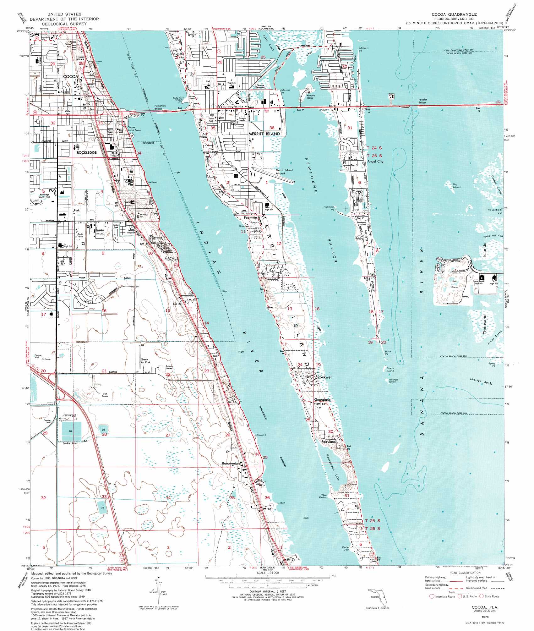
USGS Topo Quad 28080c6 - 1:24,000 scale
| Topo Map Name: | Cocoa |
| USGS Topo Quad ID: | 28080c6 |
| Print Size: | ca. 21 1/4" wide x 27" high |
| Southeast Coordinates: | 28.25° N latitude / 80.625° W longitude |
| Map Center Coordinates: | 28.3125° N latitude / 80.6875° W longitude |
| U.S. State: | FL |
| Filename: | O28080C6.jpg |
| Download Map JPG Image: | Cocoa topo map 1:24,000 scale |
| Map Type: | Topographic |
| Topo Series: | 7.5´ |
| Map Scale: | 1:24,000 |
| Source of Map Images: | United States Geological Survey (USGS) |
| Alternate Map Versions: |
Cocoa FL 1949, updated 1962 Download PDF Buy paper map Cocoa FL 1949, updated 1970 Download PDF Buy paper map Cocoa FL 1951 Download PDF Buy paper map Cocoa FL 1976, updated 1977 Download PDF Buy paper map Cocoa FL 1976, updated 1990 Download PDF Buy paper map Cocoa FL 2012 Download PDF Buy paper map Cocoa FL 2015 Download PDF Buy paper map |
1:24,000 Topo Quads surrounding Cocoa
Titusville Sw |
Titusville |
Orsino |
False Cape |
|
Lake Poinsett Nw |
Sharpes |
Courtenay |
Cape Canaveral |
|
Lake Poinsett Sw |
Lake Poinsett |
Cocoa |
Cocoa Beach |
|
Deer Park Nw |
Deer Park Ne |
Eau Gallie |
Tropic |
|
Deer Park |
Deer Park Se |
Melbourne West |
Melbourne East |
> Back to 28080a1 at 1:100,000 scale
> Back to 28080a1 at 1:250,000 scale
> Back to U.S. Topo Maps home
Cocoa topo map: Gazetteer
Cocoa: Airports
Merritt Island Airport elevation 0m 0′Rockledge Airpark elevation 7m 22′
Wuesthoff Hospital Emergency Heliport elevation 6m 19′
Cocoa: Bays
Catfish Creek elevation 0m 0′Jones Creek elevation 0m 0′
Cocoa: Bridges
Hubert H Humphrey Bridge elevation 0m 0′Peebles Bridge elevation 0m 0′
Cocoa: Canals
Faulk Canal elevation 6m 19′Cocoa: Capes
Buck Point elevation 0m 0′Cape Cod elevation 0m 0′
Horti Point elevation 0m 0′
Merritt Point elevation 0m 0′
Milford Point elevation 0m 0′
Pullman Point elevation 0m 0′
The Point elevation 0m 0′
Cocoa: Channels
Houseboat Cut elevation 0m 0′Cocoa: Harbors
Cocoa Yacht Basin elevation 0m 0′Cocoa: Islands
Big Island elevation 0m 0′Brady Island elevation 0m 0′
Georges Island elevation 0m 0′
Kiwanis Island elevation 1m 3′
Meritt Island elevation 1m 3′
Thousand Islands elevation 0m 0′
Cocoa: Lakes
Banana River elevation 0m 0′Honeymoon Lake elevation 0m 0′
Cocoa: Parks
Banana River Aquatic Preserve elevation 0m 0′Cocoa: Populated Places
Angel City elevation 0m 0′Bonaventure elevation 5m 16′
Byrd Plaza Mobile Home Park elevation 11m 36′
Central Mobile Home Park elevation 7m 22′
Footman elevation 1m 3′
Georgiana elevation 3m 9′
Harbour Mobile Home Park elevation 7m 22′
Imperial Trailer Court elevation 2m 6′
Indian Oaks Trailer Park elevation 6m 19′
Merritt Island Village Resort Mobile Home Park elevation 0m 0′
Oak Mobile Home Park elevation 9m 29′
River Haven Mobile Home Park elevation 2m 6′
River Palms Mobile Home Park elevation 0m 0′
Rockledge elevation 7m 22′
Rockwell elevation 1m 3′
Siesta Mobile Home Park elevation 2m 6′
Tropical Mobile Manor Park elevation 2m 6′
Cocoa: Post Offices
Five Points Post Office elevation 7m 22′Rockledge Post Office elevation 7m 22′
Cocoa: Reservoirs
Black Dog Lake elevation 7m 22′Cocoa: Streams
Crane Creek elevation 0m 0′Cocoa: Summits
Honeymoon Hill elevation 10m 32′Cocoa digital topo map on disk
Buy this Cocoa topo map showing relief, roads, GPS coordinates and other geographical features, as a high-resolution digital map file on DVD: