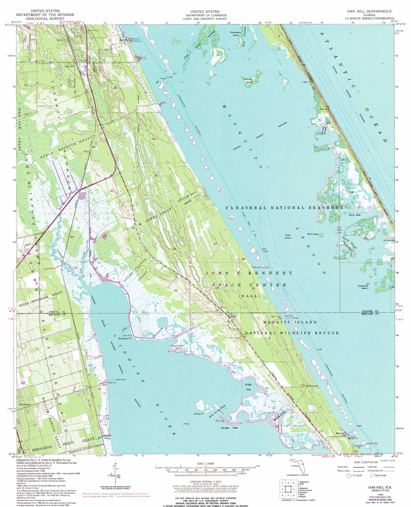
Oak Hill Topo Map Florida
To zoom in, hover over the map of Oak Hill
USGS Topo Quad 28080g7 - 1:24,000 scale
| Topo Map Name: | Oak Hill |
| USGS Topo Quad ID: | 28080g7 |
| Print Size: | ca. 21 1/4" wide x 27" high |
| Southeast Coordinates: | 28.75° N latitude / 80.75° W longitude |
| Map Center Coordinates: | 28.8125° N latitude / 80.8125° W longitude |
| U.S. State: | FL |
| Filename: | O28080G7.jpg |
| Download Map JPG Image: | Oak Hill topo map 1:24,000 scale |
| Map Type: | Topographic |
| Topo Series: | 7.5´ |
| Map Scale: | 1:24,000 |
| Source of Map Images: | United States Geological Survey (USGS) |
| Alternate Map Versions: |
Oak Hill FL 1949, updated 1952 Download PDF Buy paper map Oak Hill FL 1949, updated 1962 Download PDF Buy paper map Oak Hill FL 1949, updated 1968 Download PDF Buy paper map Oak Hill FL 1949, updated 1972 Download PDF Buy paper map Oak Hill FL 1949, updated 1984 Download PDF Buy paper map Oak Hill FL 1949, updated 1993 Download PDF Buy paper map Oak Hill FL 1949, updated 1997 Download PDF Buy paper map Oak Hill FL 2012 Download PDF Buy paper map Oak Hill FL 2015 Download PDF Buy paper map |
1:24,000 Topo Quads surrounding Oak Hill
Samsula |
New Smyrna Beach |
|||
Lake Ashby |
Edgewater |
Ariel |
||
Osceola |
Maytown |
Oak Hill |
Pardon Island |
|
Geneva |
Aurantia |
Mims |
Wilson |
|
Bithlo |
Titusville Sw |
Titusville |
Orsino |
False Cape |
> Back to 28080e1 at 1:100,000 scale
> Back to 28080a1 at 1:250,000 scale
> Back to U.S. Topo Maps home
Oak Hill topo map: Gazetteer
Oak Hill: Airports
Tradewinds Aerodrome elevation 1m 3′Oak Hill: Bays
Georges Slough elevation 0m 0′Glory Hole elevation 0m 0′
Griffis Bay elevation 0m 0′
Tiger Shoal elevation 0m 0′
Oak Hill: Beaches
Apollo Beach elevation 6m 19′Oak Hill: Capes
Boathouse Point elevation 0m 0′Grassy Point elevation 0m 0′
Oak Hill: Channels
East Channel elevation 0m 0′Hole in the Wall elevation 0m 0′
Oak Hill: Flats
Georges Flats elevation 0m 0′Oak Hill: Guts
Vanns Slough elevation 0m 0′Oak Hill: Islands
Bird Island elevation 0m 0′Cat Hammock elevation 0m 0′
Middle Island elevation 0m 0′
Onion Farm Island elevation 0m 0′
Plantation Island elevation 0m 0′
Preachers Island elevation 0m 0′
Vanns Island elevation 0m 0′
Oak Hill: Lakes
Mosquito Lagoon elevation 0m 0′Oak Hill: Parks
Mosquito Lagoon Aquatic Preserve elevation 0m 0′Oak Hill: Populated Places
Kings Trailer Park elevation 3m 9′Oak Hill elevation 4m 13′
Oak Hill Association Mobile Home Park elevation 0m 0′
Oak Hill Trailer Park elevation 3m 9′
Orange Blossom Trailer Park elevation 3m 9′
Shiloh elevation 4m 13′
South Mobile Village elevation 6m 19′
Oak Hill: Post Offices
Oak Hill Post Office elevation 6m 19′Oak Hill: Streams
Big Flounder Creek elevation 0m 0′Coot Creek elevation 0m 0′
Pattillo Creek elevation 0m 0′
Turnbull Creek elevation 0m 0′
Oak Hill: Summits
Bull Hill elevation 4m 13′Oak Hill digital topo map on disk
Buy this Oak Hill topo map showing relief, roads, GPS coordinates and other geographical features, as a high-resolution digital map file on DVD: