Lake Hatchineha Topo Map Florida
To zoom in, hover over the map of Lake Hatchineha
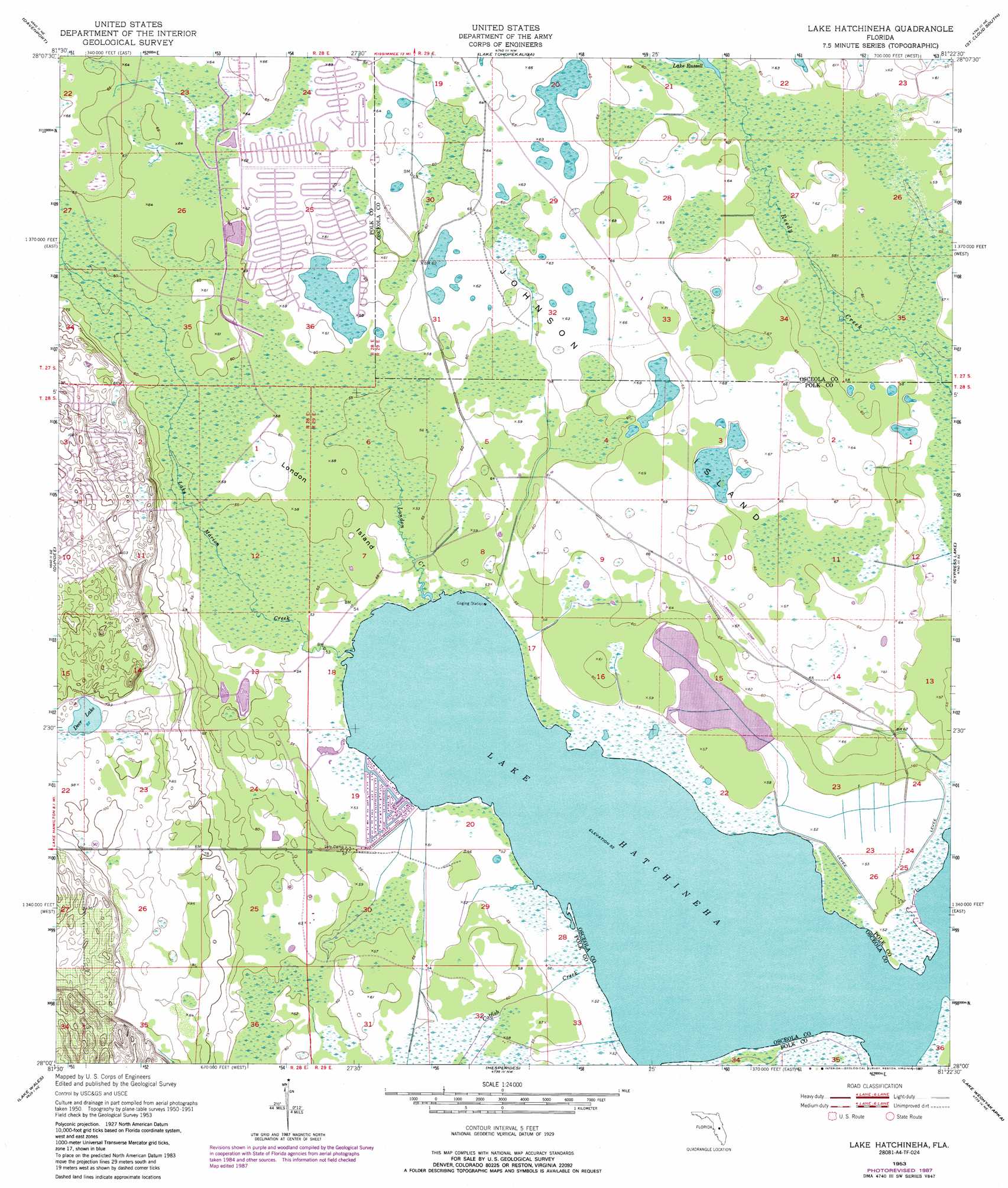
USGS Topo Quad 28081a4 - 1:24,000 scale
| Topo Map Name: | Lake Hatchineha |
| USGS Topo Quad ID: | 28081a4 |
| Print Size: | ca. 21 1/4" wide x 27" high |
| Southeast Coordinates: | 28° N latitude / 81.375° W longitude |
| Map Center Coordinates: | 28.0625° N latitude / 81.4375° W longitude |
| U.S. State: | FL |
| Filename: | O28081A4.jpg |
| Download Map JPG Image: | Lake Hatchineha topo map 1:24,000 scale |
| Map Type: | Topographic |
| Topo Series: | 7.5´ |
| Map Scale: | 1:24,000 |
| Source of Map Images: | United States Geological Survey (USGS) |
| Alternate Map Versions: |
Lake Hatchineha FL 1953, updated 1954 Download PDF Buy paper map Lake Hatchineha FL 1953, updated 1968 Download PDF Buy paper map Lake Hatchineha FL 1953, updated 1981 Download PDF Buy paper map Lake Hatchineha FL 1953, updated 1987 Download PDF Buy paper map Lake Hatchineha FL 2012 Download PDF Buy paper map Lake Hatchineha FL 2015 Download PDF Buy paper map |
1:24,000 Topo Quads surrounding Lake Hatchineha
Lake Louisa Sw |
Intercession City |
Kissimmee |
Saint Cloud North |
Narcoossee |
Gum Lake |
Davenport |
Lake Tohopekaliga |
Saint Cloud South |
Ashton |
Winter Haven |
Dundee |
Lake Hatchineha |
Cypress Lake |
Holopaw Sw |
Eloise |
Lake Wales |
Hesperides |
Lake Weohyakapka Ne |
Lake Marian Nw |
Alturas |
Babson Park |
Lake Weohyakapka |
Lake Weohyakpka Se |
Lake Marian Sw |
> Back to 28081a1 at 1:100,000 scale
> Back to 28080a1 at 1:250,000 scale
> Back to U.S. Topo Maps home
Lake Hatchineha topo map: Gazetteer
Lake Hatchineha: Airports
Walker Ranch-Private Airport elevation 20m 65′Lake Hatchineha: Islands
Johnson Island elevation 20m 65′London Island elevation 17m 55′
Lake Hatchineha: Lakes
Deer Lake elevation 28m 91′Lake Hatchineha elevation 16m 52′
Lake Hatchineha: Parks
Allen David Broussard Catfish Creek Preserve State Park elevation 18m 59′Lake Hatchineha: Streams
Catfish Creek elevation 16m 52′Lake Marion Creek elevation 16m 52′
London Creek elevation 16m 52′
Lake Hatchineha digital topo map on disk
Buy this Lake Hatchineha topo map showing relief, roads, GPS coordinates and other geographical features, as a high-resolution digital map file on DVD: