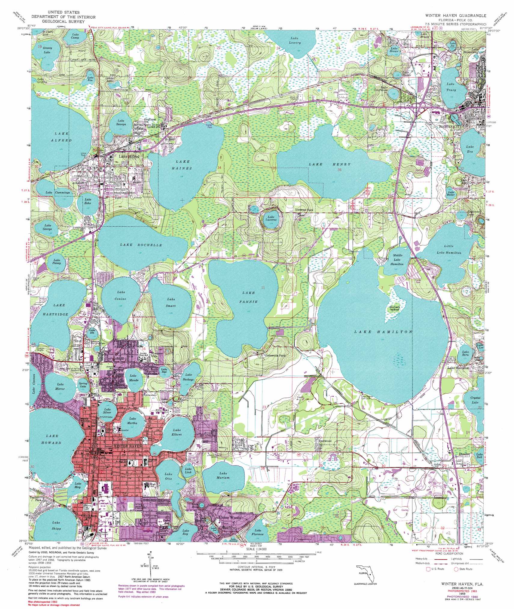
Winter Haven Topo Map Florida
To zoom in, hover over the map of Winter Haven
USGS Topo Quad 28081a6 - 1:24,000 scale
| Topo Map Name: | Winter Haven |
| USGS Topo Quad ID: | 28081a6 |
| Print Size: | ca. 21 1/4" wide x 27" high |
| Southeast Coordinates: | 28° N latitude / 81.625° W longitude |
| Map Center Coordinates: | 28.0625° N latitude / 81.6875° W longitude |
| U.S. State: | FL |
| Filename: | O28081A6.jpg |
| Download Map JPG Image: | Winter Haven topo map 1:24,000 scale |
| Map Type: | Topographic |
| Topo Series: | 7.5´ |
| Map Scale: | 1:24,000 |
| Source of Map Images: | United States Geological Survey (USGS) |
| Alternate Map Versions: |
Winter Haven FL 1959, updated 1961 Download PDF Buy paper map Winter Haven FL 1959, updated 1972 Download PDF Buy paper map Winter Haven FL 1959, updated 1981 Download PDF Buy paper map Winter Haven FL 1959, updated 1988 Download PDF Buy paper map Winter Haven FL 2012 Download PDF Buy paper map Winter Haven FL 2015 Download PDF Buy paper map |
1:24,000 Topo Quads surrounding Winter Haven
Rock Ridge |
Poyner |
Lake Louisa Sw |
Intercession City |
Kissimmee |
Providence |
Polk City |
Gum Lake |
Davenport |
Lake Tohopekaliga |
Lakeland |
Auburndale |
Winter Haven |
Dundee |
Lake Hatchineha |
Mulberry |
Bartow |
Eloise |
Lake Wales |
Hesperides |
Bradley Junction |
Homeland |
Alturas |
Babson Park |
Lake Weohyakapka |
> Back to 28081a1 at 1:100,000 scale
> Back to 28080a1 at 1:250,000 scale
> Back to U.S. Topo Maps home
Winter Haven topo map: Gazetteer
Winter Haven: Airports
Lake Hamilton Seaplane Base elevation 38m 124′Lazy B I Ranch Heliport elevation 39m 127′
Winter Haven Hospital Heliport elevation 43m 141′
Winter Haven: Islands
Bonars Island elevation 37m 121′Winter Haven: Lakes
Crystal Lake elevation 37m 121′Engineers Lake elevation 37m 121′
Grass Lake elevation 41m 134′
Grassy Lake elevation 40m 131′
Lake Alfred elevation 39m 127′
Lake Boomerang elevation 36m 118′
Lake Brown elevation 39m 127′
Lake Buckeye elevation 39m 127′
Lake Butler elevation 37m 121′
Lake Camp elevation 40m 131′
Lake Confusion elevation 39m 127′
Lake Conine elevation 39m 127′
Lake Connie elevation 39m 127′
Lake Cummings elevation 40m 131′
Lake Dell elevation 37m 121′
Lake Echo elevation 40m 131′
Lake Elbert elevation 41m 134′
Lake Elizabeth elevation 38m 124′
Lake Elsie elevation 38m 124′
Lake Eva elevation 37m 121′
Lake Fannie elevation 38m 124′
Lake Florence elevation 39m 127′
Lake Gem elevation 42m 137′
Lake George elevation 40m 131′
Lake Haines elevation 39m 127′
Lake Hamilton elevation 37m 121′
Lake Hartridge elevation 40m 131′
Lake Henry elevation 38m 124′
Lake Hester elevation 39m 127′
Lake Howard elevation 40m 131′
Lake Ida elevation 41m 134′
Lake Ida elevation 38m 124′
Lake Idyl elevation 41m 134′
Lake Ina elevation 39m 127′
Lake Joe elevation 38m 124′
Lake Lee elevation 37m 121′
Lake Link elevation 39m 127′
Lake Lucerne elevation 39m 127′
Lake Mariam elevation 39m 127′
Lake Martha elevation 43m 141′
Lake Maude elevation 43m 141′
Lake May elevation 40m 131′
Lake Mirror elevation 40m 131′
Lake Otis elevation 39m 127′
Lake Pansy elevation 39m 127′
Lake Rey elevation 41m 134′
Lake Ring elevation 39m 127′
Lake Rochelle elevation 39m 127′
Lake Roy elevation 40m 131′
Lake Sara elevation 37m 121′
Lake Sard elevation 37m 121′
Lake Shipp elevation 40m 131′
Lake Silver elevation 44m 144′
Lake Smart elevation 39m 127′
Lake Swoope elevation 40m 131′
Lake Tracy elevation 38m 124′
Little Lake Hamilton elevation 37m 121′
Middle Lake Hamilton elevation 37m 121′
Spring Lake elevation 40m 131′
Winter Haven: Parks
Boomerang Park elevation 39m 127′Inman Park elevation 51m 167′
Lake Eva Park elevation 40m 131′
Lions Park elevation 42m 137′
Railroad Park elevation 49m 160′
Rotary Park elevation 43m 141′
Winter Haven: Populated Places
Central Park of Haines City Mobile Home Park elevation 47m 154′Cypress Gardens Mobile Home Park elevation 38m 124′
Cypress Greens Mobile Home Park elevation 41m 134′
Eastwood elevation 40m 131′
Eloise Woods elevation 51m 167′
Fairview Village Mobile Home Park elevation 40m 131′
Fletchers Mobile Home Park elevation 41m 134′
Florence Villa elevation 44m 144′
Haines City Mobile Home Park elevation 38m 124′
Haines Haven Mobile Park elevation 40m 131′
Heartland Estates Mobile Home Park elevation 38m 124′
Hidden Cove East Mobile Home Park elevation 40m 131′
Hidden Cove Mobile Home Park elevation 39m 127′
Hidden Cove West Mobile Home Park elevation 40m 131′
Hidden Golf Club Mobile Home Park elevation 42m 137′
Johnson Mobile Home Park elevation 40m 131′
Kennard Mobile Park elevation 40m 131′
Kings Pointe Mobile Home Park elevation 45m 147′
Lake Alfred elevation 53m 173′
Lake Alfred Mobile Home Park elevation 40m 131′
Lake Hamilton elevation 45m 147′
Lake Ida Mobile Home Park elevation 42m 137′
Lucerne Lakeside Manufactured Home Community elevation 42m 137′
Lucerne Park elevation 49m 160′
Minerva Mobile Home Park elevation 40m 131′
Palm Shores Mobile Village elevation 40m 131′
Plantation Landings Mobile Home Park elevation 40m 131′
Poinsettia Park elevation 47m 154′
Royal Oaks Mobile Home Resort elevation 37m 121′
Royal Palm Village Mobile Home Park elevation 40m 131′
Shipp Side Mobile Home Park elevation 42m 137′
Swiss Golf and Tennis Club Mobile Home Park elevation 40m 131′
Swiss Village Mobile Home Park elevation 43m 141′
Tranquility Park elevation 43m 141′
Winter Haven elevation 51m 167′
Woodland Lakes Mobile Home Park elevation 40m 131′
Winter Haven: Post Offices
Florence Villa Post Office (historical) elevation 44m 144′Lake Alfred Post Office elevation 52m 170′
Winter Haven Post Office elevation 54m 177′
Winter Haven: Swamps
Lake Alice elevation 37m 121′Winter Haven digital topo map on disk
Buy this Winter Haven topo map showing relief, roads, GPS coordinates and other geographical features, as a high-resolution digital map file on DVD: