Providence Topo Map Florida
To zoom in, hover over the map of Providence
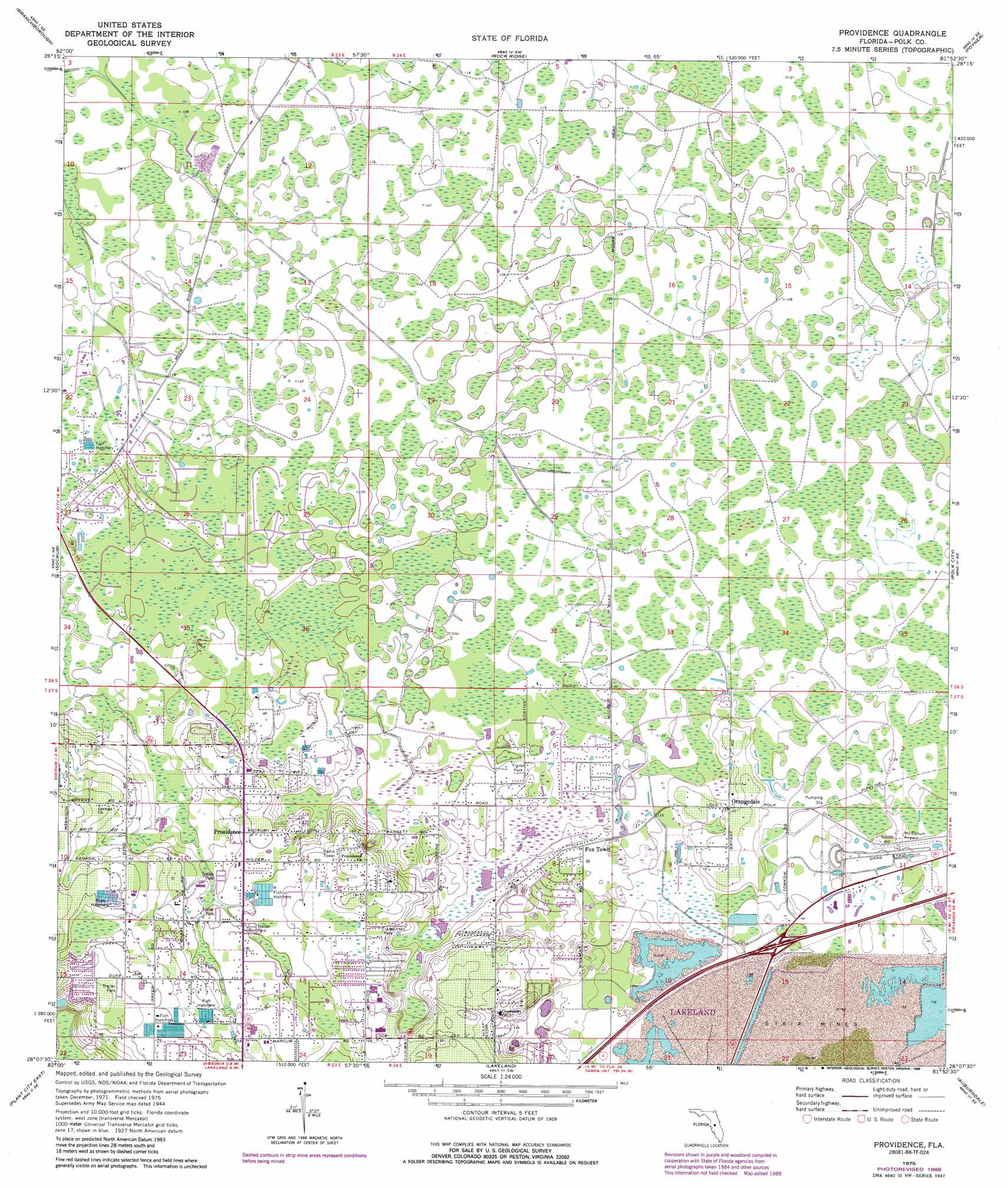
USGS Topo Quad 28081b8 - 1:24,000 scale
| Topo Map Name: | Providence |
| USGS Topo Quad ID: | 28081b8 |
| Print Size: | ca. 21 1/4" wide x 27" high |
| Southeast Coordinates: | 28.125° N latitude / 81.875° W longitude |
| Map Center Coordinates: | 28.1875° N latitude / 81.9375° W longitude |
| U.S. State: | FL |
| Filename: | O28081B8.jpg |
| Download Map JPG Image: | Providence topo map 1:24,000 scale |
| Map Type: | Topographic |
| Topo Series: | 7.5´ |
| Map Scale: | 1:24,000 |
| Source of Map Images: | United States Geological Survey (USGS) |
| Alternate Map Versions: |
Providence FL 1944, updated 1963 Download PDF Buy paper map Providence FL 1975, updated 1976 Download PDF Buy paper map Providence FL 1975, updated 1988 Download PDF Buy paper map Providence FL 1975, updated 1988 Download PDF Buy paper map Providence FL 2012 Download PDF Buy paper map Providence FL 2015 Download PDF Buy paper map |
1:24,000 Topo Quads surrounding Providence
Lacoochee |
Clay Sink |
Bay Lake |
Lake Nellie |
Lake Louisa |
Dade City |
Branchborough |
Rock Ridge |
Poyner |
Lake Louisa Sw |
Zephyrhills |
Socrum |
Providence |
Polk City |
Gum Lake |
Plant City West |
Plant City East |
Lakeland |
Auburndale |
Winter Haven |
Dover |
Nichols |
Mulberry |
Bartow |
Eloise |
> Back to 28081a1 at 1:100,000 scale
> Back to 28080a1 at 1:250,000 scale
> Back to U.S. Topo Maps home
Providence topo map: Gazetteer
Providence: Airports
Green Swamp Aerodrome elevation 34m 111′Lake Gibson High School Heliport elevation 50m 164′
Providence: Lakes
Country Oaks Lake elevation 37m 121′Duff Lake elevation 48m 157′
Hidden Lake elevation 37m 121′
Lake Bowles elevation 39m 127′
Lake Cameron elevation 39m 127′
Lake Ennis elevation 40m 131′
Lake French elevation 39m 127′
Saint Andrews Lake elevation 39m 127′
Sherwood Forest Lake elevation 40m 131′
Sick Lake elevation 40m 131′
Sick Lake elevation 37m 121′
Providence: Populated Places
Duff Meadows Mobile Home Park elevation 47m 154′Fox Town elevation 41m 134′
Greenbrier Mobile Home Park elevation 56m 183′
Kern Mobile Estates elevation 43m 141′
Martin Estates Mobile Home Park elevation 48m 157′
Orangedale elevation 42m 137′
Pine Lake Mobile Home Park elevation 45m 147′
Pleasant Ridge Mobile Home Park elevation 40m 131′
Providence elevation 45m 147′
Smokey Valley Mobile Home Park elevation 41m 134′
Southwinds Mobile Home Park elevation 44m 144′
Sundance Mobile Home Park elevation 43m 141′
Providence digital topo map on disk
Buy this Providence topo map showing relief, roads, GPS coordinates and other geographical features, as a high-resolution digital map file on DVD: