Saint Cloud North Topo Map Florida
To zoom in, hover over the map of Saint Cloud North
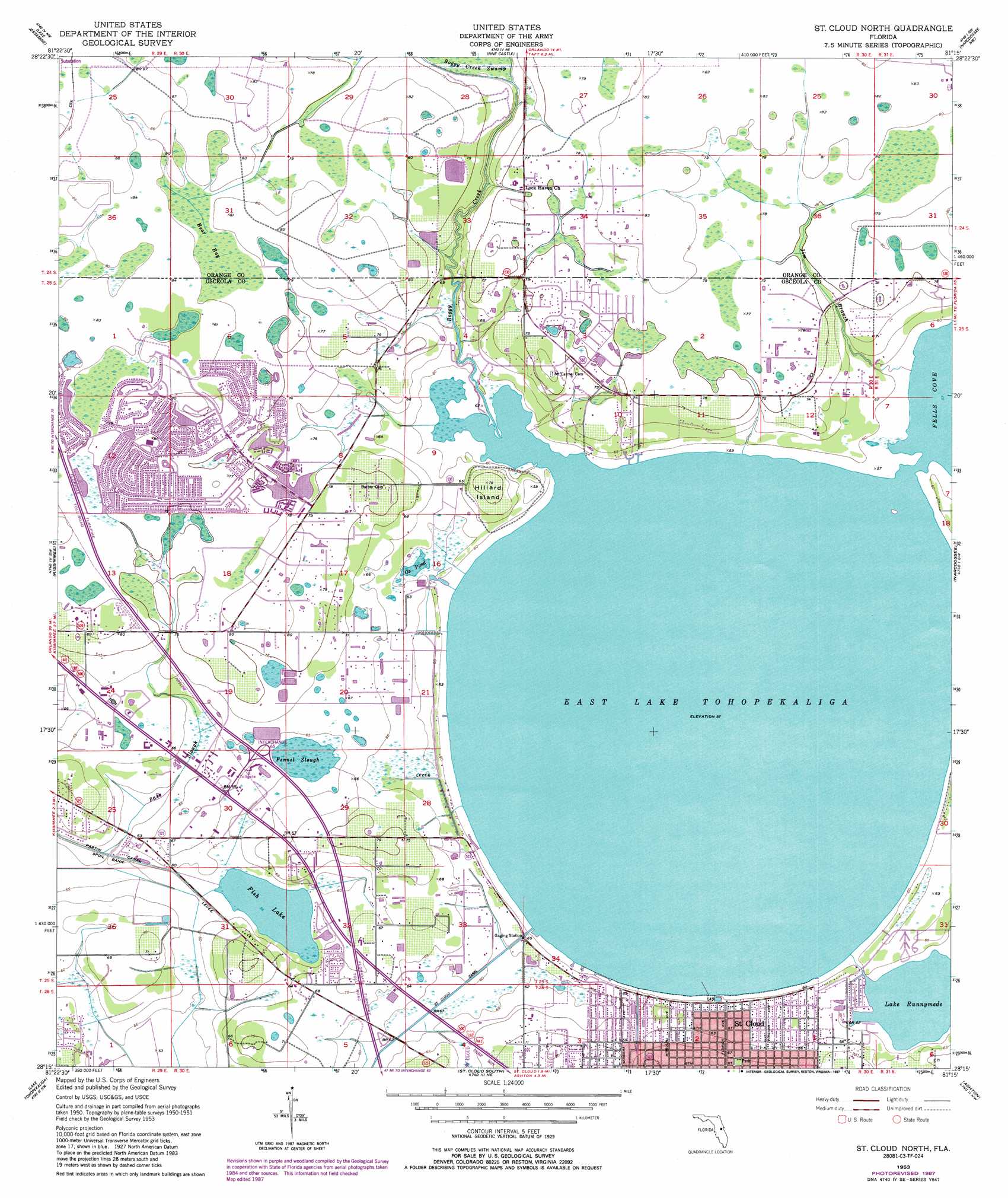
USGS Topo Quad 28081c3 - 1:24,000 scale
| Topo Map Name: | Saint Cloud North |
| USGS Topo Quad ID: | 28081c3 |
| Print Size: | ca. 21 1/4" wide x 27" high |
| Southeast Coordinates: | 28.25° N latitude / 81.25° W longitude |
| Map Center Coordinates: | 28.3125° N latitude / 81.3125° W longitude |
| U.S. State: | FL |
| Filename: | O28081C3.jpg |
| Download Map JPG Image: | Saint Cloud North topo map 1:24,000 scale |
| Map Type: | Topographic |
| Topo Series: | 7.5´ |
| Map Scale: | 1:24,000 |
| Source of Map Images: | United States Geological Survey (USGS) |
| Alternate Map Versions: |
St Cloud North FL 1953, updated 1954 Download PDF Buy paper map St Cloud North FL 1953, updated 1972 Download PDF Buy paper map St Cloud North FL 1953, updated 1976 Download PDF Buy paper map St. Cloud North FL 1953, updated 1981 Download PDF Buy paper map St Cloud North FL 1953, updated 1987 Download PDF Buy paper map St Cloud North FL 1953, updated 1987 Download PDF Buy paper map Saint Cloud North FL 2012 Download PDF Buy paper map Saint Cloud North FL 2015 Download PDF Buy paper map |
1:24,000 Topo Quads surrounding Saint Cloud North
Winter Garden |
Orlando West |
Orlando East |
Oviedo Sw |
Bithlo |
Windermere |
Lake Jessamine |
Pine Castle |
Narcoossee Nw |
Narcoossee Ne |
Intercession City |
Kissimmee |
Saint Cloud North |
Narcoossee |
Narcoossee Se |
Davenport |
Lake Tohopekaliga |
Saint Cloud South |
Ashton |
Holopaw |
Dundee |
Lake Hatchineha |
Cypress Lake |
Holopaw Sw |
Holopaw Se |
> Back to 28081a1 at 1:100,000 scale
> Back to 28080a1 at 1:250,000 scale
> Back to U.S. Topo Maps home
Saint Cloud North topo map: Gazetteer
Saint Cloud North: Airports
Big Sky Airpark elevation 18m 59′East Lake Seaplane Base elevation 17m 55′
Frog Wells Airport elevation 20m 65′
Osceola Sheriff's Office Bronson Highway Heliport elevation 19m 62′
Saint Cloud North: Canals
Partin Canal elevation 17m 55′Saint Cloud Canal elevation 18m 59′
Saint Cloud North: Guts
Fennel Slough elevation 19m 62′Saint Cloud North: Islands
Hillard Island elevation 23m 75′Saint Cloud North: Lakes
East Lake Tohopekaliga elevation 17m 55′Fish Lake elevation 17m 55′
Lake Runnymede elevation 17m 55′
Ox Pond elevation 18m 59′
Saint Cloud North: Populated Places
Buenaventura Lakes elevation 24m 78′Jade Isles Trailer Park elevation 18m 59′
Lake Runnymede Mobile Home Park elevation 19m 62′
Sand Hill Cove Mobile Home Park elevation 18m 59′
Sugar Mill Mobile Home Park elevation 19m 62′
Tohopikaliga (historical) elevation 17m 55′
Williams Trailer Park elevation 20m 65′
Saint Cloud North: Post Offices
Buena Ventura Lakes Post Office elevation 23m 75′Saint Cloud North: Streams
Bass Slough elevation 17m 55′Boggy Creek elevation 17m 55′
Jim Branch elevation 17m 55′
Saint Cloud North: Swamps
Bear Bay elevation 24m 78′Saint Cloud North digital topo map on disk
Buy this Saint Cloud North topo map showing relief, roads, GPS coordinates and other geographical features, as a high-resolution digital map file on DVD: