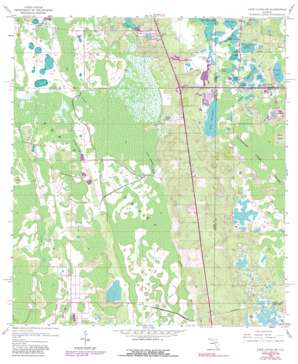
Lake Louisa Sw Topo Map Florida
To zoom in, hover over the map of Lake Louisa Sw
USGS Topo Quad 28081c6 - 1:24,000 scale
| Topo Map Name: | Lake Louisa Sw |
| USGS Topo Quad ID: | 28081c6 |
| Print Size: | ca. 21 1/4" wide x 27" high |
| Southeast Coordinates: | 28.25° N latitude / 81.625° W longitude |
| Map Center Coordinates: | 28.3125° N latitude / 81.6875° W longitude |
| U.S. State: | FL |
| Filename: | O28081C6.jpg |
| Download Map JPG Image: | Lake Louisa Sw topo map 1:24,000 scale |
| Map Type: | Topographic |
| Topo Series: | 7.5´ |
| Map Scale: | 1:24,000 |
| Source of Map Images: | United States Geological Survey (USGS) |
| Alternate Map Versions: |
Lake Louisa SW FL 1959, updated 1960 Download PDF Buy paper map Lake Louisa SW FL 1959, updated 1968 Download PDF Buy paper map Lake Louisa SW FL 1959, updated 1972 Download PDF Buy paper map Lake Louisa SW FL 1959, updated 1976 Download PDF Buy paper map Lake Louisa SW FL 1959, updated 1981 Download PDF Buy paper map Lake Louisa SW FL 1959, updated 1991 Download PDF Buy paper map Lake Louisa SW FL 1959, updated 1991 Download PDF Buy paper map Lake Louisa SW FL 2012 Download PDF Buy paper map Lake Louisa SW FL 2015 Download PDF Buy paper map |
1:24,000 Topo Quads surrounding Lake Louisa Sw
> Back to 28081a1 at 1:100,000 scale
> Back to 28080a1 at 1:250,000 scale
> Back to U.S. Topo Maps home
Lake Louisa Sw topo map: Gazetteer
Lake Louisa Sw: Islands
Fishers Island elevation 46m 150′Oak Island elevation 43m 141′
Lake Louisa Sw: Lakes
Crooked Lake elevation 36m 118′Grass Lake elevation 34m 111′
Horsehead Pond elevation 37m 121′
Lake Austin elevation 34m 111′
Lake Chapin elevation 32m 104′
Lake Davenport elevation 32m 104′
Lake Gifford elevation 34m 111′
Lake Luzom elevation 34m 111′
Lake Mac elevation 34m 111′
Lake Oliver elevation 34m 111′
Little Osage Lake elevation 33m 108′
Mudd Lake elevation 34m 111′
Osage Lake elevation 33m 108′
Raccoon Lake elevation 32m 104′
Rexford Lake elevation 32m 104′
Lake Louisa Sw: Populated Places
Citrus Ridge elevation 44m 144′Vista del Lago Mobile Home Park elevation 35m 114′
Lake Louisa Sw: Swamps
Big Creek elevation 36m 118′Green Swamp Run elevation 37m 121′
Turkey Creek elevation 38m 124′
Lake Louisa Sw digital topo map on disk
Buy this Lake Louisa Sw topo map showing relief, roads, GPS coordinates and other geographical features, as a high-resolution digital map file on DVD:


