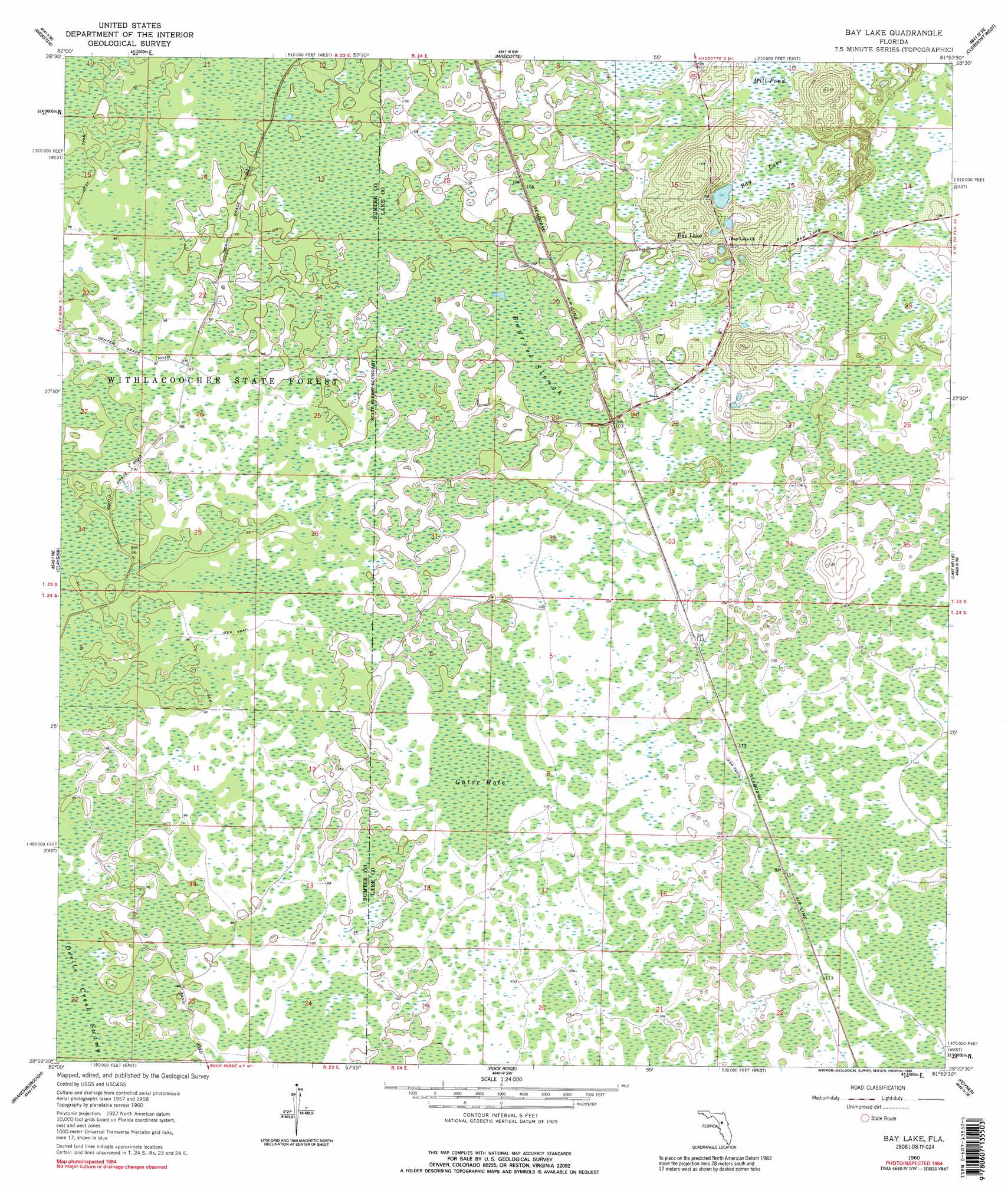
Bay Lake Topo Map Florida
To zoom in, hover over the map of Bay Lake
USGS Topo Quad 28081d8 - 1:24,000 scale
| Topo Map Name: | Bay Lake |
| USGS Topo Quad ID: | 28081d8 |
| Print Size: | ca. 21 1/4" wide x 27" high |
| Southeast Coordinates: | 28.375° N latitude / 81.875° W longitude |
| Map Center Coordinates: | 28.4375° N latitude / 81.9375° W longitude |
| U.S. State: | FL |
| Filename: | O28081D8.jpg |
| Download Map JPG Image: | Bay Lake topo map 1:24,000 scale |
| Map Type: | Topographic |
| Topo Series: | 7.5´ |
| Map Scale: | 1:24,000 |
| Source of Map Images: | United States Geological Survey (USGS) |
| Alternate Map Versions: |
Bay Lake FL 1960, updated 1962 Download PDF Buy paper map Bay Lake FL 1960, updated 1962 Download PDF Buy paper map Bay Lake FL 1960, updated 1989 Download PDF Buy paper map Bay Lake FL 1984, updated 1989 Download PDF Buy paper map Bay Lake FL 2012 Download PDF Buy paper map Bay Lake FL 2015 Download PDF Buy paper map |
1:24,000 Topo Quads surrounding Bay Lake
Wahoo |
Bushnell |
Center Hill |
Hewey In The Hills |
Astatula |
Saint Catherine |
Webster |
Mascotte |
Clermont West |
Clermont East |
Lacoochee |
Clay Sink |
Bay Lake |
Lake Nellie |
Lake Louisa |
Dade City |
Branchborough |
Rock Ridge |
Poyner |
Lake Louisa Sw |
Zephyrhills |
Socrum |
Providence |
Polk City |
Gum Lake |
> Back to 28081a1 at 1:100,000 scale
> Back to 28080a1 at 1:250,000 scale
> Back to U.S. Topo Maps home
Bay Lake topo map: Gazetteer
Bay Lake: Lakes
Mill Pond elevation 31m 101′Bay Lake: Parks
General James A. Van Fleet Trail State Park elevation 31m 101′Bay Lake: Populated Places
Bay Lake elevation 38m 124′Bay Lake: Swamps
Bay Lake elevation 31m 101′Bayroot Slough elevation 30m 98′
Bayroot Slough elevation 30m 98′
Gator Hole elevation 31m 101′
Bay Lake digital topo map on disk
Buy this Bay Lake topo map showing relief, roads, GPS coordinates and other geographical features, as a high-resolution digital map file on DVD: