Bithlo Topo Map Florida
To zoom in, hover over the map of Bithlo
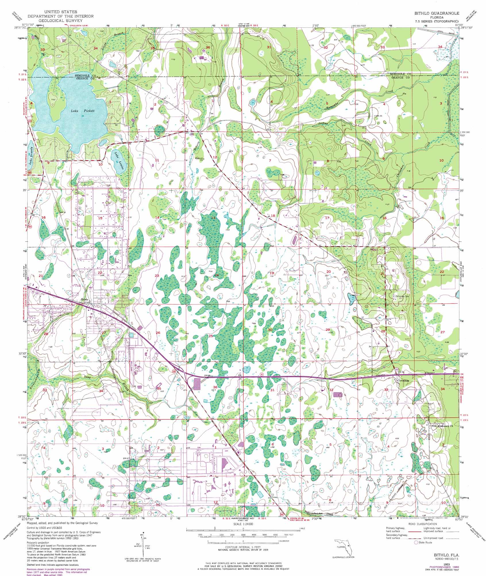
USGS Topo Quad 28081e1 - 1:24,000 scale
| Topo Map Name: | Bithlo |
| USGS Topo Quad ID: | 28081e1 |
| Print Size: | ca. 21 1/4" wide x 27" high |
| Southeast Coordinates: | 28.5° N latitude / 81° W longitude |
| Map Center Coordinates: | 28.5625° N latitude / 81.0625° W longitude |
| U.S. State: | FL |
| Filename: | O28081E1.jpg |
| Download Map JPG Image: | Bithlo topo map 1:24,000 scale |
| Map Type: | Topographic |
| Topo Series: | 7.5´ |
| Map Scale: | 1:24,000 |
| Source of Map Images: | United States Geological Survey (USGS) |
| Alternate Map Versions: |
Bithlo FL 1953, updated 1955 Download PDF Buy paper map Bithlo FL 1953, updated 1963 Download PDF Buy paper map Bithlo FL 1953, updated 1972 Download PDF Buy paper map Bithlo FL 1953, updated 1975 Download PDF Buy paper map Bithlo FL 1953, updated 1981 Download PDF Buy paper map Bithlo FL 2012 Download PDF Buy paper map Bithlo FL 2015 Download PDF Buy paper map |
1:24,000 Topo Quads surrounding Bithlo
Sanford |
Osteen |
Osceola |
Maytown |
Oak Hill |
Casselberry |
Oviedo |
Geneva |
Aurantia |
Mims |
Orlando East |
Oviedo Sw |
Bithlo |
Titusville Sw |
Titusville |
Pine Castle |
Narcoossee Nw |
Narcoossee Ne |
Lake Poinsett Nw |
Sharpes |
Saint Cloud North |
Narcoossee |
Narcoossee Se |
Lake Poinsett Sw |
Lake Poinsett |
> Back to 28081e1 at 1:100,000 scale
> Back to 28080a1 at 1:250,000 scale
> Back to U.S. Topo Maps home
Bithlo topo map: Gazetteer
Bithlo: Lakes
Lake Drawdy elevation 17m 55′Lake Louise elevation 19m 62′
Lake Pickett elevation 16m 52′
Bithlo: Parks
Christmas Park elevation 14m 45′Bithlo: Populated Places
Big T Mobile Home Park elevation 18m 59′Bithlo elevation 19m 62′
Cedarhurst Mobile Home Park elevation 20m 65′
Christmas elevation 13m 42′
Deharts Trailer Park elevation 16m 52′
Holiday Acres Mobile Home Park elevation 18m 59′
J and C Mobile Home Park elevation 19m 62′
Lake Pickett elevation 22m 72′
West Trailer Park Mobile Home Park elevation 21m 68′
Wilsons Trailer Park elevation 15m 49′
Bithlo: Post Offices
Christmas Post Office elevation 14m 45′Bithlo: Streams
Joshua Creek elevation 3m 9′Long Branch elevation 11m 36′
Bithlo digital topo map on disk
Buy this Bithlo topo map showing relief, roads, GPS coordinates and other geographical features, as a high-resolution digital map file on DVD: