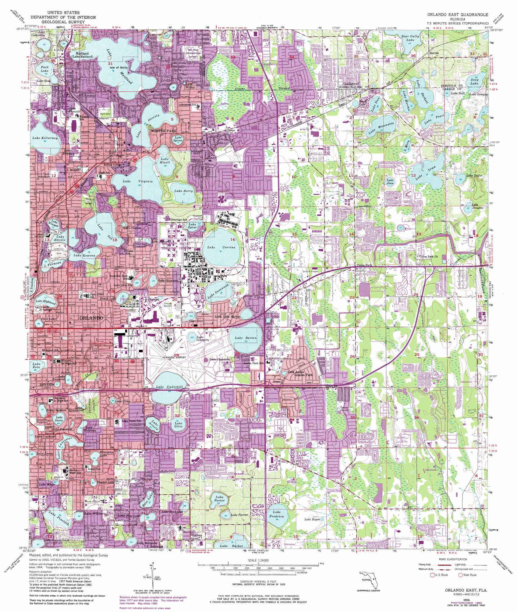
Orlando East Topo Map Florida
To zoom in, hover over the map of Orlando East
USGS Topo Quad 28081e3 - 1:24,000 scale
| Topo Map Name: | Orlando East |
| USGS Topo Quad ID: | 28081e3 |
| Print Size: | ca. 21 1/4" wide x 27" high |
| Southeast Coordinates: | 28.5° N latitude / 81.25° W longitude |
| Map Center Coordinates: | 28.5625° N latitude / 81.3125° W longitude |
| U.S. State: | FL |
| Filename: | O28081E3.jpg |
| Download Map JPG Image: | Orlando East topo map 1:24,000 scale |
| Map Type: | Topographic |
| Topo Series: | 7.5´ |
| Map Scale: | 1:24,000 |
| Source of Map Images: | United States Geological Survey (USGS) |
| Alternate Map Versions: |
Orlando East FL 1956, updated 1957 Download PDF Buy paper map Orlando East FL 1956, updated 1966 Download PDF Buy paper map Orlando East FL 1956, updated 1972 Download PDF Buy paper map Orlando East FL 1956, updated 1981 Download PDF Buy paper map Orlando East FL 1994, updated 2000 Download PDF Buy paper map Orlando East FL 2012 Download PDF Buy paper map Orlando East FL 2015 Download PDF Buy paper map |
1:24,000 Topo Quads surrounding Orlando East
Sorrento |
Sanford Sw |
Sanford |
Osteen |
Osceola |
Apopka |
Forest City |
Casselberry |
Oviedo |
Geneva |
Winter Garden |
Orlando West |
Orlando East |
Oviedo Sw |
Bithlo |
Windermere |
Lake Jessamine |
Pine Castle |
Narcoossee Nw |
Narcoossee Ne |
Intercession City |
Kissimmee |
Saint Cloud North |
Narcoossee |
Narcoossee Se |
> Back to 28081e1 at 1:100,000 scale
> Back to 28080a1 at 1:250,000 scale
> Back to U.S. Topo Maps home
Orlando East topo map: Gazetteer
Orlando East: Airports
Executive Airport elevation 32m 104′Florida Hospital East Orlando Heliport elevation 27m 88′
Florida Hospital Heliport elevation 24m 78′
Naval Hospital Orlando Heliport elevation 32m 104′
Orlando East: Islands
Isle of Sicily elevation 21m 68′Orlando East: Lakes
Bass Lake elevation 27m 88′Bear Gully Lake elevation 14m 45′
Crystal Lake elevation 26m 85′
Deep Lake elevation 17m 55′
Druid Lake elevation 29m 95′
Hourglass Lake elevation 24m 78′
Lake Arnold elevation 28m 91′
Lake Azalea elevation 29m 95′
Lake Baldwin elevation 28m 91′
Lake Barber elevation 27m 88′
Lake Barton elevation 28m 91′
Lake Berry elevation 22m 72′
Lake Burkett elevation 16m 52′
Lake Catherine elevation 20m 65′
Lake Cay Dee elevation 33m 108′
Lake Chelton elevation 25m 82′
Lake Cherokee elevation 23m 75′
Lake Claudette elevation 33m 108′
Lake Como elevation 28m 91′
Lake Copeland elevation 23m 75′
Lake Corrine elevation 28m 91′
Lake Davis elevation 20m 65′
Lake Douglas elevation 20m 65′
Lake Emerald elevation 20m 65′
Lake Eola elevation 26m 85′
Lake Estelle elevation 24m 78′
Lake Farrar elevation 28m 91′
Lake Formosa elevation 22m 72′
Lake Francis elevation 27m 88′
Lake Fredrica elevation 30m 98′
Lake Gear elevation 32m 104′
Lake Gem elevation 22m 72′
Lake Georgette elevation 33m 108′
Lake Giles elevation 30m 98′
Lake Greenwood elevation 18m 59′
Lake Hall elevation 18m 59′
Lake Highland elevation 23m 75′
Lake Howard elevation 31m 101′
Lake Irma elevation 18m 59′
Lake Jean elevation 19m 62′
Lake Knowles elevation 23m 75′
Lake Lancaster elevation 22m 72′
Lake Lawsona elevation 22m 72′
Lake Lily elevation 21m 68′
Lake Lurna elevation 26m 85′
Lake Maitland elevation 20m 65′
Lake Margaret elevation 25m 82′
Lake Marlon elevation 30m 98′
Lake Martha elevation 16m 52′
Lake Mendsen elevation 25m 82′
Lake Midget elevation 27m 88′
Lake Mira elevation 19m 62′
Lake Mizell elevation 21m 68′
Lake Nan elevation 21m 68′
Lake Olive elevation 22m 72′
Lake Osceola elevation 20m 65′
Lake Overstreet elevation 32m 104′
Lake Pearl elevation 16m 52′
Lake Pinelock elevation 28m 91′
Lake Porter elevation 28m 91′
Lake Roper elevation 29m 95′
Lake Rowena elevation 22m 72′
Lake Shannon elevation 33m 108′
Lake Spier elevation 28m 91′
Lake Sue elevation 22m 72′
Lake Susannah elevation 30m 98′
Lake Sylvan elevation 21m 68′
Lake Telfer elevation 19m 62′
Lake Tennessee elevation 26m 85′
Lake Theresa elevation 35m 114′
Lake Underhill elevation 30m 98′
Lake Virginia elevation 20m 65′
Lake Wade elevation 27m 88′
Lake Waunatta elevation 19m 62′
Lake Weldona elevation 22m 72′
Lake Wilbar elevation 27m 88′
Lake Willisara elevation 28m 91′
Lake Winyah elevation 21m 68′
Lake Yvonne elevation 32m 104′
Little Bass Lake elevation 26m 85′
Little Lake Barton elevation 28m 91′
Mud Lake elevation 20m 65′
Park Lake elevation 26m 85′
Park Lake elevation 22m 72′
Perch Lake elevation 23m 75′
Orlando East: Parks
Alfond Swimming Pool elevation 22m 72′Barker Stadium elevation 27m 88′
Cahall Sandspur Field elevation 27m 88′
Cherry Tree Park elevation 32m 104′
Col Joe Kittinger Park elevation 30m 98′
Copland Tennis Stadium elevation 26m 85′
Delaney Street Playground elevation 24m 78′
Demetree Park elevation 33m 108′
Dickson Azalea Park elevation 31m 101′
Duckworth Park elevation 24m 78′
Eddie Graham Sports Stadium elevation 17m 55′
El Dorado Park elevation 32m 104′
Englewood Park elevation 29m 95′
Festival Park elevation 31m 101′
Harry P Leu Gardens elevation 31m 101′
La Costa Wetlands elevation 30m 98′
Lake Como Park elevation 31m 101′
Lake Eola Park elevation 27m 88′
Lake Underhill Park elevation 29m 95′
Lakemont Park elevation 27m 88′
Lockhaven Park elevation 27m 88′
Mayor Carl Langford Park elevation 23m 75′
Mead Garden elevation 26m 85′
Mitchell L Nutter Park elevation 35m 114′
Pflug Hall elevation 26m 85′
The Nature Park elevation 32m 104′
Virginia S Nelson Rose Garden elevation 27m 88′
Wadeview Park elevation 30m 98′
West Underhill Park elevation 32m 104′
Orlando East: Populated Places
Aloma elevation 27m 88′Azalea Park elevation 29m 95′
Balmers Mobile Home Park elevation 20m 65′
Belvins Trailer Park elevation 20m 65′
Bertha elevation 21m 68′
Colonial Village Mobile Home Park elevation 18m 59′
Conway elevation 33m 108′
Goldenrod elevation 26m 85′
Harrell Road Mobile Home Park elevation 19m 62′
Palmer Trailer Park elevation 33m 108′
Shadow Hills Mobile Home Park elevation 23m 75′
Tall Pines Trailer Park elevation 17m 55′
Tamarack East Mobile Home Park elevation 28m 91′
Union Park elevation 25m 82′
Winter Park elevation 28m 91′
Orlando East: Post Offices
Aloma Carrier Annex Post Office elevation 24m 78′Aloma Post Office elevation 27m 88′
Aloma Post Office elevation 27m 88′
Azalea Park Post Office elevation 30m 98′
Colonialtown Post Office elevation 32m 104′
Colonialtown Post Office elevation 32m 104′
Dixie Village Post Office elevation 33m 108′
Herndon Post Office elevation 35m 114′
Union Park Post Office elevation 17m 55′
Ventura Post Office elevation 28m 91′
Winter Park Post Office elevation 28m 91′
Orlando East: Streams
Fern Creek elevation 17m 55′Orlando East: Swamps
Crane Strand elevation 26m 85′Greenwood Urban Wetlands elevation 20m 65′
Orlando East digital topo map on disk
Buy this Orlando East topo map showing relief, roads, GPS coordinates and other geographical features, as a high-resolution digital map file on DVD: