Mascotte Topo Map Florida
To zoom in, hover over the map of Mascotte
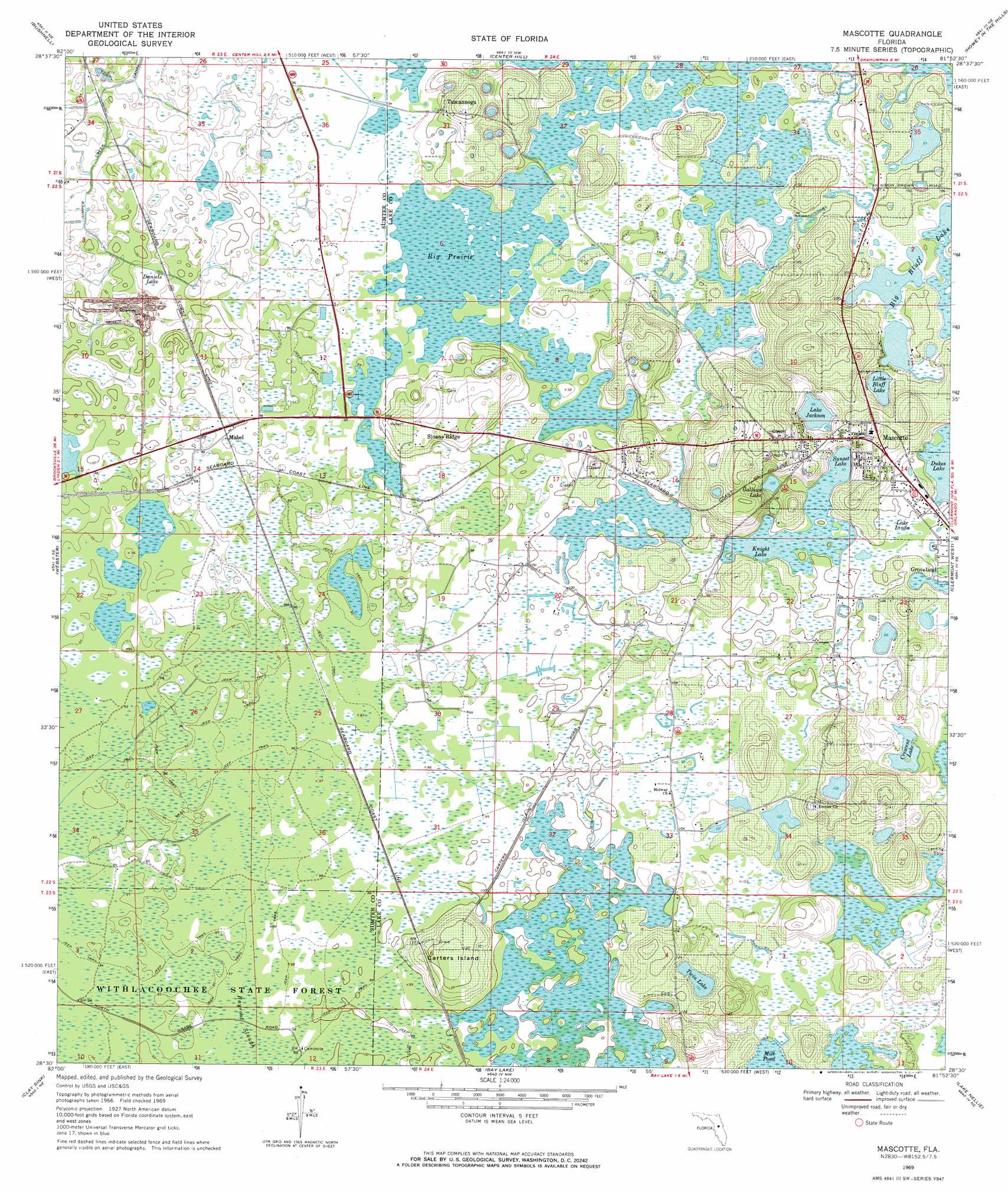
USGS Topo Quad 28081e8 - 1:24,000 scale
| Topo Map Name: | Mascotte |
| USGS Topo Quad ID: | 28081e8 |
| Print Size: | ca. 21 1/4" wide x 27" high |
| Southeast Coordinates: | 28.5° N latitude / 81.875° W longitude |
| Map Center Coordinates: | 28.5625° N latitude / 81.9375° W longitude |
| U.S. State: | FL |
| Filename: | O28081E8.jpg |
| Download Map JPG Image: | Mascotte topo map 1:24,000 scale |
| Map Type: | Topographic |
| Topo Series: | 7.5´ |
| Map Scale: | 1:24,000 |
| Source of Map Images: | United States Geological Survey (USGS) |
| Alternate Map Versions: |
Mascotte FL 1969, updated 1971 Download PDF Buy paper map Mascotte FL 2012 Download PDF Buy paper map Mascotte FL 2015 Download PDF Buy paper map |
1:24,000 Topo Quads surrounding Mascotte
Rutland |
Wildwood |
Leesburg West |
Leesburg East |
Eustis |
Wahoo |
Bushnell |
Center Hill |
Hewey In The Hills |
Astatula |
Saint Catherine |
Webster |
Mascotte |
Clermont West |
Clermont East |
Lacoochee |
Clay Sink |
Bay Lake |
Lake Nellie |
Lake Louisa |
Dade City |
Branchborough |
Rock Ridge |
Poyner |
Lake Louisa Sw |
> Back to 28081e1 at 1:100,000 scale
> Back to 28080a1 at 1:250,000 scale
> Back to U.S. Topo Maps home
Mascotte topo map: Gazetteer
Mascotte: Flats
Big Prairie elevation 28m 91′Mascotte: Islands
Carters Island elevation 40m 131′Mascotte: Lakes
Big Bluff Lake elevation 28m 91′Crescent Lake elevation 31m 101′
Gallows Lake elevation 33m 108′
Knight Lake elevation 29m 95′
Lake Jackson elevation 29m 95′
Lake Linda elevation 30m 98′
Little Bluff Lake elevation 29m 95′
Sunset Lake elevation 29m 95′
Twin Lake elevation 31m 101′
Mascotte: Populated Places
Mabel elevation 31m 101′Mascotte elevation 41m 134′
Mascotte Mobile Home Park elevation 40m 131′
Slones Ridge elevation 32m 104′
Tuscannoga elevation 32m 104′
Mascotte: Post Offices
Mascotte Post Office elevation 37m 121′Mascotte: Ridges
Slones Ridge elevation 36m 118′Mascotte: Swamps
Daniels Lake elevation 26m 85′Mascotte digital topo map on disk
Buy this Mascotte topo map showing relief, roads, GPS coordinates and other geographical features, as a high-resolution digital map file on DVD: