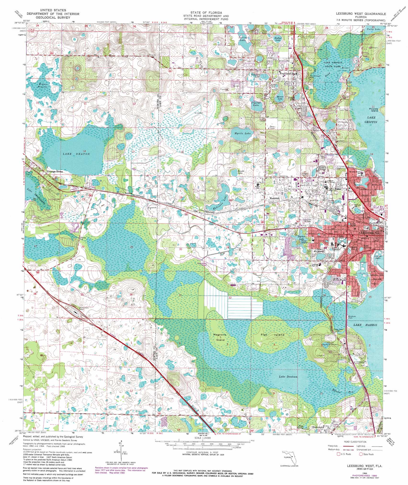
Leesburg West Topo Map Florida
To zoom in, hover over the map of Leesburg West
USGS Topo Quad 28081g8 - 1:24,000 scale
| Topo Map Name: | Leesburg West |
| USGS Topo Quad ID: | 28081g8 |
| Print Size: | ca. 21 1/4" wide x 27" high |
| Southeast Coordinates: | 28.75° N latitude / 81.875° W longitude |
| Map Center Coordinates: | 28.8125° N latitude / 81.9375° W longitude |
| U.S. State: | FL |
| Filename: | O28081G8.jpg |
| Download Map JPG Image: | Leesburg West topo map 1:24,000 scale |
| Map Type: | Topographic |
| Topo Series: | 7.5´ |
| Map Scale: | 1:24,000 |
| Source of Map Images: | United States Geological Survey (USGS) |
| Alternate Map Versions: |
Leesburg West FL 1966 Download PDF Buy paper map Leesburg West FL 1966, updated 1967 Download PDF Buy paper map Leesburg West FL 1966, updated 1968 Download PDF Buy paper map Leesburg West FL 1966, updated 1981 Download PDF Buy paper map Leesburg West FL 1966, updated 1988 Download PDF Buy paper map Leesburg West FL 2012 Download PDF Buy paper map Leesburg West FL 2015 Download PDF Buy paper map |
1:24,000 Topo Quads surrounding Leesburg West
Shady |
Belleview |
Lake Weir |
Lake Mary |
Farles Lake |
Lake Panasoffkee Nw |
Oxford |
Lady Lake |
Emeralda Island |
Umatilla |
Rutland |
Wildwood |
Leesburg West |
Leesburg East |
Eustis |
Wahoo |
Bushnell |
Center Hill |
Hewey In The Hills |
Astatula |
Saint Catherine |
Webster |
Mascotte |
Clermont West |
Clermont East |
> Back to 28081e1 at 1:100,000 scale
> Back to 28080a1 at 1:250,000 scale
> Back to U.S. Topo Maps home
Leesburg West topo map: Gazetteer
Leesburg West: Airports
Flying Baron Estates Airport elevation 19m 62′Leesburg West: Bays
Dead River elevation 17m 55′Leesburg West: Islands
Flat Island elevation 21m 68′Magnolia Island elevation 20m 65′
Stoer Island elevation 26m 85′
Leesburg West: Lakes
Brooks Lake elevation 23m 75′Crystal Lake elevation 23m 75′
Dream Lake elevation 22m 72′
Dyches Lake elevation 23m 75′
Evans Prairie elevation 18m 59′
Fountain Lake elevation 21m 68′
Fountain Lake elevation 26m 85′
Lake Clara elevation 23m 75′
Lake Deaton elevation 19m 62′
Lake Denham elevation 19m 62′
Lake Dixie elevation 23m 75′
Lake Gem elevation 27m 88′
Lake Hollywood elevation 22m 72′
Lake Lucerne elevation 22m 72′
Lake Park elevation 21m 68′
Lake Robin Hood elevation 25m 82′
Mirror Lake elevation 24m 78′
Myrtle Lake elevation 22m 72′
Robinson Lake elevation 22m 72′
Spring Lake elevation 22m 72′
Twin Lake elevation 31m 101′
Zephyr Lake elevation 32m 104′
Leesburg West: Parks
Bonaire Park elevation 22m 72′Lake Griffin State Park elevation 17m 55′
Leesburg High School Stadium elevation 22m 72′
Singletary Park elevation 19m 62′
Venetian Garden elevation 19m 62′
Leesburg West: Populated Places
Bamboo elevation 22m 72′Coachwood Colony Mobile Home Park elevation 27m 88′
Corley Island Mobile Manor elevation 25m 82′
Country Life I Mobile Home Park elevation 31m 101′
Cypress Creek Mobile Home Park elevation 23m 75′
Fruitland Park elevation 33m 108′
Griffwood Mobile Home Park elevation 31m 101′
Harbor Oaks Mobile Home Park Community elevation 21m 68′
Hideaway Mobile Home Park elevation 21m 68′
Lake Griffin Isles Mobile Home Park elevation 22m 72′
Lake Harris Landing Mobile Home Park elevation 28m 91′
Lakeside Mobile Home Court elevation 20m 65′
Lakeside Terrace Mobile Home Park elevation 30m 98′
Lakewood Mobile Home Park elevation 23m 75′
Leesburg elevation 29m 95′
Leesburg Lakeshore Mobile Home Park elevation 23m 75′
Leesburg Landing Mobile Home Park elevation 22m 72′
Montclair elevation 26m 85′
Morgans Mobile Home Park elevation 20m 65′
Okahumpka (historical) elevation 19m 62′
Orange Home elevation 20m 65′
Palm Ridge Mobile Village elevation 20m 65′
Picciola Landing Mobile Home Park elevation 21m 68′
Rail's End Mobile Home Park elevation 25m 82′
Whitney elevation 24m 78′
Leesburg West: Post Offices
Fruitland Park Post Office elevation 36m 118′Leesburg Post Office elevation 21m 68′
Leesburg West: Springs
Bugg Spring elevation 20m 65′Leesburg West: Streams
Helena Run elevation 19m 62′Leesburg West: Summits
Trinity Learning Center elevation 38m 124′Leesburg West: Swamps
Okahumpka Swamp elevation 19m 62′Leesburg West digital topo map on disk
Buy this Leesburg West topo map showing relief, roads, GPS coordinates and other geographical features, as a high-resolution digital map file on DVD: