Pine Lakes Topo Map Florida
To zoom in, hover over the map of Pine Lakes
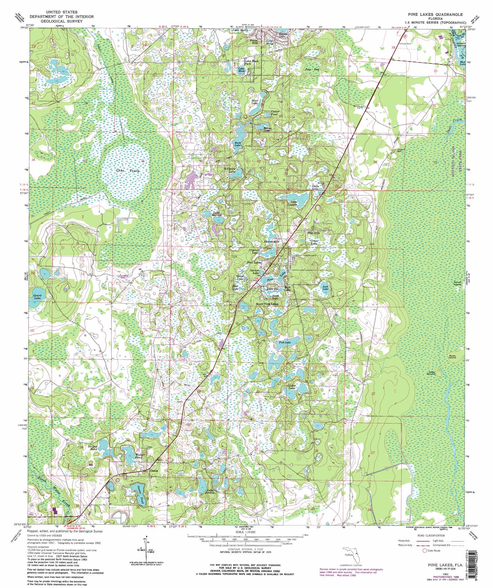
USGS Topo Quad 28081h4 - 1:24,000 scale
| Topo Map Name: | Pine Lakes |
| USGS Topo Quad ID: | 28081h4 |
| Print Size: | ca. 21 1/4" wide x 27" high |
| Southeast Coordinates: | 28.875° N latitude / 81.375° W longitude |
| Map Center Coordinates: | 28.9375° N latitude / 81.4375° W longitude |
| U.S. State: | FL |
| Filename: | O28081H4.jpg |
| Download Map JPG Image: | Pine Lakes topo map 1:24,000 scale |
| Map Type: | Topographic |
| Topo Series: | 7.5´ |
| Map Scale: | 1:24,000 |
| Source of Map Images: | United States Geological Survey (USGS) |
| Alternate Map Versions: |
Pine Lakes FL 1962, updated 1963 Download PDF Buy paper map Pine Lakes FL 1962, updated 1981 Download PDF Buy paper map Pine Lakes FL 1962, updated 1988 Download PDF Buy paper map Pine Lakes FL 1962, updated 1988 Download PDF Buy paper map Pine Lakes FL 2012 Download PDF Buy paper map Pine Lakes FL 2015 Download PDF Buy paper map |
| FStopo: | US Forest Service topo Pine Lakes is available: Download FStopo PDF Download FStopo TIF |
1:24,000 Topo Quads surrounding Pine Lakes
Juniper Springs |
Astor |
Pierson |
Lake Dias |
Daytona Beach Nw |
Farles Lake |
Alexander Springs |
Lake Woodruff |
De Land |
Daytona Beach Sw |
Umatilla |
Paisley |
Pine Lakes |
Orange City |
Lake Helen |
Eustis |
Sorrento |
Sanford Sw |
Sanford |
Osteen |
Astatula |
Apopka |
Forest City |
Casselberry |
Oviedo |
> Back to 28081e1 at 1:100,000 scale
> Back to 28080a1 at 1:250,000 scale
> Back to U.S. Topo Maps home
Pine Lakes topo map: Gazetteer
Pine Lakes: Airports
Bradshaw Farm Airport elevation 16m 52′Britt Brown and Porter Ranch Airport elevation 11m 36′
Pine Lakes Farm Airport elevation 14m 45′
Royal Trails Airport elevation 14m 45′
Pine Lakes: Islands
Bush Island elevation 1m 3′Drigger Islands elevation 1m 3′
Otter Mound elevation 1m 3′
Pine Lakes: Lakes
Bass Lake elevation 11m 36′Bear Lake elevation 14m 45′
Benton Lake elevation 13m 42′
Buck Lake elevation 15m 49′
Cooter Pond elevation 14m 45′
Crystal Lake elevation 12m 39′
Dade Lake elevation 12m 39′
Deer Lake elevation 12m 39′
Fish Lake elevation 11m 36′
Gaiter Lake elevation 12m 39′
Gourd Lake elevation 16m 52′
Grass Lake elevation 12m 39′
Hanna Lake elevation 14m 45′
Hedges Pond elevation 13m 42′
Jack Lake elevation 11m 36′
Lake Dot elevation 11m 36′
Lake Jordan elevation 12m 39′
Lake Lappin elevation 13m 42′
Lake Mack elevation 15m 49′
Lake Marion elevation 13m 42′
Owens Pond elevation 13m 42′
Pine Lake elevation 11m 36′
Saint Claire Lake elevation 15m 49′
South Lake elevation 11m 36′
Spruce Lake elevation 11m 36′
Walker Pond elevation 13m 42′
Pine Lakes: Populated Places
Cassia elevation 21m 68′Florida Hills elevation 15m 49′
Lake Mack Park elevation 17m 55′
Pine Hills elevation 12m 39′
Pine Lakes elevation 15m 49′
South Pine Lakes elevation 17m 55′
Pine Lakes: Swamps
Grass Lake elevation 12m 39′Jake Bay elevation 11m 36′
Lake Holly elevation 15m 49′
Lake Tracy elevation 10m 32′
Pine Lakes digital topo map on disk
Buy this Pine Lakes topo map showing relief, roads, GPS coordinates and other geographical features, as a high-resolution digital map file on DVD: