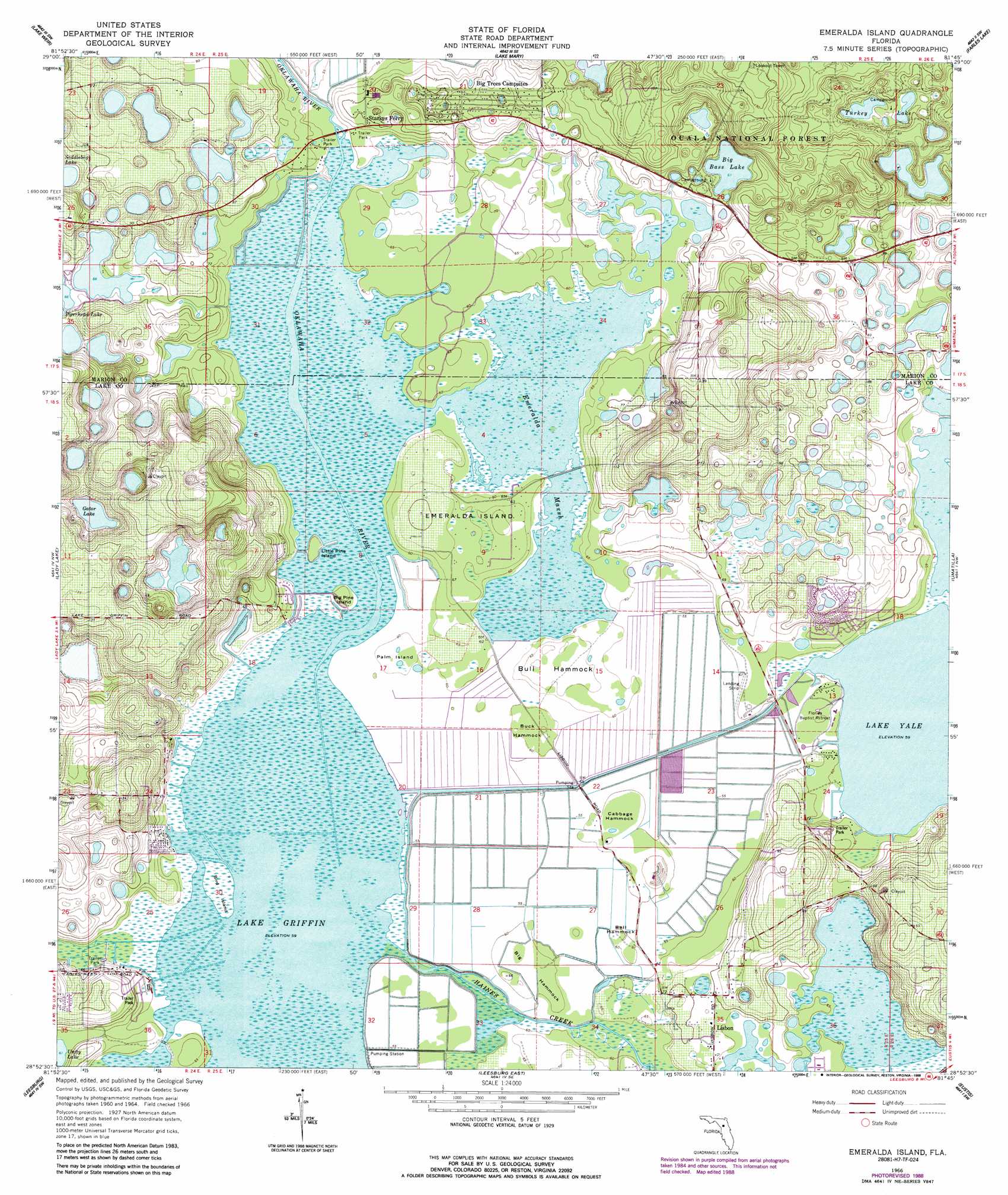
Emeralda Island Topo Map Florida
To zoom in, hover over the map of Emeralda Island
USGS Topo Quad 28081h7 - 1:24,000 scale
| Topo Map Name: | Emeralda Island |
| USGS Topo Quad ID: | 28081h7 |
| Print Size: | ca. 21 1/4" wide x 27" high |
| Southeast Coordinates: | 28.875° N latitude / 81.75° W longitude |
| Map Center Coordinates: | 28.9375° N latitude / 81.8125° W longitude |
| U.S. State: | FL |
| Filename: | O28081H7.jpg |
| Download Map JPG Image: | Emeralda Island topo map 1:24,000 scale |
| Map Type: | Topographic |
| Topo Series: | 7.5´ |
| Map Scale: | 1:24,000 |
| Source of Map Images: | United States Geological Survey (USGS) |
| Alternate Map Versions: |
Emeralda Island FL 1966, updated 1968 Download PDF Buy paper map Emeralda Island FL 1966, updated 1979 Download PDF Buy paper map Emeralda Island FL 1966, updated 1988 Download PDF Buy paper map Emeralda Island FL 2012 Download PDF Buy paper map Emeralda Island FL 2015 Download PDF Buy paper map |
| FStopo: | US Forest Service topo Emeralda Island is available: Download FStopo PDF Download FStopo TIF |
1:24,000 Topo Quads surrounding Emeralda Island
Ocala East |
Lynne |
Halfmoon Lake |
Juniper Springs |
Astor |
Belleview |
Lake Weir |
Lake Mary |
Farles Lake |
Alexander Springs |
Oxford |
Lady Lake |
Emeralda Island |
Umatilla |
Paisley |
Wildwood |
Leesburg West |
Leesburg East |
Eustis |
Sorrento |
Bushnell |
Center Hill |
Hewey In The Hills |
Astatula |
Apopka |
> Back to 28081e1 at 1:100,000 scale
> Back to 28080a1 at 1:250,000 scale
> Back to U.S. Topo Maps home
Emeralda Island topo map: Gazetteer
Emeralda Island: Airports
Eustis Muck Farms Incorporated Airport (historical) elevation 18m 59′Flying Exotics Airport (historical) elevation 47m 154′
Fly'n R Ranch Airport elevation 19m 62′
Emeralda Island: Islands
Bell Hammock elevation 18m 59′Big Hammock elevation 18m 59′
Big Pine Island elevation 18m 59′
Bird Island elevation 18m 59′
Buck Hammock elevation 19m 62′
Bull Hammock elevation 20m 65′
Cabbage Hammock elevation 19m 62′
Emeralda Island elevation 20m 65′
Little Pine Island elevation 18m 59′
Palm Island elevation 18m 59′
Emeralda Island: Lakes
Big Bass Lake elevation 18m 59′Gator Lake elevation 20m 65′
Island Ponds elevation 19m 62′
Turkey Lake elevation 19m 62′
Emeralda Island: Populated Places
Fishermans Wharf Mobile Home Park elevation 17m 55′Linadale elevation 28m 91′
Sandpiper Mobile Home Manor elevation 22m 72′
Starkes Ferry elevation 21m 68′
Sunlake Estates Mobile Park elevation 24m 78′
Emeralda Island: Swamps
Emeralda Marsh elevation 18m 59′Emeralda Island digital topo map on disk
Buy this Emeralda Island topo map showing relief, roads, GPS coordinates and other geographical features, as a high-resolution digital map file on DVD: