Citrus Park Topo Map Florida
To zoom in, hover over the map of Citrus Park
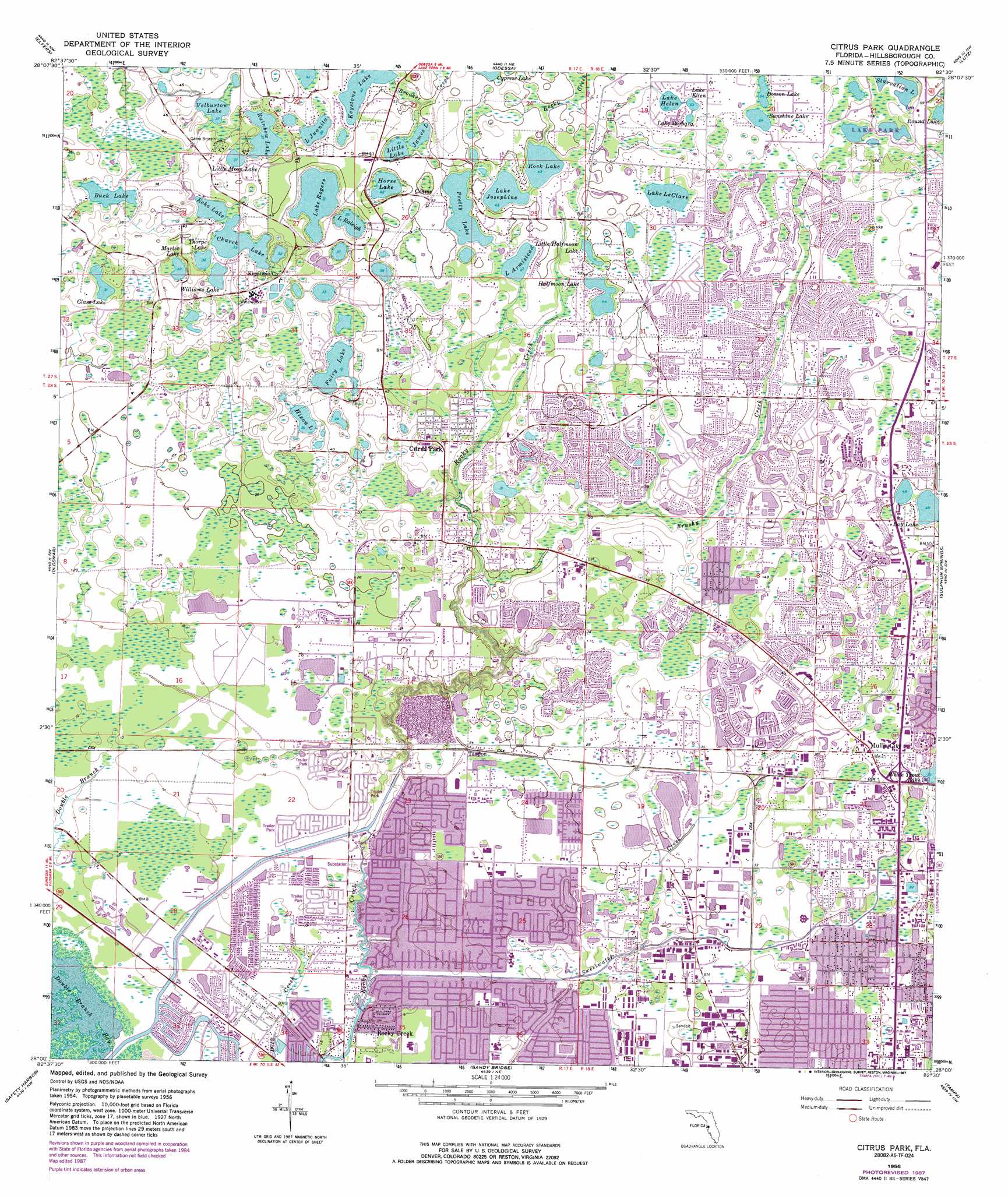
USGS Topo Quad 28082a5 - 1:24,000 scale
| Topo Map Name: | Citrus Park |
| USGS Topo Quad ID: | 28082a5 |
| Print Size: | ca. 21 1/4" wide x 27" high |
| Southeast Coordinates: | 28° N latitude / 82.5° W longitude |
| Map Center Coordinates: | 28.0625° N latitude / 82.5625° W longitude |
| U.S. State: | FL |
| Filename: | O28082A5.jpg |
| Download Map JPG Image: | Citrus Park topo map 1:24,000 scale |
| Map Type: | Topographic |
| Topo Series: | 7.5´ |
| Map Scale: | 1:24,000 |
| Source of Map Images: | United States Geological Survey (USGS) |
| Alternate Map Versions: |
Citrus Park FL 1947 Download PDF Buy paper map Citrus Park FL 1956, updated 1957 Download PDF Buy paper map Citrus Park FL 1956, updated 1969 Download PDF Buy paper map Citrus Park FL 1956, updated 1970 Download PDF Buy paper map Citrus Park FL 1956, updated 1987 Download PDF Buy paper map Citrus Park FL 1998, updated 2001 Download PDF Buy paper map Citrus Park FL 2012 Download PDF Buy paper map Citrus Park FL 2015 Download PDF Buy paper map |
1:24,000 Topo Quads surrounding Citrus Park
Port Richey |
Fivay Junction |
Ehren |
San Antonio |
|
Tarpon Springs |
Elfers |
Odessa |
Lutz |
Wesley Chapel |
Dunedin |
Oldsmar |
Citrus Park |
Sulphur Springs |
Thonotosassa |
Clearwater |
Safety Harbor |
Gandy Bridge |
Tampa |
Brandon |
Seminole |
Saint Petersburg |
Port Tampa |
Gibsonton |
Riverview |
> Back to 28082a1 at 1:100,000 scale
> Back to 28082a1 at 1:250,000 scale
> Back to U.S. Topo Maps home
Citrus Park topo map: Gazetteer
Citrus Park: Airports
Broady Airport elevation 9m 29′Citrus Park: Bays
Double Branch Bay elevation 0m 0′Citrus Park: Lakes
Bay Lake elevation 13m 42′Buck Lake elevation 10m 32′
Church Lake elevation 10m 32′
Dosson Lake elevation 16m 52′
Echo Lake elevation 10m 32′
Equus Meadow Pond elevation 3m 9′
Fairy Lake elevation 10m 32′
Glass Lake elevation 10m 32′
Halfmoon Lake elevation 13m 42′
Hixon Lake elevation 10m 32′
Horse Lake elevation 13m 42′
James Lake elevation 13m 42′
Lake Armistead elevation 13m 42′
Lake Barbara elevation 16m 52′
Lake Ellen elevation 16m 52′
Lake Helen elevation 16m 52′
Lake Josephine elevation 13m 42′
Lake Juanita elevation 12m 39′
Lake LeClare elevation 16m 52′
Lake Raleigh elevation 11m 36′
Lake Rogers elevation 12m 39′
Little Halfmoon Lake elevation 14m 45′
Little Lake elevation 13m 42′
Little Moon Lake elevation 11m 36′
Marlee Lake elevation 10m 32′
Pretty Lake elevation 13m 42′
Rainbow Lake elevation 11m 36′
Rock Lake elevation 13m 42′
Round Lake elevation 16m 52′
Starvation Lake elevation 14m 45′
Sunshine Lake elevation 16m 52′
Thorpe Lake elevation 10m 32′
Velburton Lake elevation 11m 36′
Williams Lake elevation 10m 32′
Citrus Park: Populated Places
Americana elevation 6m 19′Andover elevation 11m 36′
Andover Village elevation 10m 32′
Ansley Park elevation 10m 32′
Arbor Lakes elevation 11m 36′
Arbor Oaks elevation 12m 39′
Arbor Ridge elevation 12m 39′
Arlington elevation 17m 55′
Arlington Oaks elevation 17m 55′
Armistead Manor elevation 13m 42′
Arthur Estates elevation 9m 29′
Avery Oaks elevation 7m 22′
Bay Lake elevation 15m 49′
Bayport West elevation 2m 6′
Beacon Meadows elevation 13m 42′
Bellamy elevation 13m 42′
Belle Glen elevation 15m 49′
Belle Glen Addition elevation 16m 52′
Belle Meade elevation 15m 49′
Bellefield Village elevation 11m 36′
Bellingham Oaks elevation 4m 13′
Bent Tree Place elevation 13m 42′
Berkeley Square elevation 3m 9′
Berkford Place elevation 14m 45′
Bradford elevation 15m 49′
Brentwood elevation 17m 55′
Brentwood Park elevation 16m 52′
Brightside Village elevation 11m 36′
Brookgreen Village elevation 13m 42′
Brookshire elevation 14m 45′
Burnbrook elevation 12m 39′
Byars Heights elevation 1m 3′
Cambridge Villas elevation 9m 29′
Cameo Villas elevation 7m 22′
Canterbury elevation 17m 55′
Carrillon Estates elevation 14m 45′
Carroll Oaks elevation 10m 32′
Carrollwood Cove elevation 14m 45′
Carrollwood Creek elevation 11m 36′
Carrollwood Crossing elevation 13m 42′
Carrollwood Estates elevation 13m 42′
Carrollwood Key elevation 10m 32′
Carrollwood Meadows elevation 13m 42′
Carrollwood Oaks elevation 11m 36′
Carrollwood Pines elevation 12m 39′
Carrollwood Preserve elevation 12m 39′
Carrollwood Reserve elevation 11m 36′
Carrollwood South elevation 12m 39′
Carrollwood Springs elevation 15m 49′
Carrollwood Village elevation 14m 45′
Carrollwood West elevation 13m 42′
Casa Blanca elevation 6m 19′
Casey Lake Manors elevation 14m 45′
Caseys Landing elevation 13m 42′
Catherine Park elevation 17m 55′
Cedar Creek at Country Run elevation 10m 32′
Cedarwood Village elevation 10m 32′
Chadbourne Village elevation 10m 32′
Citrus Acres elevation 14m 45′
Citrus Green elevation 12m 39′
Citrus Park elevation 13m 42′
Citrus Park Commons elevation 11m 36′
Citrus Park Crossing elevation 10m 32′
Citrus Pointe elevation 13m 42′
Community Estates elevation 12m 39′
Cone Estates elevation 15m 49′
Copperfield elevation 7m 22′
Cosme elevation 15m 49′
Country Club Village at Carrollwood elevation 16m 52′
Country Place elevation 15m 49′
Country Place West elevation 16m 52′
Country Run elevation 11m 36′
Country Village elevation 15m 49′
Creekside elevation 11m 36′
Crestridge elevation 3m 9′
Culbreath Oaks elevation 14m 45′
Cumberland Estates elevation 13m 42′
Cumberland Manors elevation 13m 42′
Cypress Glen elevation 11m 36′
Cypress Hollow elevation 13m 42′
Cypress Meadows elevation 18m 59′
Cypress Run elevation 17m 55′
Cypress Trace elevation 15m 49′
Cypress Tree elevation 6m 19′
Cypress Willows elevation 10m 32′
Devonshire Woods elevation 14m 45′
Dolce Vita elevation 16m 52′
Durango elevation 10m 32′
Eagle Creek elevation 9m 29′
Eaglebrook elevation 12m 39′
East Village elevation 14m 45′
Eastbrook elevation 14m 45′
Echo Lake Estates elevation 14m 45′
Edgewater Place elevation 5m 16′
Edna Court elevation 12m 39′
Ehrlich Gardenlands elevation 15m 49′
Enclave at Citrus Park elevation 7m 22′
Enclave of Carrollwood elevation 12m 39′
Essex Downs elevation 1m 3′
Estates of Rock Lake elevation 15m 49′
Fairfield Village elevation 11m 36′
Fairway Village elevation 15m 49′
Farmington elevation 13m 42′
Fawn Lake elevation 10m 32′
Fawn Ridge Village elevation 7m 22′
Floraland Acres elevation 14m 45′
Fountain Park elevation 3m 9′
Four Score Manor elevation 17m 55′
Foxs Corner elevation 16m 52′
Frenchs elevation 15m 49′
Galleria elevation 12m 39′
George Road Estates elevation 4m 13′
Glen Ellen Village elevation 13m 42′
Green Grass Acres elevation 8m 26′
Greenbrook Village elevation 11m 36′
Grove Point Village elevation 13m 42′
Half Moon Lake Estates elevation 15m 49′
Half Moon Tracts elevation 13m 42′
Hamilton Park elevation 3m 9′
Hammock Woods elevation 14m 45′
Hampton Park elevation 12m 39′
Harr Estates elevation 16m 52′
Heatherwood Village elevation 15m 49′
Hibiscus Gardens elevation 10m 32′
Hidden Lake elevation 13m 42′
Hidden Oaks elevation 11m 36′
Hidden Valley elevation 12m 39′
Highland Park elevation 8m 26′
Hilltop Acres elevation 16m 52′
Himes Avenue Estates elevation 12m 39′
Hollyglen Village elevation 13m 42′
Horseshoe Estates elevation 11m 36′
Hudson Terrace elevation 12m 39′
Hunters Glen elevation 15m 49′
Huntington of Carrollwood elevation 10m 32′
Idle Forest elevation 10m 32′
Indian Lakes elevation 11m 36′
Indian Oaks elevation 10m 32′
Jane Terrace elevation 2m 6′
Jasmine Pond elevation 10m 32′
J-R Manor elevation 7m 22′
Kanter-Baker Estates elevation 16m 52′
Keystone Acres elevation 14m 45′
Keystone Crossings elevation 11m 36′
Keystone Groves elevation 16m 52′
Keystone Meadow I elevation 16m 52′
Keystone Shores Estates elevation 16m 52′
Kirby Creek elevation 9m 29′
Kirkland Acres elevation 17m 55′
Koostra elevation 12m 39′
Lake Crest Manor elevation 1m 3′
Lake Josephine Estates elevation 14m 45′
Lake Julia elevation 12m 39′
Lake Leta Trace elevation 16m 52′
Lake Maurine elevation 12m 39′
Lake Maurine Estates elevation 11m 36′
Lake View Park elevation 12m 39′
Lakeshore elevation 17m 55′
Lakeside Grove Estates elevation 12m 39′
Lakeside Point elevation 15m 49′
Lane Farms elevation 3m 9′
Le Clare Estates elevation 17m 55′
Le Clare Shores elevation 18m 59′
Leto elevation 9m 29′
Levinson elevation 15m 49′
Logan Gate Village elevation 11m 36′
Logan Place elevation 9m 29′
Longboat Landing elevation 16m 52′
Lowell Village elevation 13m 42′
Lynn Lake elevation 11m 36′
Mandarin Lakes elevation 14m 45′
Mandolin elevation 6m 19′
Manhattan Park elevation 11m 36′
Martha Ann Trailer Village elevation 14m 45′
Meadow Brook elevation 4m 13′
Meadowglen elevation 11m 36′
Mecca City elevation 1m 3′
Mid Village elevation 17m 55′
Mill Pond Village elevation 10m 32′
Miralago Estates elevation 17m 55′
Mohr Loop elevation 1m 3′
Monaco Gardens elevation 16m 52′
Morganwoods Garden Homes elevation 3m 9′
Mullins Manor elevation 10m 32′
Mullis City elevation 12m 39′
Native Woods elevation 13m 42′
Newport Landing elevation 10m 32′
North End Terrace elevation 14m 45′
North Village elevation 17m 55′
Northbridge at Lake Pretty elevation 15m 49′
Northdale elevation 18m 59′
Northlake Village elevation 12m 39′
Northrop Terrace elevation 14m 45′
Northton Groves elevation 13m 42′
Northwest Park elevation 4m 13′
Oak Trace elevation 7m 22′
Oak View Terrace elevation 6m 19′
Oakmeadows West elevation 10m 32′
Oakwood Villa elevation 12m 39′
Ocean Harbor elevation 6m 19′
Oldsmar Farm elevation 1m 3′
Orange Blossom Creek elevation 15m 49′
O'Ryans Point on Half Moon Lake elevation 13m 42′
Paddock Trail elevation 14m 45′
Parkwood Village elevation 12m 39′
Pat Acres elevation 3m 9′
Patterson Road elevation 13m 42′
Pebblebrook elevation 4m 13′
Pennington Village elevation 16m 52′
Pine Crest Manor elevation 9m 29′
Pine Hollow elevation 15m 49′
Pine Meadows elevation 12m 39′
Pine Terrace elevation 10m 32′
Pinecrest Villa elevation 9m 29′
Pinehurst Villas elevation 4m 13′
Plouff elevation 1m 3′
Pretty Lake Estates elevation 15m 49′
Quail Ridge elevation 10m 32′
Quail Ridge North elevation 10m 32′
Rainbow Terrace elevation 12m 39′
Rawls Road elevation 13m 42′
Reserve at Woodmont elevation 11m 36′
Reserve on Rock Lake elevation 16m 52′
Rock Lake elevation 13m 42′
Rocky Creek elevation 1m 3′
Rocky Ford elevation 1m 3′
Rocky Pond elevation 14m 45′
Rose Harbor elevation 7m 22′
Rosemount Village elevation 12m 39′
Saint Andrews Square elevation 10m 32′
Saint James elevation 14m 45′
Sandpiper elevation 5m 16′
Shadberry Village elevation 10m 32′
Shaw Place elevation 13m 42′
Shays Crest elevation 13m 42′
Sheldon Chase elevation 4m 13′
Sheldon West Mobile Home Community elevation 7m 22′
Solana Bay elevation 7m 22′
South Lake Shores elevation 13m 42′
Southern Comfort Homes elevation 5m 16′
Southfork at Van Dyke Farms elevation 15m 49′
Spivey elevation 14m 45′
Springwood Village elevation 13m 42′
Stasia elevation 14m 45′
Steeplechase elevation 12m 39′
Stonegate elevation 15m 49′
Stonehedge elevation 14m 45′
Stoneleigh elevation 17m 55′
Sugarwood Grove elevation 13m 42′
Sunray Estates elevation 3m 9′
Sunray Gardens elevation 11m 36′
Sunshine Village elevation 14m 45′
Tarpon elevation 7m 22′
The Cloister elevation 16m 52′
The Lakes at Van Dyke Farms elevation 16m 52′
The Landings of Tampa elevation 10m 32′
The Paddocks at Van Dyke Farms elevation 15m 49′
The Trails at Van Dyke Farms elevation 16m 52′
The Village South elevation 15m 49′
The Village West elevation 15m 49′
Timberlane elevation 3m 9′
Top of the Village elevation 15m 49′
Town 'n' Country elevation 1m 3′
Town of Citrus Park elevation 13m 42′
Town Park elevation 6m 19′
Towne Place elevation 7m 22′
Traditions at Woodmont elevation 10m 32′
Trafalgar Square elevation 10m 32′
Tree Tops North elevation 6m 19′
Treehouses at Mohr Loop elevation 1m 3′
Triple Lake Shores elevation 17m 55′
Triple Lakes elevation 17m 55′
Tropical Gardens elevation 10m 32′
Turner Trace elevation 13m 42′
Turtle Creek elevation 12m 39′
Turtle Crossing elevation 15m 49′
Twelve Oaks Village elevation 4m 13′
Ventana elevation 13m 42′
Villa Largo elevation 10m 32′
Village Estates elevation 16m 52′
Village Wood elevation 13m 42′
Villager Place elevation 10m 32′
Villas of Northdale elevation 15m 49′
Villas of San Marino at Carrollwood elevation 16m 52′
Warren Estates elevation 14m 45′
Waterchase elevation 7m 22′
Waterfront Cove elevation 1m 3′
Waterstone elevation 12m 39′
Wellington Homes at Countryway elevation 2m 6′
West Bay elevation 2m 6′
West Chase elevation 5m 16′
West Park elevation 9m 29′
West Park Estates elevation 8m 26′
West Waters Village elevation 3m 9′
Westmont Oaks elevation 4m 13′
Westridge Village elevation 11m 36′
Whirley Estates elevation 17m 55′
Whisper Sound elevation 16m 52′
Whispering Oaks elevation 11m 36′
White Trout Lake Shores elevation 12m 39′
Wildewood Village elevation 11m 36′
Willowbrae Village elevation 12m 39′
Windsor Place at Citrus Park elevation 6m 19′
Wingate Village elevation 14m 45′
Wood Lake elevation 3m 9′
Woodacre Estates of Northdale elevation 17m 55′
Woodbriar West elevation 12m 39′
Woodbridge at Rocky Creek elevation 1m 3′
Woodbridge Park elevation 4m 13′
Woodham Farms elevation 17m 55′
Woodmont elevation 12m 39′
Woodroffe Estates elevation 12m 39′
Woods of Eden Rock elevation 13m 42′
Yent elevation 13m 42′
Citrus Park: Post Offices
Carrollwood Post Office elevation 14m 45′Ehrlich Post Office elevation 17m 55′
Citrus Park: Reservoirs
Paradise Lake elevation 14m 45′Citrus Park: Streams
Brushy Creek elevation 8m 26′Citrus Park digital topo map on disk
Buy this Citrus Park topo map showing relief, roads, GPS coordinates and other geographical features, as a high-resolution digital map file on DVD: