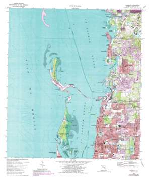
Dunedin Topo Map Florida
To zoom in, hover over the map of Dunedin
USGS Topo Quad 28082a7 - 1:24,000 scale
| Topo Map Name: | Dunedin |
| USGS Topo Quad ID: | 28082a7 |
| Print Size: | ca. 21 1/4" wide x 27" high |
| Southeast Coordinates: | 28° N latitude / 82.75° W longitude |
| Map Center Coordinates: | 28.0625° N latitude / 82.8125° W longitude |
| U.S. State: | FL |
| Filename: | O28082A7.jpg |
| Download Map JPG Image: | Dunedin topo map 1:24,000 scale |
| Map Type: | Topographic |
| Topo Series: | 7.5´ |
| Map Scale: | 1:24,000 |
| Source of Map Images: | United States Geological Survey (USGS) |
| Alternate Map Versions: |
Dunedin FL 1943, updated 1961 Download PDF Buy paper map Dunedin FL 1943, updated 1961 Download PDF Buy paper map Dunedin FL 1974, updated 1977 Download PDF Buy paper map Dunedin FL 1974, updated 1988 Download PDF Buy paper map Dunedin FL 1974, updated 1988 Download PDF Buy paper map Dunedin FL 1998, updated 2001 Download PDF Buy paper map Dunedin FL 2012 Download PDF Buy paper map Dunedin FL 2015 Download PDF Buy paper map |
1:24,000 Topo Quads surrounding Dunedin
Port Richey |
Fivay Junction |
|||
Tarpon Springs |
Elfers |
Odessa |
||
Dunedin |
Oldsmar |
Citrus Park |
||
Clearwater |
Safety Harbor |
Gandy Bridge |
||
Seminole |
Saint Petersburg |
Port Tampa |
> Back to 28082a1 at 1:100,000 scale
> Back to 28082a1 at 1:250,000 scale
> Back to U.S. Topo Maps home
Dunedin topo map: Gazetteer
Dunedin: Airports
Dunedin Heliport elevation 2m 6′Mease Hospital Emergency Heliport elevation 11m 36′
Dunedin: Bars
Three Rooker Bar elevation 0m 0′Dunedin: Bays
Boggy Bayou elevation 0m 0′Greens Bayou elevation 0m 0′
Klosterman Bayou elevation 0m 0′
Little Bayou elevation 0m 0′
Lungrun Cove elevation 0m 0′
Pelican Cove elevation 0m 0′
Saint Joseph Sound elevation 0m 0′
Scharrer Bayou elevation 0m 0′
Smith Bayou elevation 0m 0′
Sutherland Bayou elevation 0m 0′
Dunedin: Beaches
Dunedin Beach elevation 2m 6′Dunedin: Bridges
Bascule Bridge elevation 0m 0′Dunedin: Capes
Burghstream Point elevation 0m 0′Danenman Point elevation 0m 0′
Klosterman Point elevation 0m 0′
Lone Oak Point elevation 0m 0′
Malone Point elevation 0m 0′
Pelican Point elevation 0m 0′
Redfish Point elevation 0m 0′
Seaside Point elevation 1m 3′
Dunedin: Channels
Dunedin Channel elevation 0m 0′Dunedin Pass elevation 0m 0′
Hurricane Pass elevation 0m 0′
Scharrer Cut elevation 0m 0′
Dunedin: Guts
Avery Bayou elevation 0m 0′Brooker Creek elevation 0m 0′
Seven Mouth Creek elevation 0m 0′
Dunedin: Islands
Bird Key elevation 0m 0′Caladesi Island elevation 1m 3′
Core Island elevation 0m 0′
Garden Island elevation 0m 0′
Grassy Key elevation 0m 0′
Honeymoon Island elevation 1m 3′
Indian Bluff Island elevation 1m 3′
Malone Island elevation 0m 0′
Moonshine Island elevation 0m 0′
North Point Hog Island elevation 0m 0′
Sand Keys elevation 0m 0′
Smith Islands elevation 0m 0′
Ward Island elevation 0m 0′
Dunedin: Lakes
Jerry Lake elevation 13m 42′Lake Chautauqua elevation 1m 3′
Lake Sperry elevation 4m 13′
Dunedin: Parks
Amberlea Park elevation 15m 49′Armston Park elevation 3m 9′
Caladesi Island State Park elevation 1m 3′
Crystal Beach Park elevation 1m 3′
Curlew Creek Park elevation 2m 6′
Dunedin Stadium elevation 5m 16′
Dunedin Youth Guild Park elevation 1m 3′
Eagle Scout Park elevation 8m 26′
Edgewater Park elevation 2m 6′
Elizabeth Skinner-Jackson Playground elevation 7m 22′
Grant Field elevation 6m 19′
Hammock Park elevation 1m 3′
Happy Tails Dog Park elevation 17m 55′
Highlander Park elevation 3m 9′
Honeymoon Island State Park elevation 1m 3′
Louis A Vanech Recreation Complex elevation 17m 55′
Scotsdale Park elevation 12m 39′
Dunedin: Populated Places
Acklocknayke (historical) elevation 0m 0′Cove Springs elevation 1m 3′
Crystal Beach elevation 4m 13′
Dunedin elevation 9m 29′
Dunedin Isles elevation 1m 3′
Harbor View elevation 1m 3′
Innisbrook elevation 5m 16′
Ozona elevation 3m 9′
Palm Harbor elevation 15m 49′
Wall Springs elevation 1m 3′
Dunedin: Post Offices
Dunedin Post Office elevation 16m 52′Dunedin: Springs
Sage Spring elevation 0m 0′Dunedin: Streams
Cedar Creek elevation 0m 0′Curlew Creek elevation 0m 0′
Jerry Branch elevation 4m 13′
Dunedin: Swamps
Ogden Bayou elevation 1m 3′Dunedin digital topo map on disk
Buy this Dunedin topo map showing relief, roads, GPS coordinates and other geographical features, as a high-resolution digital map file on DVD:


