San Antonio Topo Map Florida
To zoom in, hover over the map of San Antonio
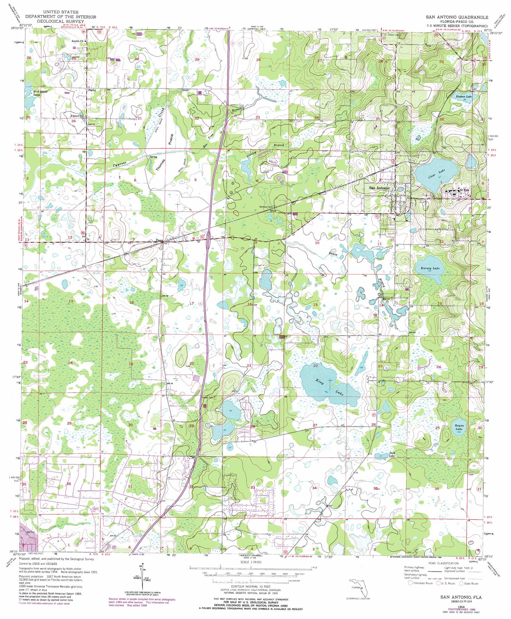
USGS Topo Quad 28082c3 - 1:24,000 scale
| Topo Map Name: | San Antonio |
| USGS Topo Quad ID: | 28082c3 |
| Print Size: | ca. 21 1/4" wide x 27" high |
| Southeast Coordinates: | 28.25° N latitude / 82.25° W longitude |
| Map Center Coordinates: | 28.3125° N latitude / 82.3125° W longitude |
| U.S. State: | FL |
| Filename: | O28082C3.jpg |
| Download Map JPG Image: | San Antonio topo map 1:24,000 scale |
| Map Type: | Topographic |
| Topo Series: | 7.5´ |
| Map Scale: | 1:24,000 |
| Source of Map Images: | United States Geological Survey (USGS) |
| Alternate Map Versions: |
San Antonio FL 1954, updated 1955 Download PDF Buy paper map San Antonio FL 1954, updated 1969 Download PDF Buy paper map San Antonio FL 1954, updated 1988 Download PDF Buy paper map San Antonio FL 2012 Download PDF Buy paper map San Antonio FL 2015 Download PDF Buy paper map |
1:24,000 Topo Quads surrounding San Antonio
Weeki Wachee Spring |
Brooksville |
Brooksville Se |
Saint Catherine |
Webster |
Port Richey Ne |
Masaryktown |
Spring Lake |
Lacoochee |
Clay Sink |
Fivay Junction |
Ehren |
San Antonio |
Dade City |
Branchborough |
Odessa |
Lutz |
Wesley Chapel |
Zephyrhills |
Socrum |
Citrus Park |
Sulphur Springs |
Thonotosassa |
Plant City West |
Plant City East |
> Back to 28082a1 at 1:100,000 scale
> Back to 28082a1 at 1:250,000 scale
> Back to U.S. Topo Maps home
San Antonio topo map: Gazetteer
San Antonio: Airports
Gator Lake Heliport elevation 35m 114′San Antonio: Flats
Thomas Prairie elevation 23m 75′San Antonio: Lakes
Bayou Lake elevation 33m 108′Bird Island Lakes elevation 23m 75′
Clear Lake elevation 39m 127′
Dick Lake elevation 33m 108′
Hudson Lake elevation 27m 88′
Karney Lake elevation 32m 104′
King Lake elevation 31m 101′
San Antonio: Populated Places
Darby elevation 35m 114′Pasco elevation 30m 98′
Saint Leo elevation 57m 187′
San Antonio elevation 51m 167′
San Antonio: Streams
Bayou Branch elevation 27m 88′Bee Tree Branch elevation 24m 78′
Stanley Branch elevation 26m 85′
San Antonio digital topo map on disk
Buy this San Antonio topo map showing relief, roads, GPS coordinates and other geographical features, as a high-resolution digital map file on DVD: