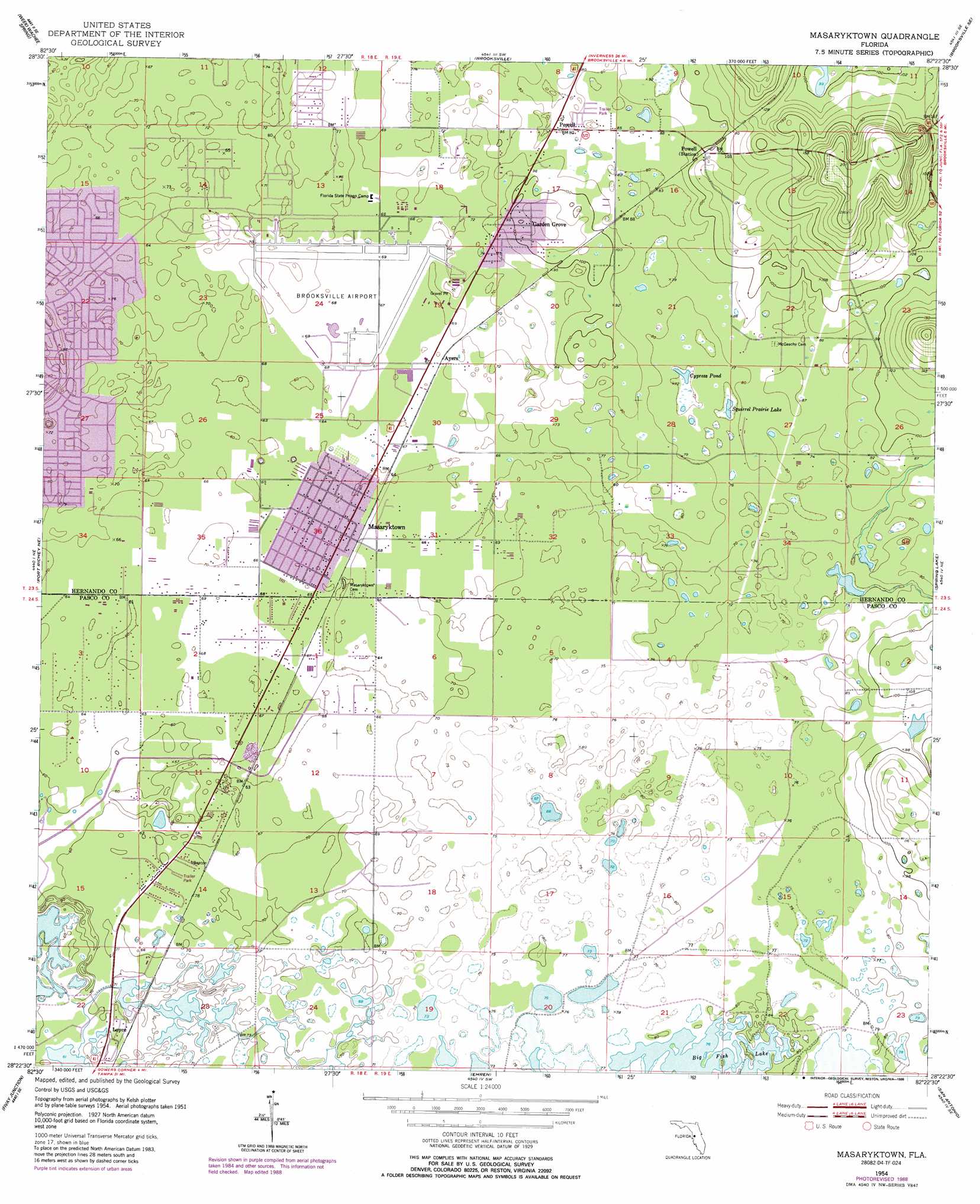
Masaryktown Topo Map Florida
To zoom in, hover over the map of Masaryktown
USGS Topo Quad 28082d4 - 1:24,000 scale
| Topo Map Name: | Masaryktown |
| USGS Topo Quad ID: | 28082d4 |
| Print Size: | ca. 21 1/4" wide x 27" high |
| Southeast Coordinates: | 28.375° N latitude / 82.375° W longitude |
| Map Center Coordinates: | 28.4375° N latitude / 82.4375° W longitude |
| U.S. State: | FL |
| Filename: | O28082D4.jpg |
| Download Map JPG Image: | Masaryktown topo map 1:24,000 scale |
| Map Type: | Topographic |
| Topo Series: | 7.5´ |
| Map Scale: | 1:24,000 |
| Source of Map Images: | United States Geological Survey (USGS) |
| Alternate Map Versions: |
Masaryktown FL 1954, updated 1955 Download PDF Buy paper map Masaryktown FL 1954, updated 1966 Download PDF Buy paper map Masaryktown FL 1954, updated 1988 Download PDF Buy paper map Masaryktown FL 2012 Download PDF Buy paper map Masaryktown FL 2015 Download PDF Buy paper map |
1:24,000 Topo Quads surrounding Masaryktown
Chassahowitzka Bay |
Chassahowitzka |
Brooksville Nw |
Nobelton |
Wahoo |
Bayport |
Weeki Wachee Spring |
Brooksville |
Brooksville Se |
Saint Catherine |
Aripeka |
Port Richey Ne |
Masaryktown |
Spring Lake |
Lacoochee |
Port Richey |
Fivay Junction |
Ehren |
San Antonio |
Dade City |
Elfers |
Odessa |
Lutz |
Wesley Chapel |
Zephyrhills |
> Back to 28082a1 at 1:100,000 scale
> Back to 28082a1 at 1:250,000 scale
> Back to U.S. Topo Maps home
Masaryktown topo map: Gazetteer
Masaryktown: Airports
Hernando County Airport elevation 20m 65′Masaryktown: Lakes
Big Fish Lake elevation 23m 75′Cypress Pond elevation 21m 68′
Squirrel Prairie Lake elevation 21m 68′
Masaryktown: Populated Places
Ayers elevation 20m 65′Garden Grove elevation 29m 95′
Loyce elevation 21m 68′
Masaryktown elevation 19m 62′
Powell elevation 23m 75′
South Masaryktown elevation 19m 62′
Masaryktown digital topo map on disk
Buy this Masaryktown topo map showing relief, roads, GPS coordinates and other geographical features, as a high-resolution digital map file on DVD: