Brooksville Se Topo Map Florida
To zoom in, hover over the map of Brooksville Se
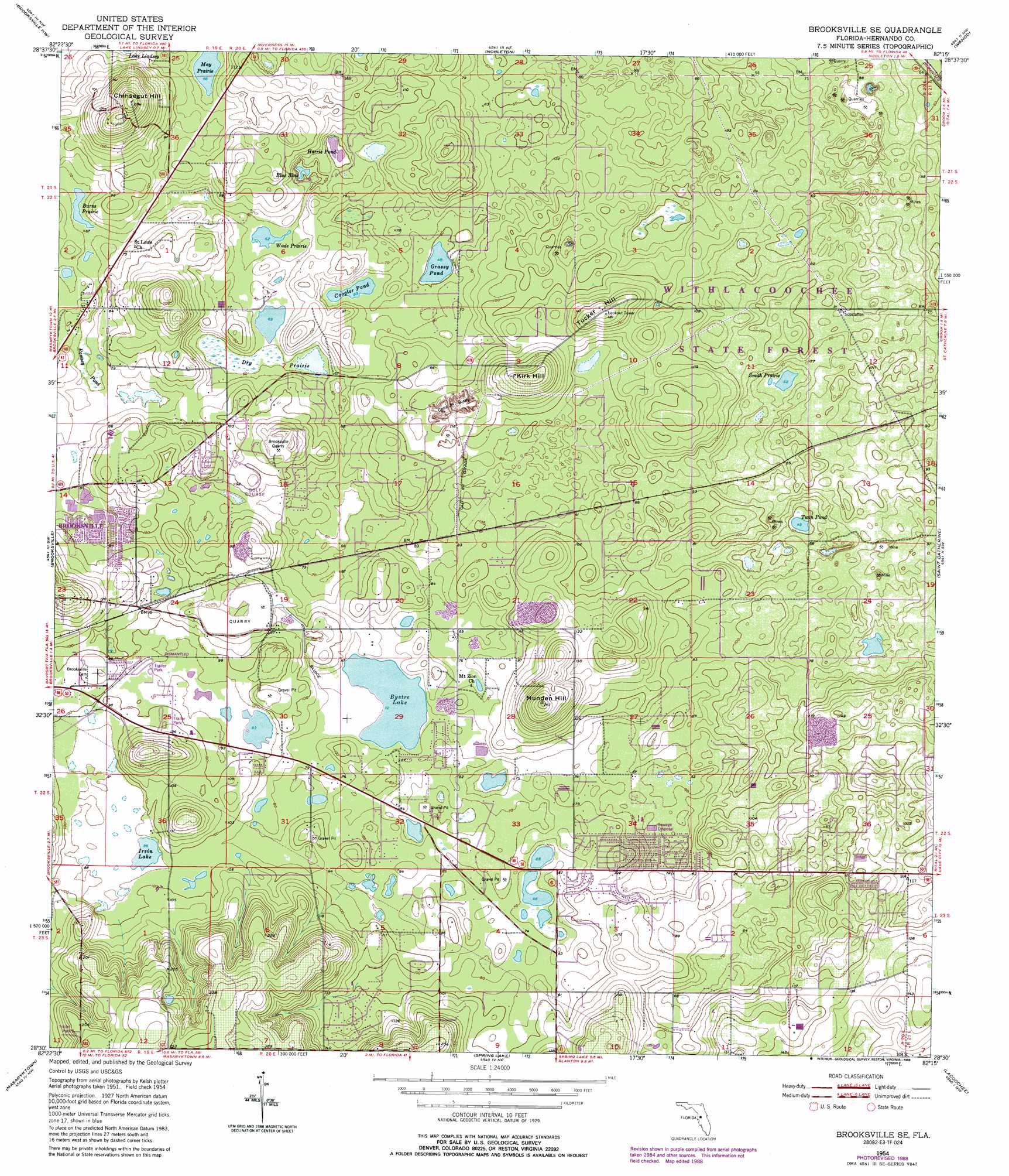
USGS Topo Quad 28082e3 - 1:24,000 scale
| Topo Map Name: | Brooksville Se |
| USGS Topo Quad ID: | 28082e3 |
| Print Size: | ca. 21 1/4" wide x 27" high |
| Southeast Coordinates: | 28.5° N latitude / 82.25° W longitude |
| Map Center Coordinates: | 28.5625° N latitude / 82.3125° W longitude |
| U.S. State: | FL |
| Filename: | O28082E3.jpg |
| Download Map JPG Image: | Brooksville Se topo map 1:24,000 scale |
| Map Type: | Topographic |
| Topo Series: | 7.5´ |
| Map Scale: | 1:24,000 |
| Source of Map Images: | United States Geological Survey (USGS) |
| Alternate Map Versions: |
Brooksville SE FL 1954, updated 1955 Download PDF Buy paper map Brooksville SE FL 1954, updated 1968 Download PDF Buy paper map Brooksville SE FL 1954, updated 1988 Download PDF Buy paper map Brooksville SE FL 2012 Download PDF Buy paper map Brooksville SE FL 2015 Download PDF Buy paper map |
1:24,000 Topo Quads surrounding Brooksville Se
Homosassa |
Lecanto |
Inverness |
Rutland |
Wildwood |
Chassahowitzka |
Brooksville Nw |
Nobelton |
Wahoo |
Bushnell |
Weeki Wachee Spring |
Brooksville |
Brooksville Se |
Saint Catherine |
Webster |
Port Richey Ne |
Masaryktown |
Spring Lake |
Lacoochee |
Clay Sink |
Fivay Junction |
Ehren |
San Antonio |
Dade City |
Branchborough |
> Back to 28082e1 at 1:100,000 scale
> Back to 28082a1 at 1:250,000 scale
> Back to U.S. Topo Maps home
Brooksville Se topo map: Gazetteer
Brooksville Se: Airports
Chinsegut Airport elevation 37m 121′Brooksville Se: Flats
Dry Prairie elevation 17m 55′Smith Prairie elevation 16m 52′
Brooksville Se: Lakes
Blue Sink elevation 14m 45′Burns Prairie elevation 20m 65′
Bystre Lake elevation 22m 72′
Coogler Pond elevation 16m 52′
Grassy Pond elevation 14m 45′
Harris Pond elevation 13m 42′
Irvin Lake elevation 26m 85′
May Prairie elevation 20m 65′
Twin Pond elevation 15m 49′
Wade Prairie elevation 16m 52′
Brooksville Se: Mines
Brooksville Quarry elevation 44m 144′Camp Quarry elevation 21m 68′
Brooksville Se: Parks
Chinsegut National Wildlife Refuge (historical) elevation 53m 173′Croom Wildlife Management Area elevation 27m 88′
Brooksville Se: Populated Places
Conrock elevation 32m 104′Hill 'n Dale elevation 33m 108′
Brooksville Se: Summits
Chinsegut Hill elevation 82m 269′Kirk Hill elevation 65m 213′
Munden Hill elevation 80m 262′
Tucker Hill elevation 55m 180′
Brooksville Se: Swamps
Ramsey Pond elevation 21m 68′Brooksville Se digital topo map on disk
Buy this Brooksville Se topo map showing relief, roads, GPS coordinates and other geographical features, as a high-resolution digital map file on DVD: