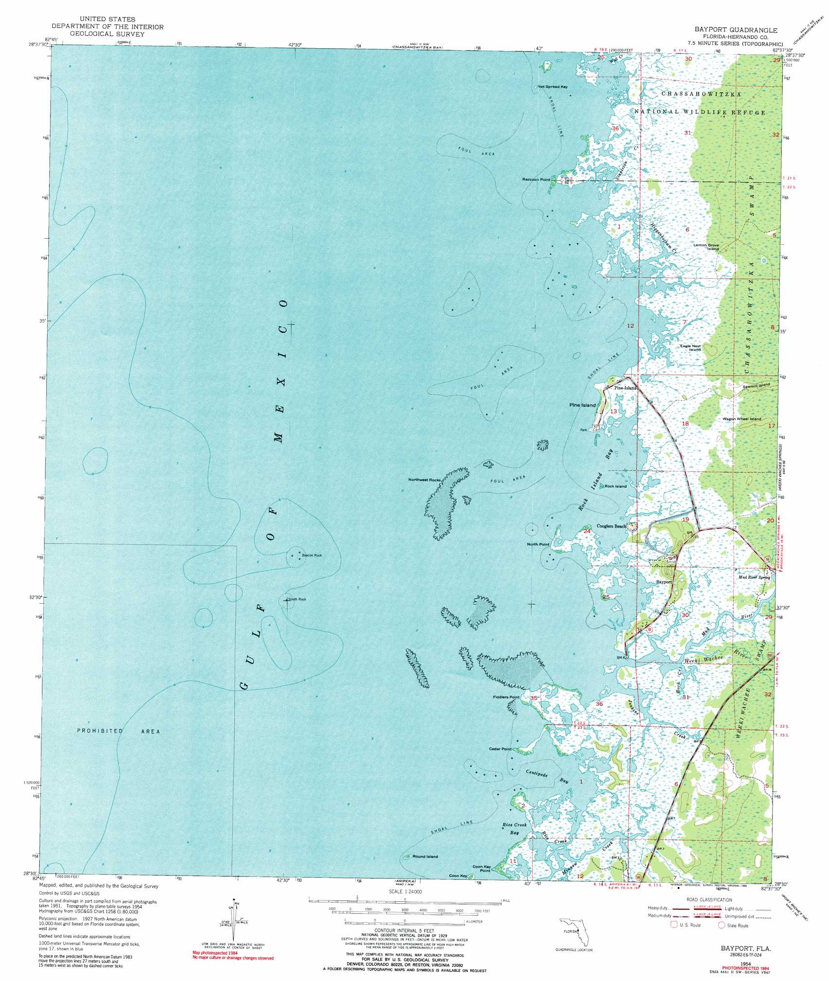
Bayport Topo Map Florida
To zoom in, hover over the map of Bayport
USGS Topo Quad 28082e6 - 1:24,000 scale
| Topo Map Name: | Bayport |
| USGS Topo Quad ID: | 28082e6 |
| Print Size: | ca. 21 1/4" wide x 27" high |
| Southeast Coordinates: | 28.5° N latitude / 82.625° W longitude |
| Map Center Coordinates: | 28.5625° N latitude / 82.6875° W longitude |
| U.S. State: | FL |
| Filename: | O28082E6.jpg |
| Download Map JPG Image: | Bayport topo map 1:24,000 scale |
| Map Type: | Topographic |
| Topo Series: | 7.5´ |
| Map Scale: | 1:24,000 |
| Source of Map Images: | United States Geological Survey (USGS) |
| Alternate Map Versions: |
Bayport FL 1954, updated 1955 Download PDF Buy paper map Bayport FL 1954, updated 1965 Download PDF Buy paper map Bayport FL 1954, updated 1973 Download PDF Buy paper map Bayport FL 1954, updated 1990 Download PDF Buy paper map Bayport FL 1954, updated 1990 Download PDF Buy paper map Bayport FL 2012 Download PDF Buy paper map Bayport FL 2015 Download PDF Buy paper map |
1:24,000 Topo Quads surrounding Bayport
Ozello |
Homosassa |
Lecanto |
||
Chassahowitzka Bay |
Chassahowitzka |
Brooksville Nw |
||
Bayport |
Weeki Wachee Spring |
Brooksville |
||
Aripeka |
Port Richey Ne |
Masaryktown |
||
Port Richey |
Fivay Junction |
Ehren |
> Back to 28082e1 at 1:100,000 scale
> Back to 28082a1 at 1:250,000 scale
> Back to U.S. Topo Maps home
Bayport topo map: Gazetteer
Bayport: Bays
Centipede Bay elevation 0m 0′Rice Creek Bay elevation 0m 0′
Rock Island Bay elevation 0m 0′
Bayport: Capes
Cedar Point elevation 0m 0′Coon Key Point elevation 0m 0′
Fiddlers Point elevation 0m 0′
North Point elevation 0m 0′
Raccoon Point elevation 0m 0′
Bayport: Guts
Higgenbotham Creek elevation 0m 0′Bayport: Islands
Beacon Rock elevation 0m 0′Coon Key elevation 0m 0′
Eagle Nest Island elevation 1m 3′
Lemon Grove Island elevation 1m 3′
Net Spread Key elevation 0m 0′
Northwest Rocks elevation 0m 0′
Pine Island elevation 1m 3′
Rock Island elevation 0m 0′
Round Island elevation 0m 0′
Sawmill Island elevation 3m 9′
South Rock elevation 0m 0′
Wagon Wheel Island elevation 1m 3′
Bayport: Populated Places
Bayport elevation 1m 3′Cooglers Beach elevation 1m 3′
Palm Grove Colony elevation 1m 3′
Pine Island elevation 1m 3′
Weeki Wachee Gardens elevation 1m 3′
Bayport: Springs
Mud River Spring elevation 1m 3′Bayport: Streams
Jenkins Creek elevation 0m 0′Mud River elevation 0m 0′
Rice Creek elevation 0m 0′
Rock Creek elevation 1m 3′
Stapleton Creek elevation 0m 0′
Wall Creek elevation 0m 0′
Weeki Wachee River elevation 0m 0′
Bayport digital topo map on disk
Buy this Bayport topo map showing relief, roads, GPS coordinates and other geographical features, as a high-resolution digital map file on DVD: