Rutland Topo Map Florida
To zoom in, hover over the map of Rutland
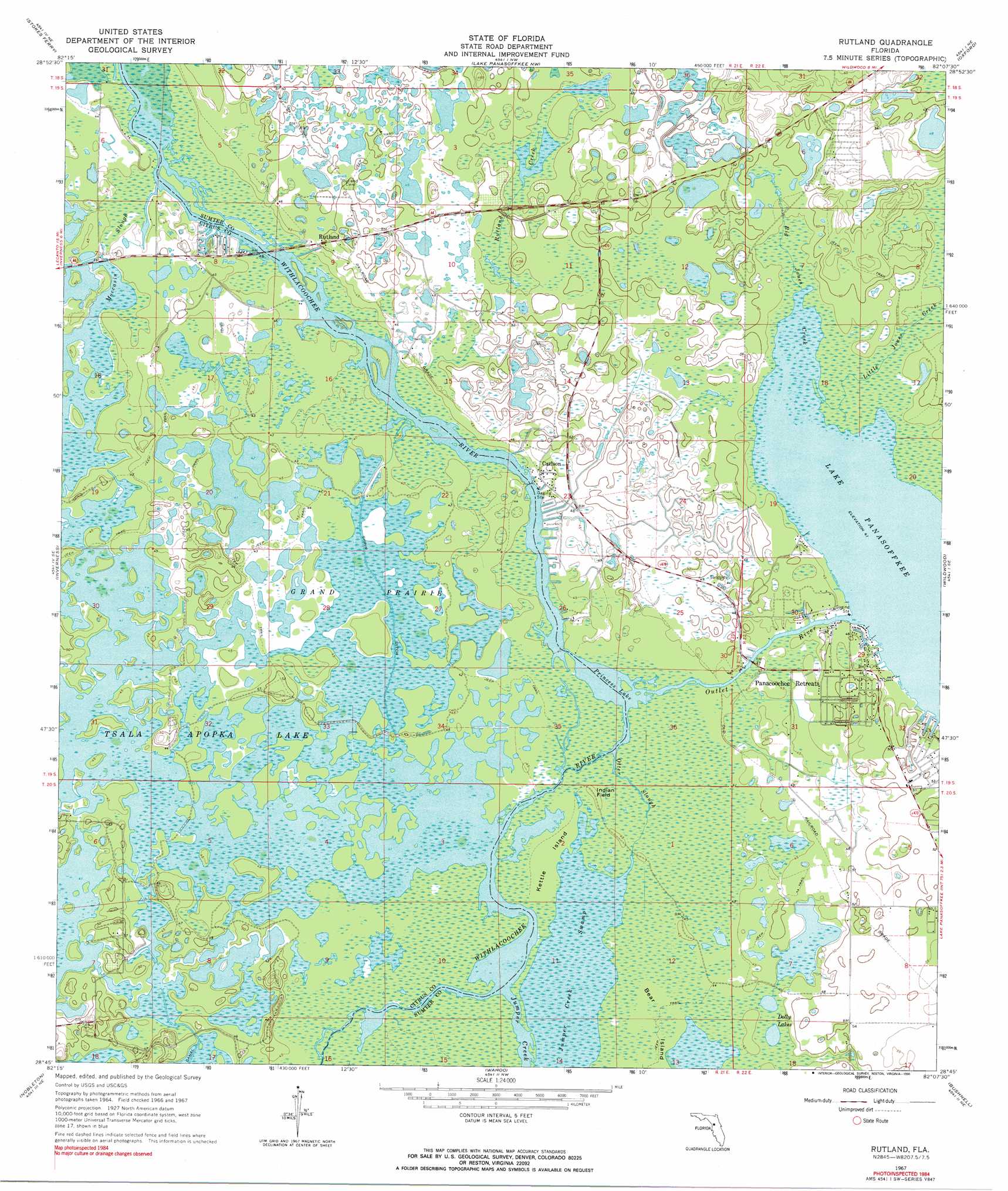
USGS Topo Quad 28082g2 - 1:24,000 scale
| Topo Map Name: | Rutland |
| USGS Topo Quad ID: | 28082g2 |
| Print Size: | ca. 21 1/4" wide x 27" high |
| Southeast Coordinates: | 28.75° N latitude / 82.125° W longitude |
| Map Center Coordinates: | 28.8125° N latitude / 82.1875° W longitude |
| U.S. State: | FL |
| Filename: | O28082G2.jpg |
| Download Map JPG Image: | Rutland topo map 1:24,000 scale |
| Map Type: | Topographic |
| Topo Series: | 7.5´ |
| Map Scale: | 1:24,000 |
| Source of Map Images: | United States Geological Survey (USGS) |
| Alternate Map Versions: |
Rutland FL 1967, updated 1968 Download PDF Buy paper map Rutland FL 1967, updated 1990 Download PDF Buy paper map Rutland FL 2012 Download PDF Buy paper map Rutland FL 2015 Download PDF Buy paper map |
1:24,000 Topo Quads surrounding Rutland
Dunnellon |
Dunnellon Se |
Shady |
Belleview |
Lake Weir |
Holder |
Stokes Ferry |
Lake Panasoffkee Nw |
Oxford |
Lady Lake |
Lecanto |
Inverness |
Rutland |
Wildwood |
Leesburg West |
Brooksville Nw |
Nobelton |
Wahoo |
Bushnell |
Center Hill |
Brooksville |
Brooksville Se |
Saint Catherine |
Webster |
Mascotte |
> Back to 28082e1 at 1:100,000 scale
> Back to 28082a1 at 1:250,000 scale
> Back to U.S. Topo Maps home
Rutland topo map: Gazetteer
Rutland: Airports
Montgomerys Flying M Ranch Airport elevation 15m 49′Rutland: Channels
Outlet River elevation 12m 39′Rutland: Flats
Grand Prairie elevation 12m 39′Rutland: Guts
Otter Slough elevation 13m 42′Rutland: Islands
Indian Field elevation 13m 42′Kettle Island elevation 13m 42′
Rutland: Lakes
Dolly Lakes elevation 13m 42′Princess Lake elevation 12m 39′
Rutland: Populated Places
Carlson elevation 13m 42′Panacoochee Park Mobile Home Park elevation 13m 42′
Panacoochee Retreats elevation 14m 45′
River Estates Mobile Home Park elevation 13m 42′
Rutland elevation 15m 49′
Seminole Haven Mobile Home Park elevation 13m 42′
Rutland: Post Offices
Lake Panasoffkee Post Office elevation 15m 49′Lake Panasoffkee Post Office elevation 15m 49′
Rutland: Streams
Big Jones Creek elevation 12m 39′Jumper Creek elevation 12m 39′
Little Jones Creek elevation 13m 42′
Rutland Creek elevation 13m 42′
Rutland: Swamps
Moccasin Slough elevation 12m 39′Rutland digital topo map on disk
Buy this Rutland topo map showing relief, roads, GPS coordinates and other geographical features, as a high-resolution digital map file on DVD: