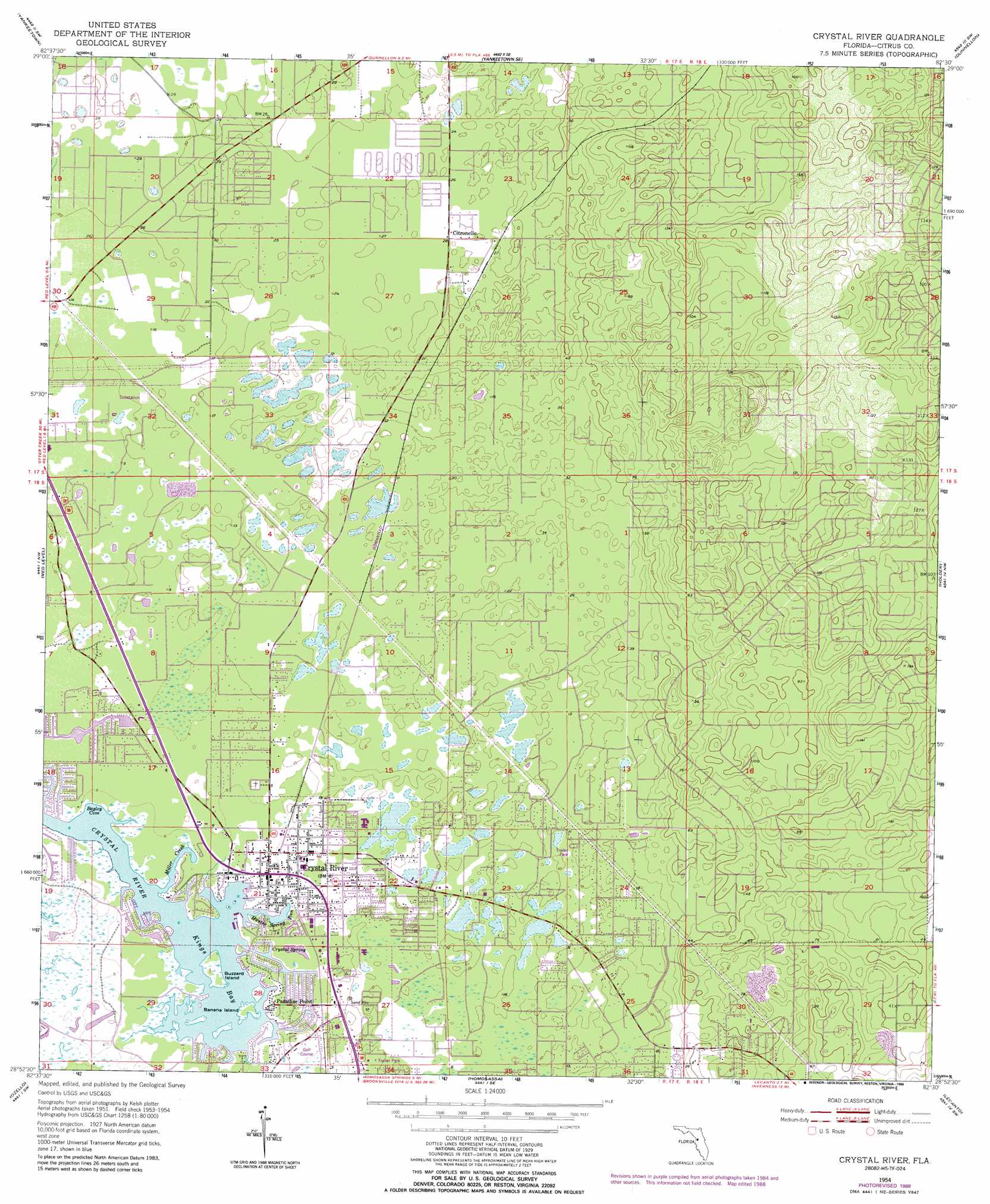
Crystal River Topo Map Florida
To zoom in, hover over the map of Crystal River
USGS Topo Quad 28082h5 - 1:24,000 scale
| Topo Map Name: | Crystal River |
| USGS Topo Quad ID: | 28082h5 |
| Print Size: | ca. 21 1/4" wide x 27" high |
| Southeast Coordinates: | 28.875° N latitude / 82.5° W longitude |
| Map Center Coordinates: | 28.9375° N latitude / 82.5625° W longitude |
| U.S. State: | FL |
| Filename: | O28082H5.jpg |
| Download Map JPG Image: | Crystal River topo map 1:24,000 scale |
| Map Type: | Topographic |
| Topo Series: | 7.5´ |
| Map Scale: | 1:24,000 |
| Source of Map Images: | United States Geological Survey (USGS) |
| Alternate Map Versions: |
Crystal River FL 1954, updated 1955 Download PDF Buy paper map Crystal River FL 1954, updated 1965 Download PDF Buy paper map Crystal River FL 1954, updated 1988 Download PDF Buy paper map Crystal River FL 2012 Download PDF Buy paper map Crystal River FL 2015 Download PDF Buy paper map |
1:24,000 Topo Quads surrounding Crystal River
Waccasassa Bay |
Lebanon Station |
Tidewater |
Romeo |
Cotton Plant |
Withlacoochee Bay |
Yankeetown |
Yankeetown Se |
Dunnellon |
Dunnellon Se |
Red Level |
Crystal River |
Holder |
Stokes Ferry |
|
Ozello |
Homosassa |
Lecanto |
Inverness |
|
Chassahowitzka Bay |
Chassahowitzka |
Brooksville Nw |
Nobelton |
> Back to 28082e1 at 1:100,000 scale
> Back to 28082a1 at 1:250,000 scale
> Back to U.S. Topo Maps home
Crystal River topo map: Gazetteer
Crystal River: Bays
Bagley Cove elevation 0m 0′Crystal River: Guts
Hunter Spring Run elevation 0m 0′Miller Creek elevation 0m 0′
Crystal River: Islands
Banana Island elevation 0m 0′Buzzard Island elevation 0m 0′
Crystal River: Lakes
Kings Bay elevation 0m 0′Crystal River: Parks
Citronelle Park elevation 6m 19′Little Springs Park elevation 1m 3′
Crystal River: Populated Places
Citronelle elevation 8m 26′Crystal River elevation 2m 6′
Paradise Point elevation 0m 0′
Crystal River: Springs
Crystal Spring elevation 1m 3′Crystal River: Streams
Magnolia Creek elevation 0m 0′Crystal River digital topo map on disk
Buy this Crystal River topo map showing relief, roads, GPS coordinates and other geographical features, as a high-resolution digital map file on DVD: