Austwell Topo Map Texas
To zoom in, hover over the map of Austwell
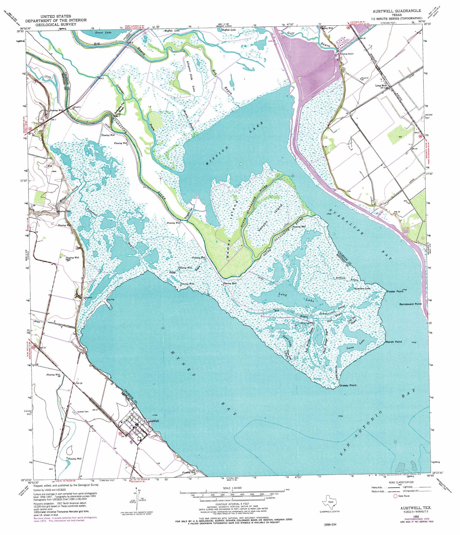
USGS Topo Quad 28096d7 - 1:24,000 scale
| Topo Map Name: | Austwell |
| USGS Topo Quad ID: | 28096d7 |
| Print Size: | ca. 21 1/4" wide x 27" high |
| Southeast Coordinates: | 28.375° N latitude / 96.75° W longitude |
| Map Center Coordinates: | 28.4375° N latitude / 96.8125° W longitude |
| U.S. State: | TX |
| Filename: | o28096d7.jpg |
| Download Map JPG Image: | Austwell topo map 1:24,000 scale |
| Map Type: | Topographic |
| Topo Series: | 7.5´ |
| Map Scale: | 1:24,000 |
| Source of Map Images: | United States Geological Survey (USGS) |
| Alternate Map Versions: |
Austwell TX 1952, updated 1953 Download PDF Buy paper map Austwell TX 1952, updated 1963 Download PDF Buy paper map Austwell TX 1952, updated 1976 Download PDF Buy paper map Austwell TX 2010 Download PDF Buy paper map Austwell TX 2013 Download PDF Buy paper map Austwell TX 2016 Download PDF Buy paper map |
1:24,000 Topo Quads surrounding Austwell
Raisin |
Bloomington |
Placedo |
Kamey |
Point Comfort |
Mcfaddin |
Bloomington Sw |
Green Lake |
Port Lavaca West |
Port Lavaca East |
Lake Pasture |
Tivoli |
Austwell |
Seadrift |
Seadrift Ne |
Twin Mott Lake |
Tivoli Sw |
Tivoli Se |
Mosquito Point |
Long Island |
Lamar |
Saint Charles Bay |
Mesquite Bay |
Panther Point |
Panther Point Ne |
> Back to 28096a1 at 1:100,000 scale
> Back to 28096a1 at 1:250,000 scale
> Back to U.S. Topo Maps home
Austwell topo map: Gazetteer
Austwell: Airports
Gulf Coast Airport elevation 11m 36′Whatley Flying Service Airport elevation 6m 19′
Austwell: Bays
Guadalupe Bay elevation 0m 0′Hynes Bay elevation 0m 0′
Mission Lake elevation 0m 0′
Austwell: Capes
Bendewald Point elevation 0m 0′Foster Point elevation 0m 0′
Grassy Point elevation 0m 0′
Marsh Point elevation 0m 0′
Austwell: Channels
Taylor Cut elevation 1m 3′Austwell: Dams
Operating Basin Number 1 Levee elevation 8m 26′Austwell: Guts
Big Bayou elevation 1m 3′Cast Net Bayou elevation 1m 3′
Flat Bayou elevation 0m 0′
Plank Bridge Bayou elevation 0m 0′
Pole Bridge Bayou elevation 0m 0′
Sommerville Bayou elevation 1m 3′
Swan Lake Bayou elevation 0m 0′
Varnum Bayou elevation 1m 3′
Austwell: Harbors
Storm Harbor elevation 1m 3′Austwell: Islands
Kamey Island elevation 2m 6′Kenyon Island elevation 1m 3′
Austwell: Lakes
Alligator Slide Lake elevation 1m 3′Hamilton Lake elevation 1m 3′
Long Lake elevation 1m 3′
Lucas Lake elevation 0m 0′
Swan Lake elevation 1m 3′
Austwell: Parks
Guadalupe Delta Wildlife Management Area elevation 0m 0′Austwell: Populated Places
Austwell elevation 7m 22′Long Mott elevation 6m 19′
Austwell: Reservoirs
Operating Basin Number 1 elevation 8m 26′Austwell: Streams
Boggy Bayou elevation 0m 0′Guadalupe River elevation 2m 6′
Hog Bayou elevation 0m 0′
Mamie Bayou elevation 0m 0′
Miller Creek elevation 1m 3′
North Guadalupe River elevation 0m 0′
Redfish Bayou elevation 0m 0′
Schwings Bayou elevation 0m 0′
South Guadalupe River elevation 1m 3′
Swimming Pen Slough elevation 1m 3′
Townsend Bayou elevation 1m 3′
Austwell digital topo map on disk
Buy this Austwell topo map showing relief, roads, GPS coordinates and other geographical features, as a high-resolution digital map file on DVD: