Hensley Lake Topo Map Texas
To zoom in, hover over the map of Hensley Lake
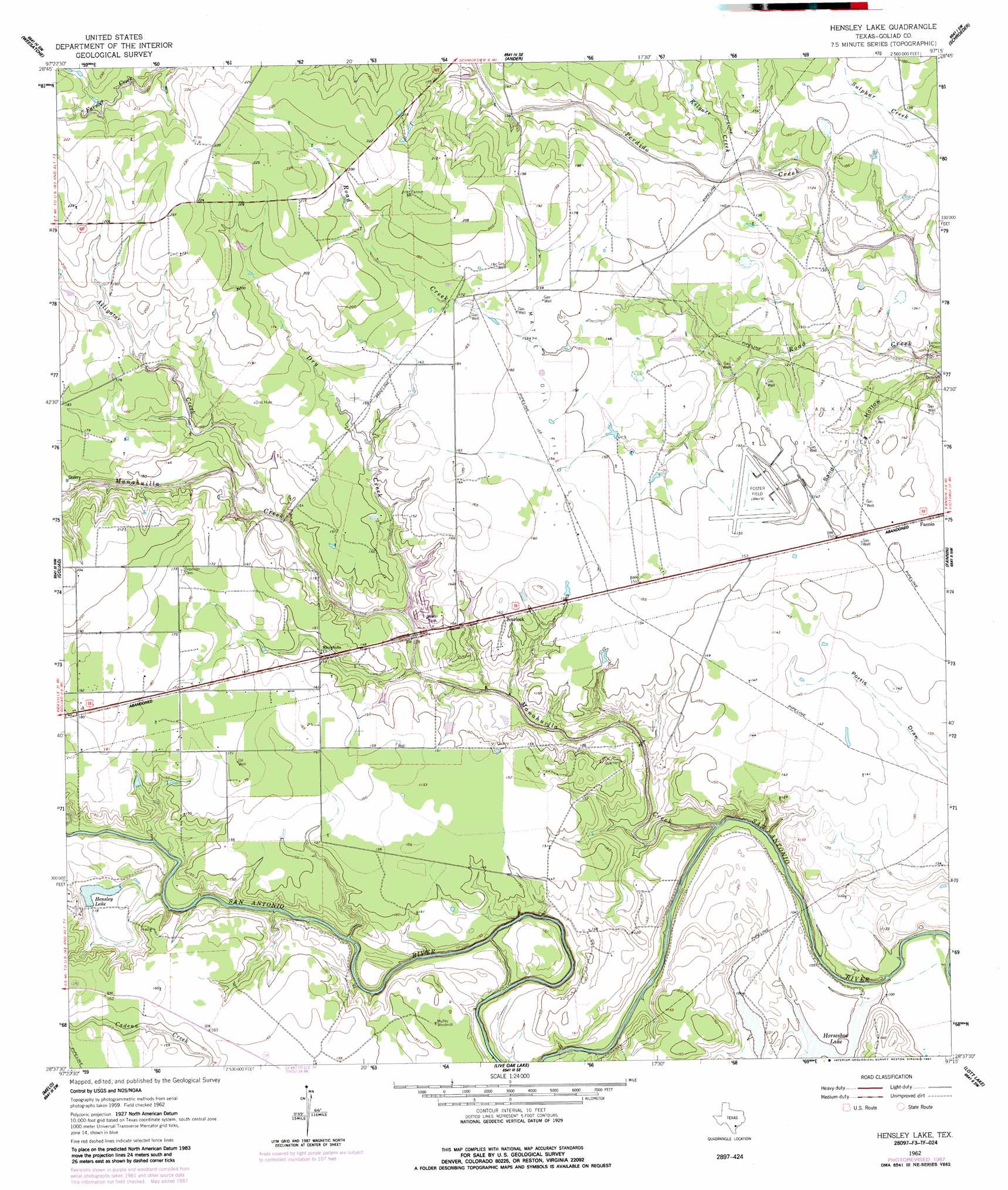
USGS Topo Quad 28097f3 - 1:24,000 scale
| Topo Map Name: | Hensley Lake |
| USGS Topo Quad ID: | 28097f3 |
| Print Size: | ca. 21 1/4" wide x 27" high |
| Southeast Coordinates: | 28.625° N latitude / 97.25° W longitude |
| Map Center Coordinates: | 28.6875° N latitude / 97.3125° W longitude |
| U.S. State: | TX |
| Filename: | o28097f3.jpg |
| Download Map JPG Image: | Hensley Lake topo map 1:24,000 scale |
| Map Type: | Topographic |
| Topo Series: | 7.5´ |
| Map Scale: | 1:24,000 |
| Source of Map Images: | United States Geological Survey (USGS) |
| Alternate Map Versions: |
Hensley Lake TX 1962, updated 1964 Download PDF Buy paper map Hensley Lake TX 1962, updated 1987 Download PDF Buy paper map Hensley Lake TX 2010 Download PDF Buy paper map Hensley Lake TX 2013 Download PDF Buy paper map Hensley Lake TX 2016 Download PDF Buy paper map |
1:24,000 Topo Quads surrounding Hensley Lake
Yorktown West |
Yorktown East |
Meyersville |
Mission Valley |
Nursery |
Runge Se |
Weesatche |
Ander |
Schroeder |
Victoria West |
Charco |
Goliad |
Hensley Lake |
Fannin |
Raisin |
Berclair |
Melo |
Live Oak Lake |
Lott Lake |
Mcfaddin |
Skidmore Ne |
Blanconia |
Ryanville |
Vidaurri |
Lake Pasture |
> Back to 28097e1 at 1:100,000 scale
> Back to 28096a1 at 1:250,000 scale
> Back to U.S. Topo Maps home
Hensley Lake topo map: Gazetteer
Hensley Lake: Dams
Hensley Lake Dam elevation 36m 118′Hensley Lake: Lakes
Horseshoe Lake elevation 30m 98′Hensley Lake: Oilfields
Alkek Oil Field elevation 44m 144′Matze Oil Field elevation 46m 150′
Hensley Lake: Populated Places
Scurlock elevation 49m 160′Hensley Lake: Reservoirs
Hensley Lake elevation 37m 121′Hensley Lake: Streams
Alligator Creek elevation 33m 108′Dry Creek elevation 33m 108′
Kilgore Creek elevation 34m 111′
Manahuilla Creek elevation 21m 68′
Hensley Lake digital topo map on disk
Buy this Hensley Lake topo map showing relief, roads, GPS coordinates and other geographical features, as a high-resolution digital map file on DVD: